Tag Archives: North-east treks

Hiking up Assam’s highest point- Hapeo peak

This post is part of my fortnight long road trip across North-east India, specifically covering parts of Meghalaya – Assam – Arunachal Pradesh I had tagged along with two other travelers and drove around the places in a self-drive car hired at Guwahati. We had arrived at Haflong, the only hill station in the state of Assam following a mis-adventurous trip. (Click here to know the details)

This trek to the highest point in Assam happened by chance, as a backup after the original plan for the day had failed. We were told that the hill isn’t yet popular in a typical tourist’s circuit. Apart from the local tribal folk who like to party atop the hill, hardly 4 to 5 trekkers come here from outside the district and the state to climb this hill each year. Having said that, we wanted to reach Hapeo peak, the highest point in the state of Assam for sunrise. However, due to the clouds that had hovered that morning, we decided to snooze for a little longer before going ahead with the plan.

There are totally 13 native tribes in Dima Hasao district of Assam state and each tribe has its own village. A local NGO called spectrum is working towards the empowerment of the local tribal communities through promotion of tourism in the district. They helped us in getting this event organized. We were driven in their 4WD vehicle from Haflong to a village called N.Liekung. N.Liekung village belonged to the Kuki tribes and the required permits from the village head was arranged by Spectrum. A local guide was assigned to take us through this off-beat wilderness to scale the highest point in Assam. I would like to present my trek in essentially three parts.

Part 1: The Ascent

After a small stop in front of the holy Cross at the prayer area of the Kukis, we began our ascent towards the peak. For the three of us, all seasoned trekkers doing this trip together, the climb to Hapeo peak wasn’t a very difficult one as compared to what we had done back in the Southern India. But what made it seem difficult was the high grass that had grown tall enough to cover the entire stretch. Since the trek is not frequented with people, the grass on the path is not worn out as much as in the popular trekking trails. Hence, the way up was something through which we had to FIND the trekking trail. Based on the ease of finding the trail, I would split the trail into three portions:

  • A well traceable path with steps laid. However, at some places, the stairs have been lost amid the thickets. We had to cut the grass and bushes in order to find our way. The stretch was full of high grass with occasionally placed animal traps which our guide who walked ahead, would carefully move aside and make way for us.
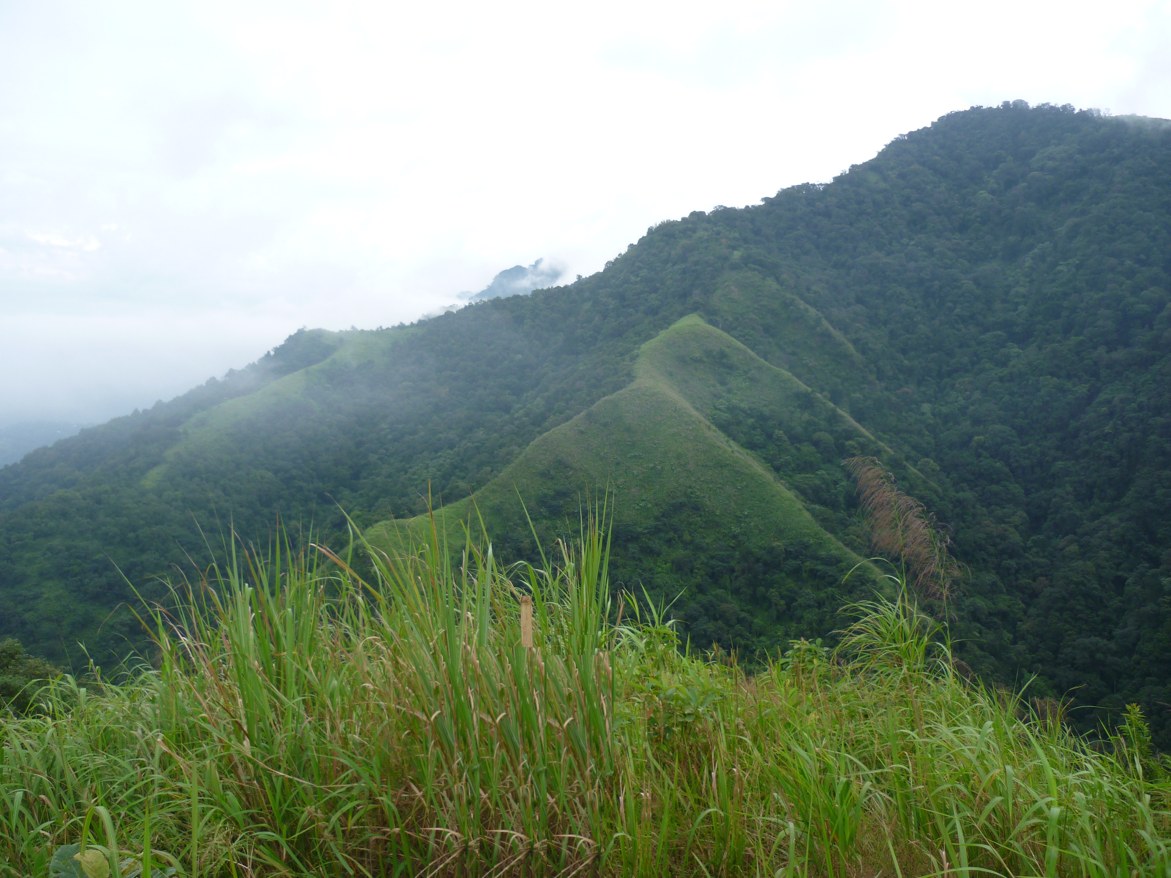
  • This was the only flat area with some grassland vegetation for a stretch of around 500mts.This was the only place apart from the highway, from where we could actually see the peak that we were apparently scaling up!
  • The last part passes through thick jungle, with a canopy of trees that allowed very less sunlight to penetrate. Varieties of innocent looking wild mushrooms had bloomed at several patches, but we were warned not to pick any of them as they could actually be lethal with allergens or venom. We were accompanied by strange sounds and cries of migratory birds around.
p1140545
The only grassland in Hapeo trek

As we climbed up while chatting up with our Kuki guide, he enlightened us with their tribal customs, culture and showed us a few videos on his phone of their traditional dances, festivals ceremonies and the like. Our guide jokingly told us how his fellow folks are named in the tribe. The names may not mean anything and just anything random that sounds nice goes as a name. He was thus randomly called after a ‘Song that was Sung’ (I’m sorry, I don’t want to give out his name). But the tradition is, that the maternal grandfather selects a name for the granddaughter and the paternal grandmother picks a name for the grandson and vice-versa. It is a patrilineal system of inheritance.

Part 2: Reaching the Top

Suddenly, the darkness of the jungle had turned into snow white of the clouds. Before we could realise, we had reached the top already and we had barely taken us two hours. We were told that one could see the entire district of Dima Hasao from up there. But, we were greeted with thick fog and clouds upon arrival. We spent some time soaking in nature’s beauty and waited for the clouds to clear so that we could catch a glimpse of the beautiful view.

For the benefit of potential trekkers, there is just one small shelter with a bench atop the hill and nothing apart from yourself there! Our guide mentioned to us about a patch of land measuring about 2×2 feet, right behind the bench where a natural and strong magnetic force is believed to exist, due to which none of the mobile phones work in that spot. Yes, we tested the phenomenon too. Although all our phones had FULL network, we were unable to place any calls. But none of us had any scientific reasoning for what he told.

p1140551
A view of Dima Hasao district from Hapeo peak

In the next fifteen minutes, the clouds had slowly started to clear. We spotted the railway bridge at Lumding onto the right side of the horizon. This rail line is the longest and highest in the Silchar route. Our guide pointed towards another hill onto our left, through which the longest railway tunnel (around 3.5kms long) in the North-east passes. The Silchar-Lumding railway route has been featured in several tourism websites and has been one of the scenic stretches in the country. As the weather slowly worsened and began to drizzle, we decided to start our descent.

Part 3: The Descent

When we had just started to climb down and we received a call from the NGO. We were told to return to the base of the hill ASAP as an alert for a cyclone had been issued by the meterological department and heavy rains were expected in this region in the next few hours. But, it had started to pour cats and dogs within no time. The fastest pace we could catch was by rolling down the hill. With all the rain, thick grass covered path and steep gradient, just a steady walk itself was a struggle as we descended on the slippery trail. There was nothing enroute to take shelter from the rain. But, waiting at any place made no sense because the pounding rains would continue for the entire day or even two. It made more sense to simply continue to walk down as we were already drenched till our bones.

We were back at the base by 11.00.a.m. and thus ended our trek to the highest point in the state of Assam. We were invited over to our guide’s house to dry ourselves up and have a cup of hot tea. We thanked him much and bid adieu with a warm heart to this lesser known corner of the world!

A walk in God’s own garden- Mawlynnong

“The Soul of India is in its villages”.

-Gandhiji

Sometimes, it is not about the place.. It is about the people that brings you closer.. And that’s precisely my take on this little quaint village called Mawlynnong.. After a refreshing drive through some breathtaking views and best roads of India, we had alighted at ‘God’s Own garden’ nestled deep in the East Khasi hills of Meghalaya. Although it is being largely promoted by the Meghalaya Tourism Department(MTD) as Asia’s cleanest village after being awarded so by the ‘Discover India Magazine’ in 2003, I feel it holds a different charm in it with the warmest people I have met so far!

This post is part of my fortnight long road trip across North-east India, specifically covering parts of Meghalaya – Assam – Arunachal Pradesh I had tagged along with two other travelers and drove around the state of Meghalaya visiting Shillong – Smit – Cherrapunjee – Mawlynnong – Dawki – Ribhoi- Shillong.

Tourists flock to this place in large numbers just because they have heard about it in MTD handouts. These senseless creatures litter the place extensively with chocolate wrappers, chips sachets etc. all strewn around this supposedly cleanest village they have come to see.. But, the humble villagers watch on with a smile and pick up these wastes themselves and put them in the cane trash bins places visibly infront of every household in the village, thus keeping up to its reputation of being clean!

Things to see in Mawlynnong:

• Inside Mawlynnong village: The old church, floating stone, the water shed and the Bangladesh view point.
• 1 kilometer away: Riwai village (Living root-bridge)

The Details:

I walked around the laid back lanes of the village exploring the old church, the floating stone and the water shed maintained by the villagers. The flowers lining the fences of each household added myriad hues to the green village and grey of the cloudy sky.. I climbed up the skywalk laid up with bamboo and cane that threw up a nice view overlooking the plains of Bangladesh.

The Bangladesh view point at Mawlynnong
The Skyview bridge at Mawlynnong

Finally, I settled down at a locally run restaurant for a cup of chai to beat the chills of the cloudy weather. I caught up on a conversation with a pretty Khasi lady draped in her Asiangyake (the traditional dress of the Khasi women also called Dhara). While she helped me to memorise a few words in her dialect, I learnt about the Khasi culture and customs. Being a matrilineal society, women are respected and are given the preference to choose her husband-to-be. It is considered a bad omen, if a man proposes to a woman.

While she was attending to other customers at the restaurant, I called out for ‘Oikong’ (Khasi alternative for addressing ‘Didi’ in other parts of northern India) to help me with some Soh (Khasi for fruit). “Ohhhh” A voice filled with humility came in response… She then sat down with me and prepared a plate of pineapple seasoned with salt and flakes of the ‘Bhut Jholokias’ (the spiciest chilli in the world). It was one of the best snack I had in years!

I then walked down to the playground where some local kids were playing. They seemed excited to meet me, talk in English and pose for a few candid photos. It was a warm and a very pleasant evening for me. There is nothing in particular in this village to see or do.. Yet, the nomad in me strongly intended to stay there for an extra day. There are homestays that are available where the warmth of the Khasi hospitality can be experienced.

Kids playing on the lanes of Mawlynnong

I would recommend an early morning walk to Riwai village that helps you avoid the chaotic tourists who flock in later during the day. At a distance of about 1km before Mawlynnong, is the most easily accessible living root bridge and hence, a lot of visitors throng down. So after a nice walk, savouring a nice Khasi breakfast and lemon tea, it was time to pack bags to head out to my next destination- Dawki: the last village of Meghalaya on the Indian border!

The church at Mawlynnong

Request to tourists:

Please remember that the sole reason that you are at Mawlynnong is to see how ‘Asia’s cleanest village’ looks like. How on earth will you ever feel like littering such a place? Do you want to see if you can take off the ‘Cleanest’ tag from the place? Or do you want to just prove that you are only an uncultured educated rich person who could afford enough money to tour the North-east India? Ask yourself… Be sensible and responsible!

Gateway to the abode of clouds- RiBhoi

This post is part of my fortnight long road trip across North-east India, specifically covering parts of Meghalaya – Assam – Arunachal Pradesh I had tagged along with two other travelers and drove around the state of Meghalaya visiting Shillong – Smit – Cherrapunjee – Mawlynnong – Dawki – Ribhoi- Shillong.

A long winding highway up the hill from Guwahati leads to Meghalaya: Abode of the clouds. And up there, one will be greeted by blue waters of a calm lake flanking the road on the right with no sign boards indicating the arrival at Ri Bhoi district. With no major landmark to explore for a typical tourist, this small distrct is full of fables and legends. If you’re someone interested in fairy tales, I highly recommend you to take a local person with you and follow my trail.

p1140244
The Umiam lake from NH40

The Umiam Lake or Barapani has been gracefully present there in a serene backdrop of green hills of the state. There is no passerby who doesn’t stop for at least a minute to capture the beauty of this place! This is a man-made lake formed due to the construction of a reservoir across the Umiam river. Today, this reservoir is one of the main sources of potable water to Shillong. For people looking for a leisure trip, one can go for boat rides in the clear waters of the lake. It is also called as the ‘water of tears’ named after a legend which talks about two sisters who were travelling to heaven. It is beleived that one of the sisters slipped from the hills and died, the other sister cried out of grief and her tears are said to have trickled down and formed the lake!

We had read about this place called ‘Lum Sohpetbneng’ close to Umiam and asked our driver if he could take us there. Although he himself had never been there earlier, he readily agreed to take us there. ‘Lum Sohpetbneng’ is a sacred grove of pine trees where a golden ladder is believed to have existed which connected Heaven and Earth. Although there is a motorable road, the place looked eerily deserted with absolutely NO ONE until the peak. We kind of got lost with several deviations in the route but since we were in the middle of the forest, we decided to reach the destination before we gave up. We wanted to know how the ladder looked like that connected God and Man. Finally, we arrived there… Only a dilapidated structure what appeared like some prayer hall and an under-construction structure was there, which our driver told us was a place where an annual fair is held with a large congregation of Hindus.

p1140248
An epitaph at Lum Sohpetbneng

A few steps away from the concrete structure, our driver took us to a neglected patch of land under an old withering tree. He pointed at a rock and told us, “See, these massive footprints here? It is of the humans who tried to climb heaven. Back in the days, humans used to be massive in size. One day, God realized that heaven was getting full and so he cut-off the ladder which laid right here, where this tree is now growing.” Although the shape of a feet with heels and toes were demarked clearly in the footprints, it is interesting to know how we grow up with fables without understanding the scientific logic behind.

There isn’t much to do on the peak apart from a good view of the Umiam Lake on one side and the Jaintia hills, Shillong airport, the Asian highway on the other. We drove back to Shillong.

p1140251
A view of Umiam lake from Lum Sohpetbneng

I personally would not recommend this trip if you are on a packed schedule. But if you are an explorer, interested in studying religion and culture, I would advise you to go there with a person familiar and knowledgeable about the place. A deviation from Umiam Lake can help one to explore the Diengiei Peak, where a crater formed by an extinct volcano exists. Dwarksuid is yet another place we gave a miss on the Umroi Bhoilymbong road where a rocky lake exists and is believed to be ‘Devil’s doorway’ because of the dark colored rocks surrounding the lake.

Closing remarks: Being the first scenic spot while entering Meghalaya through NH40, Umiam Lake is a good stop-over to watch the sunset and chill with friends on the banks. There, you can flip your arms open and let Meghalaya breathe some life into you before you head over for a wonderful trip ahead!

Tripping in Scotland of the east- Shillong

This post is part of my fortnight long backpacking across North-east India, specifically covering parts of Meghalaya – Assam – Arunachal Pradesh I had planned to visit Shillong – Smit – Cherrapunjee – Mawlynnong – Dawki – Ribhoi- Shillong during my weeklong stay in Meghalaya.

The planned solo trip started when I boarded the BLR- GAU bound flight to Guwahati. An argument over having to pay an additional Rs.50 per head for turning the A/C on for 1 passenger’s need in a shared taxi from Guwahati airport ended when the drive uphill pulled-off at Police Bazaar in Shillong at 3.00.p.m. While the streets were bustling with the weekenders finding their way out of the hill state, an acquaintance who had offered to let me stay at her place was waiting for my arrival. Thus started my weeklong backpacking trip at Meghalaya and my first day at the capital town, Shillong.

On my first ever solo trip, it being my first day in an unknown city and having very little time with daylight left (The sun sets early in the North-eastern part of India), I decided not to move too far from my friend’s house and eventually cause trouble to people in finding me. I dumped my luggage at the house and started to explore the city by foot.

My Itinerary for Shillong:

Day 1: Arrive at Shillong by 03.00.p.m., Walk around the residential lanes, Shopping at Police Bazaar
Day 2: Golf course, drive to the outskirts (Laitlung valley), local city tour, Elephant falls, Shillong peak & Sweet falls
Day 3: Proceed with the next day’s itinerary

The Details:

The first day went pretty well where I tagged along with another solo-traveler and together we were able to explore the markets, street food and have a fine conversation about travel & music- we kind of struck similar chords. We shopped for woolens, thermals and shoes at dirt cheap prices on the streets of police bazaar. We tasted a lot of local fruits and even picked up some ‘Bhoot Jhalokias, world’s spiciest chilly as mementoes to our relatives.

While we were walking through the narrow residential lanes of the city, we learned about the architecture of the buildings here. Shillong falls under the red belt for earthquakes. Hence, the houses are constructed with light-weight roofs- usually a combination of hay and metal sheet. Also, the houses are usually constructed a few feet above the ground with insulating materials to keep them warm during the winters. Although, a few buildings seemed to have been constructed of concrete, I was told that the walls were mud smeared and if a hole was made with a slightly large nail, the sand from within would ooze out and eventually collapse the wall. This was to protect the people from earthquake & chilly winters together. Pork forms a major part of Khasi cuisine and that made us eat a lot of it (chops, barbequed, fried etc.) since pork goes into almost all dishes. All in all, my landing on the first day in the North-eastern India as a solo traveler went rather well without seeming so lost!

Day 2 can be broadly divided into 3 parts:

  1. Taxi ride to the outskirts (Smit & Laitlung valley)
  2. Walk around the city
  3. Taxi ride to the cantonment area (Shillong peak & Sweet falls)

An early morning walk down the road from my friend’s house lead to the Golf course- The largest, oldest, wettest and the toughest to play in Asia. Green pastures have been scientifically proven to have a soothing effect on human mind and it was nothing different to expect from this golf course. I walked back up to the Police Bazaar and hired a taxi thereon to Smit.

Part 1: Taxi ride to the outskirts (Smit & Laitlung valley)

The drive of 25kms was refreshing as I passed through potato farms and scenic Khasi villages on the way. After a small stopover, we drove to Laitlung valley- about 5kms further. The beauty of the valley with 360 degree greenery and fresh air cleansed my mind off half my worries and tension. The villagers I met on my way enriched me with the simplicity and content of life. After a good walk down and up the beautiful valley of Mawkeynrew, my tummy had started to call out for me. I savoured the plantains offered to me by the villagers and sat down with a few school kids who were excited to catch up for a conversation with a foreigner in English! I managed to get breakfast at one of the stalls where a simple plate of noodles was served with a heavy dose of warmth and humility. (Click here to read more on this visit to Laitlung valley)

Part 2: Local city tour

After reaching back to Shillong, I enquired with a few taxis to show me around local sightseeing places. For a backpacking budget that I had, the taxi charges seemed to be expensive. Hence, I decided to explore the city by foot with support from my best friend: Google maps. With a little bit of browsing, I listed down many places, all located within a radius of 5 kilometers. Depending on what one’s interest lies in, it is possible to find something for everyone in this little hillstation.

P1130784.JPG
The Ward’s lake at Shillong

Things to see in Shillong include:

• For the museum bums: Air force museum (at Upper Shillong), Forest museum (Inside Lady Hydari park), Rhino heritage museum, Zoological museum, Anthropological museum (at Mawsbuit/ahead of Happy Valley), Botanical museum, Arunachal museum, State museum, Don-Bosco centre of culture (At Mawlai).
• For the water & nature lovers: Shillong peak, the Wards lake, Bishop Beadon falls, Spread eagle falls (also called as Sati or Umkaliar falls), Crinoline falls and Elephant falls.
• For the spirituality seekers: There are a large number of Cathedrals and churches where you can attend the Sunday mass with hymns melodiously sung in the Khasi language.

Part 3: Taxi ride to the cantonment area (Shillong peak & Sweet falls)

By sunset time, I realized that I had done several rounds of the same roads and had checked off very few places. And that’s when I decided to take a taxi and visit the farthest of the city’s sightseeing landmark. I was heading towards the highest point of the hill station: Shillong peak. However, the road taken towards the peak was blocked by the Indian air-force staff due to security reasons. So, that’s when my driver offered an alternate plan for me to spend the remaining evening. I nodded to his idea and sat back as he drove through the ‘Happy Valley’ and the army cantonment area at Mawsbuit to show me the most beautiful of all places around Shillong: the Sweet falls.

P1130811.JPG
Sweet falls

Being tucked away from the city crowd and having limited access to people due to the army area, this place was very serene, clean and beautiful. However, apart from a couple of riders who had dropped over for a drink, the place seemed to be very secluded. Since this was my “first” solo backpacking trip, I wasn’t feeling great about being in a less-crowded place like this one. So, I went back to the taxi and decided to be driven back to the city area.

Just then, I had a surprise waiting for me inside my taxi. My driver fallen sick and seemed to be partially unconscious. He was struggling to respond when I tried to talk to him. I suspected that his sugar levels had dropped and quickly gave him some toffees from my bag. After letting him rest in the car for a while, he seemed to come back to normalcy (at least enough conscious to be able to drive the car out of the deserted area). He then dropped me back to the city and bid me farewell.

After a short shopping break at the Police bazaar market, I headed to MTDC (Meghalaya Tourism Development Corporation) office where I thought I would be able to plan my next day’s itinerary… and what happened next is history.!!

Closing Remarks:

• It’s a safe and a friendly city for the solo travelers.
• Time required for covering all places in the city- 1.5 days

Must dos:

  • For the music buffs: Attend the Shillong Weekender NH7 music festival
  • For the cultural buffs: Attend the Nongkrehm festival of the Khasi tribes at Smit
  • For the foodies: Try Khasi cuisine at the many restaurants and give it a try for street food post 6.00.p.m across the city.
  • For the shopaholics: lots of amazing winter wears, shoes and boots at dirt cheap prices across the city!