Tag Archives: Dangerous roads

The Mis-adventurous trip to Haflong

As I had mentioned in one of my previous stories about my first solo trip, I had tagged along with two Bengaluru boys whom I met at Shillong. After covering Meghalaya, we took delivery of a brand new ‘Maruti Swift’ from a showroom in Guwahati and set out on a random road trip across the North-east. (click here to read the complete story). We finished exploring the Ziro valley and were left with 4 more days before our return flight to Bangalore. We worked out many options to best utilize the available time (4 days were too little to go ahead to Mechuka and return to Guwahati, we would be on a tight time if we did Tawang and had no backup in the eventuality of a car breakdown on those bad roads, Sandakphu was doable but we weren’t equipped with sufficient gears).

The National Highway at Ziro

That’s when I popped the option of visiting Jatinga. An unheard place for the other two with me, I explained: “It is a place where mass suicide of migratory birds takes place due to an unknown phenomenon. And this is THE season to witness it!”. There was enough curiosity inside the car but no clue on how to get there. We browsed quite a bit, scrolled through several web pages of the forest department and landed on a random contact list of IFS officers in Assam. We picked a random name (it sounded very South Indian, hence we wanted to try our luck). We got lucky and the call got through. A little perplexed at why random tourists may be interested in visiting this place, the IFS officer asked us to call him a day later as he was travelling. We were ok to wait for confirmation, as we were anyway going to reach Itanagar only on the following noon. That’s where we had to pick our route, whichever worked out- Guwahati or Jatinga.

On the following day, we called on the same number again when we had reached a good network zone. The IFS officer got us connected to another forest officer, posted in Haflong. We got in touch with that officer, who then guided us to reach his office in Haflong. He warned us against stopping ANYWHERE along our way and keep updating him every now and then about our location. We relied heavily on Google maps and were driving through Asian Highway no.1. PS: We would be heading towards Dima Hasao district and the entire route was notoriously infested with anti-social elements.

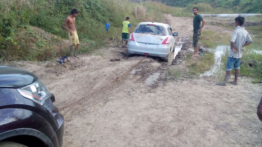
We commenced our drive on a road that would lead us to Thailand (only if we extended our holidays by a fortnight more), guided by Google maps. But for now, it was destination: Haflong, the only hill station in Assam. The under-construction road was patchy every few kilometers, alternating with smooth asphalt and bumpy gravel. At one point, the road with endless stretch of forest cover was so beautiful and intimidating for a photo stop but we were scared for even a pee-stop. We were however, at the mercy of google-Mata’s directions!

The Asian Highway through Dima Hasao

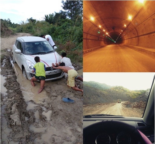
So, the scene what happened after we passed the Mahur cross is documented in another post for you to read. Long story short: we missed a diversion in the under-construction road, continued on AH1 as per google maps and our car got stuck in a deep ditch, in the middle of a forest reserve. We were stranded without help almost until sunset. Finally help and the forest officer’s army, all arrived together to get us out to safe haven. We waited at the officer’s makeshift container workspace until he finished his day’s work and took us to Nothao lodge, a place where our stay in Haflong was arranged at. It was a nice resort (good for a less touristy place like Haflong) but most of all, the owner was a resourceful person who was going to take care of our travel activities for the next couple of days.

Our car being towed by RSA

“Not all who plan and come here get lucky, as the weather plays a crucial role in being able to see it, even after reaching here. The wind direction tonight is very favorable. You are here at the RIGHT time to witness the mass-suicide of the birds. Be ready by around 12.00.a.m., the jeep will come here to pick you all. The officer and I will join you at my house and then we shall proceed to Jatinga.” The Hotelier said before leaving us. We were all excited! After freshening up, we placed an order for a hearty Dimasa meal for supper. ‘Try Local cuisines, wherever you are’ was a mantra all three of us religiously followed. The must try-dishes were recommended by the friendly chef at the lodge.

The poor car had gone through so much abuse on its very first road trip that it deserved a good shower. While the boys drove out to the town to find a good spa for the car, I decided to stay back at the lodge. The wooden furniture in an open dining space with mellow music playing in the background and cold misty breeze from the green trees around, blowing on my face was enough reason for me soak up some inspiration to write my next story. As a couple of hours passed, the boys returned. I don’t know if the car found a spa, but the boys for sure found a bar 😛 They returned with a few liters of judima, the local brew of rice beer.

We were the lucky few who were to witness nature’s phenomena, one so rare that it is unexplainable by science. We had braved quite an adventurous drive to make it thus far… But the weather was such, that I can’t blame them. The two drank up the stock ignoring all my alerts, warnings and requests! It was now nearing 9.00.p.m. and so, blame it on the ambience of the dining area. While the meal was being arranged on the table, the two were dozing away. Jatinga and the birds were all flying away from me now, faintly to the elusive distance 😛 I tried to keep the two up, at least to finish up the meal and not waste it. The two walked up to their room and had passed out within the next few moments. “See you Jatinga, next time!”, I silently spoke while breaking the roti in my hand.

It did not feel right for me to drive into a forest alone with someone whom I barely knew. Hence, I decided to make ‘Nothao’ my destination for the night.
I requested the hotel staff to serve the same food on the following morning (there was SO MUCH food, that neither of us would want to throw it off), informed the hotel owner and the forest officer of my situation and silently slid into the comforting warmth of the rugs in my room.

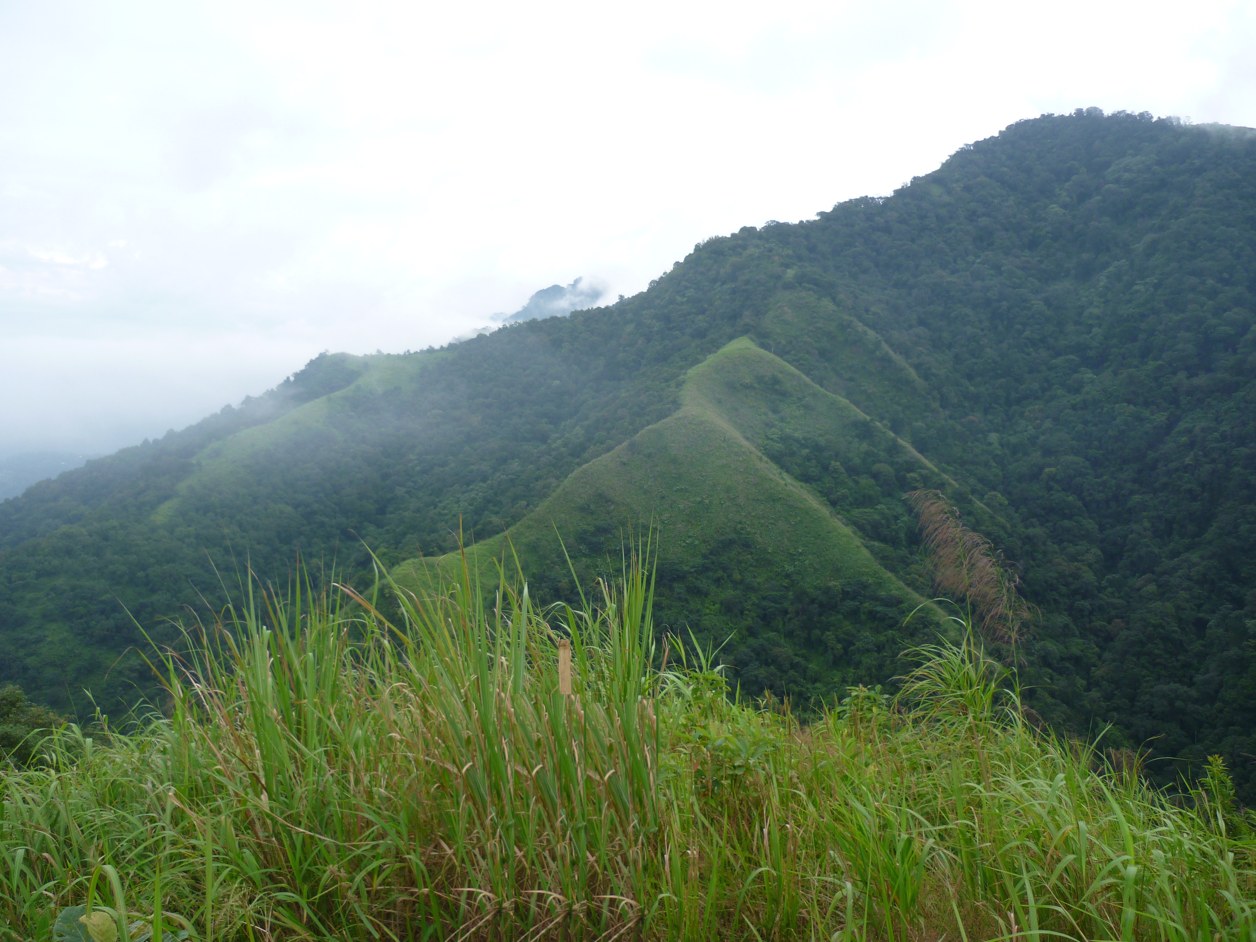
Anyway, the miss was made up for, by the two boys who had been my travel partners for the last 2 weeks (well… partially). We explored a little bit 9f Haflong. The duo spoke to the officer and a hike to the highest peak of Assam- Hapeo peak was organized. That’s yet another story you might want to read here. Thus, happened our misadventure to Jatinga and the last bit on my fortnight in the north-east.

Silicon city to Magnetic fields- Part 2

…. Continued from Part 1

So yeah, the bike is fixed. I am fresh. I remove and keep my sweatshirt in my bag in a way that I can pull it out without having to open the bag. It’s already about 12:30 by now. I set out to cover as much distance as possible by dusk. Well I took Nashik-Shirdi road because that was the shortest distance. Oh boy, shortest distance turned out to be a nightmare. The road is okay for maybe about an hour from Pune; there on, it is more of a fucking off-roading course. The road is literally non-existent for a hundred kilometres atleast, riddled with huge potholes and roadhumps where it is not necessary. One fucking hell of a road! Pretty fortunate not to have crashed on this section because of the unmarked roadhumps. Even in broad daylight, I couldn’t go past 40kmph without risking a fall or ruining my bike. The road pretty much stays the same till Malegaon.

The stretch at Sangamner

I leave Dhule just before darkness prevails. It becomes a very monotonous situation from here. Almost zero traffic after dark and no street lights or illumination for the highway. It is just me, riding alone in the dark, among occasional trucks. I have to ride through Khargath Sendhwa. The Road seemed twisty turvy with occasional potholes and what looked like debris on the sides. I passed a R15 couple here in this section. Without much thought, I continue my journey in the darkness. I did stop once, near what I can explain as a petrol pump- pretty much away from me. Just when I’m stretching my ass off, the R15 guys show up right next to me. They stopped to enquire about my destination and why I’m riding alone. I initially thought I’m about to get mugged, but these guys actually advised me to stop for the night as the journey on this road, at this hour was not safe. And they ride off.. Of that was so not expected, from a stranger..!

Above: Tollgate at Kalghat; Below: Tollgate at Dhule

Well now, I also ride out almost as soon as they left. I next stopped at Khargate tollgate. Here, I had to listen to three people advising me to stop and take the night off because it is not safe to ride alone on this road. Oh okay, now I’m kinda curious and cautious about riding anymore. So, I ride a little further from the tollgate till I find a brightly lit place which had boarding and lodging. I decide to finally take off for the night and catch a shut eye for the ride next day. It’s about 9.00p.m. now. And I take a room that is pretty huge for a single guy like me. All I had to do was to uncloth myself. That was it, I set an alarm for 5.00 in the morning because I can’t wake up any sooner. That’s all I remember. One super deep sleep I was in, as soon as I hit the bed. So peaceful sleep I got, like proper deep sleep…

The alarm went off on time, only to be snoozed till 7.00a.m. because I’m lazy to ride out in the cold. So I finally get off the bed, take bath etc. and ready by 8.00.a.m. I have 2 cups of tea and vacate the place. Remember, I’m still a 1000kms away from my destination.

Photo stop near Gujri

By 8:15 I’m already on road riding out, not till I spot a board indicating a town called Gujri. Oh well Gujri, what better name to have a picture taken with. Just a brief picture stop. Okay.. that’s the last stop major picture stop of the day. The whole day went riding pretty much non-stop, except for the fuel stops. So yeah, I rode and rode the whole day because this was my last day to reach in time. I pass through Dhar, Ratlam, Mandsaur, Neemuch City and Chittorgarh. This Chittorgarh happens to have a massive fort. But for me today, no time. So onward… The whole road has been good wide road, so no tension. But now new tension, I can rain see clouds in the far distance. So I take a brief pitstop to cover my bag and continue.

Nothing much worth mentioning along the route there onwards. However, it’s become pretty late by now. Almost past lunchtime. I ride till I reach Kishangarh. Oh, this place is like Jigani neighbourhood of Bangalore. Only Marbles in this city. This city is filled with marble sellers. Italian, Indian, whatever marble you want you will get it here. A Marble market city. So by the time I leave this city, it is already 5.00.p.m. I drape my blanket and get prepared for the “Thand”. The next city is Kunchaman city. This city seemed a little dirty with slush almost everywhere. Then I realise that it had rained here. It’s kinda wet and cold. So take the road to Jhunjunu via Sikar. This road is good but single lane, no street lights. Almost reached Sikar, when I’m having a tough time riding the bike. Because it suddenly became unbearably cold and was completely covered in fog. Even the other vehicles seem to be driving super slow.
I almost fell off once because of a mound in the middle of the road. I almost immediately stopped, to take stock of the situation. The road was wet because it had rained. Not only had it rained, but it was a hailstorm and the temperature had dipped to near zero. The mounds on the road were mounds of hail stones and I had almost fallen off because of them. Shit crazy it was. Who expects rain in the middle of a desert region? Yeah, so I pass through that area and reach Sikar. Then reach Jhunjunu and finally take the deviation towards Alsisar. This fucking maps can take through some crazy routes if you are not careful enough..!

Hailstones at Sikar

However, it took through some road and put me back on the right road in a while. Yeah peace. . It is 11:30pm and I’ve reached my destination. “Alsisar Mahal“. And I’m all set for the festival. It is cold and I am tired. I had been waiting to just get a place to sleep.

And so yeah, I reached a music festival in just around 50+ hours from Bangalore. To the ‘Magnetic fields ‘ music festival from the ‘Silicon City’ Bengaluru in 50hours..!

To be continued….. Part 3

(Are you enjoying reading this piece this far? If yes, Please subscribe or hit the Follow button to read my stories from the road. If no, please leave your comments below and tell me how and where I can improve upon)

Regards, Lahar.

Silicon city to Magnetic fields- Part 1

So, as the title suggests.. this is about my journey between Bangalore and Alsisar, in the winter of 2019. It is not another bike riding blog that you’d find spamming the internet. This one is a story.. About “HOW” I got there, when reaching the destination was the target. But as things unfolded, I’m writing this today to share my story with you all..

The background:

One day, while scrolling down on my Instagram feed, I come across a post seeking volunteers for the magnetic fields music festival. A festival I have been following for a few years. Given this chance, I filled in the questionnaire on the given link. A few weeks went past and I had eventually forgotten about it… To be noted: I was unemployed or rather occupied with agriculture, until this point..

So in the month of November, 17th to be precise- I applied for a job as a sales consultant at a luxury bike dealership in Bangalore and got employed also. Trust me, this was the easiest aptitude I have ever answered! The test was held in the dealership itself, which had a good playlist playing in the background as I was taking my test. It was more like: I enjoyed my time giving the test.. So, I sailed through that and got employed also. Well, everything was alright but not right.. I was employed at the place for exactly 8 days. Exactly a day before my birthday. The Best birthday gift ever, that was it: I got an employment termination. I was let go because I was not enthusiastic enough. Yeah, right! 100% agreed, I don’t give a damn either.

Post this scene, I’m cycling back home.. Well, that’s when I get a call. It’s a person calling to seek more information about me and my application for volunteering. She called to ask me if was interested and if they could hold a video interview. Oh, well! Why not? All done and now I’m in, as a volunteer…

They call again exactly 7 days before the event, to reconfirm my participation. Done, set I am; Atleast for the event. Not set with how to reach the event… Well I spoke to my parents and tried to get money for my journey tickets. They probably thought I was joking and did not  bother to respond. I did this till the last buffer day for me to leave home to reach the festival venue on time. Even on the last day, I’ve asked but no avail. Well, I’m not good at convincing I guess. I did my mental calculations and came to a decision that given the pace and ticket availability- train was ruled out and plane was fast but extra expensive, considering last minute booking. So, I decided to ride to Rajasthan.. In 2 days flat! Well yeah, I did ride 2200 kms.. in a little more than 48 hours, though.

Today:

I leave home after realizing that it was futile, trying to convince my parents to agree for plane tickets. I packed essentials like one thermals, one pullover, shoes, 3 pairs of clothes and not much cash. I’m full rich you know, only cards.!No one at home is happy about my last minute plans to ride 2000 odd kms with absolute no planning. Most important thing I did was stick my name and emergency contacts written on a paper on my fuel tank, just in case something went off route. Okay, tata, bye bye to home.. For the next 10 days.I leave home at around 4.00.p.m. straight to the service centre. Oil changed, chain lubed and tensioned, all while listening to the workshop supervisor telling me to replace the chain kit and tyres, as both had exceeded their life. Yes, I know they needed a replacement but I didn’t have enough time. Okay, I agreed to his advice telling him that I’ll do it in Pune. My bike was ready, atleast for the night until I reached Pune, just a few hundred kilometres away..05:15.p.m., I start my lonely ride to reach Alsisar as early as possible so as to not miss the reporting, day after tomorrow. So now, I’ve left home just before night fall and I have 2000kms to ride. I stop for dinner at a roadside hotel at about 10.00.p.m., the only hotel that seemed to be brightly lit. There was not a single tea shop the whole time. This first night is nothing much interesting except for continuous  riding all night, till I eventually got tired at about 02.a.m. I was finally tired, enough for a major pit stop in the middle of nowhere. Also, I had underestimated how cold it might be.. Standing cold and riding cold are very different levels of cold.! Had to wear my thermal and my pullover to feel, just warm enough that night. I eventually stopped at a truck lay-by, which are more common than hotels after passing Hubli. This place seemed good enough to stop because there was a bright mast light installed nearby and there was nothing else other than this small bus-stop like truck lay-by. I was tired, so I just decided to lay down on the broken benches.

img-20200816-wa0005-016717414007853295320.jpeg
Getting a power nap at one of the truck lay-bys

My bad, this place sucked! Because, every now and then these sugarcane farmers went by in tractors, blasting music at that dead hours. And also because it is a national highway, every truck and bus whizzed past the shelter making my rest-stop unbearable. I vacated the place in 20mins to find a place that was more silent. I ride for the next hour, till I finally reach Kolhapur tollgate. Being dead tired and partially sleep deprived, I give up riding.. It is probably 3:30-04.00.a.m. Being at a considerably more safer place with constant security, I just pass out on my bike, at the tollgate! I did wake up eventually, feeling just a bit fresh at about 5.00.a.m.Time is running out and I’ve not covered half the distance. Oh shit, I’ll get late. I almost immediately leave. Sometime into the morning ride, I am greeted by a fellow rider on an older red Ducati while he gracefully overtook.By day break, I’m almost in Pune. At 6:30-07.00.a.m., I’m at Khatraj Ghat, full of fog. Well, I ride into Pune and miss the exit I should have taken to enter the city from Swargate. Instead, I happened to take the ring road which bypassed the city and took me through Hinjewadi and Pimpri. Here is when the first balls in my mouth scene happened… I just happened to go past Tata motors at Pimpri and stopped for my morning tea as it is almost 8.00.a.m. now.. I don’t know if it was the tea stop or some inauspicious time of the day; My bike chain seemed to have gotten jammed and was making a very uncomfortable metallic rubbing noise. At this point, I was barely able to ride it.. I got off the bike and started to push it, because the nearest service centre at Chakan was just a few kms away.. Even pushing became difficult as the chain had jammed or become tight. I gave it a thought, then hopped on and rode. It was nerve wracking to listen to the chain rubbing against some other unfigured part… I prayed the whole trip from Pimpri to Chakan, just that the chain doesn’t snap.

img-20200816-wa0002-014840030917362987131.jpeg
Somewhere in Pune

For my good fortune, the chain repaired itself I guess and everything became normal again, just as I neared the service centre. Guess what? I’ve arrived too early to the store. It’s 9.00.a.m and the service opens at 10.00. Good that the showroom guy had just opened. He was cleaning and setting up the store. I tell him to inform me when the service supervisor arrives and pass out on the showroom table, till almost 11.00. Eventually, he did come. This service centre guy gave me the best attention I’ve got. I told him the problem. He however, was not able to verify it because the chain had magically fixed itself. I got it lubed and tensioned again. Trust me, the chain and tyres had become overused by now. I tell him my destination and he was surprised. He also repeated the same, what I had heard in Bangalore. “Change your chain set and tyres, or you’re not going to make it back to Bangalore..!” I give him my assent to do it in Jaipur.

Click here to continue reading: Part 2

Bhaderwah- the Mini Kashmir of Jammu

Snow-capped mountains, lush green meadows, pine trees, tulip gardens, skis and snow boards… Do these things paint a perfect picture of a state known for its valleys? If you guessed it to be J&K, Yeah, you’re right! To be more precise, did you guess it to be Kashmir valley? If you did, then you can’t be more wrong. I’m talking about the least talked region of the state: Jammu.

For those who have heard little about Jammu, the mention of scenic or adventure hotspots comes as a surprise for all they know is only its religious places, the most popular being the Vaishno Devi shrine. For tourists visiting this region, there are several lesser-known destinations around Jammu city that are as beautiful as its popular counterpart in the Kashmir region. But, continue to remain unexplored and Bhaderwah being one among them. Bhaderwah is a town located in the Doda district and is called as ‘Mini Kashmir’ by the locals. This nickname itself gives a fair picture of the beauty of this place.

Places to visit in Bhaderwah:

• Day trip to Bhaderwah town covering Vasuki Nag temple, Gupt Ganga temple, Bhaderwah fort, Tilligarh rose garden and Gatha lake resort
• Jai Valley trek
• Sonbain glacier trek
• Kailash Kund terk
• Peer ki pindi (camps of Akbar) trek
• Seoj Dhar Meadow trek
• Day trip to Chattargala Pass
• Day trip to Sarthal valley
• Day trip to Basohli

The Details:

There are several attractions in Bhaderwah to mesmerise all genre of travellers who visit here during any time of the year. Bhaderwah is also called as ‘Nagon ki bhoomi’ (land of snakes) giving one a sense of its connection with mythology. Vasuki Nag is believed to be the keeper of Bhaderwah and hence the temple dedicated to this snake lord holds significance in the local culture. Thousands of pilgrims participate in the annual ‘Kailash Kund’ yatra that starts from the Vasuki Nag temple. The highlight of the temple is the idol of the presiding deity that is carved out of a black stone and is standing at an inclination. The temple is nestled within the narrow lanes of the town that snakes through ancient and traditional wooden houses from the time when the valley was ruled by the kings of Bhaderwah and Chamba. The town’s association with Mahabharata too can be felt at the ‘Gupt Ganga’ temple, on the banks of river Neru. The Pandavas are believed to have lived here during their exile. The Bhaderwah fort situated atop the town gives a good view of the entire region.

The Gupt Ganga river bank

The annual Tulip festival, Tilligarh rose garden and Gatha lake resort are some nice places for a day’s outing. Trekkers seeking to explore some breath-taking vistas can hike up the Jai Valley, Sonbain glacier, Kailash Kund, Peer ki pindi (camps of Akbar) or Seoj Dhar Meadow and connect with nature. If you are an adventure buff, the Jammu tourism has put in great efforts to cater to this segment with various outdoor activities like rafting in the Chenab river, rappelling, rock climbing, parasailing etc. Since Bhaderwah witnesses high snowfall, its high valleys are a great place for winter sports like skiing and snow-boarding too. It is slowly catching up as an alternate to Gulmarg in the state.

The Bhaderwah fort

Dirt roads and numerous water crossings in the region don’t fail to keep the adrenaline rushing for bikers who choose to ride here. The biking enthusiasts can opt the road through Padri, the highest motorable road in this region. Chattargala Pass is the highest motorable road and the most untouched point in Bhaderwah and offers a 360-degree spellbinding view of the entire region. It connects Bhaderwah with Basohli, another town of historical importance. One might be lucky to spot the endangered white vultures at this point or even some musk deer or Asian bears after a short hike up the hills.

One of the river and waterfall crossing on the way to Baderwah

The road to Basohli is picturesque with meadows, streams and typical pine trees all along the way. Sarthal valley is one of my favourite pit-stops along the way. With nothing much to do, it is beautiful with its laid-back scenery with Bakarwals (Shepherds) settlements amid green meadows and gushing streams from the glaciers. The seven-tiered waterfall located here is worth a short trek before riding up the treacherous road towards Basohli town. Basohli town itself is beautifully located on the backwaters of the Ranjit Sagar dam flanking it.

With political unrest being rampant in Kashmir, the main source of income through tourism has taken a huge toll in the state in the last couple of years. Jammu is very safe for all kinds of travellers and the tourism department is putting their best efforts to familiarize tourists with the other unexplored areas of the state. If visiting this state has long been on your bucket list and the unrest at the borders has kept you away, I think it is time you relook into your plan to visit the Mini Kashmir instead!

Fact file:

  • Getting there: Jammu is well connected by airport, rail and road. You can hire a self-drive car or a taxi from the city to visit the other sightseeing places. Bhaderwah is 280kms(about 5hrs) by road from Jammu city.
  • Stay: TRC (Tourist Reception Centre) guesthouses run by the J&K tourism dept., several homestays and budget hotels are available. Tilligarh tourist complex is a great place for one seeking luxury in nature.
  • Must try: Sip a cup of ‘Desi Chai’, a pink coloured tea that can be consumed either with salt or sugar.
  • Must buy: Basohli miniature paintings.

This visit to Bhaderwah was a part of our ‘Peace ride’, sponsored by Jammu tourism as a part of the Himalayan expedition to promote tourism in the lesser explored places of Jammu. The route we covered over the week was Jammu-Mansar-Basholi–Sarthal–Baderwah-Kishtwar-Gulabgarh-Sansari-Gulabgarh-Patnitop-Udhampur-Jammu. It has been over a year since this trip has been past and yet remains one of the best so far.

A biking expedition in the Himalayas

When my name was included in the list, I had a bag of mixed feelings. I was glad to have got an all sponsored trip to one of the least explored parts of the country. But at the same time, I had my apprehensions about being a part of an organized trip. I was excited to travel on one of the deadliest roads in the world and then the fear of being a misfit as a pillion among what was supposed to be a biking event with professional riders from across the country kept flashing frequent thoughts of pulling-out of the event! And finally the evening arrived, where we had to start our journey towards Jammu Tawi- The start-point of all the action filled seven-memorable days of my life!!!

No one knew the other fellow rider at the start, but during the course of time- each one ensured they stopped, waited and helped the next one in times of need. Reaching the destination on time did not matter to anyone; they would halt and wait when the rider behind went out of sight in the rear view mirrors. Whether it was running to lift up a rider who slipped on the slush pool or to push one up the steep valley roads when the machine refused to move… whether it was picking up a fallen silencer of a rider who has gone way ahead without noticing or going back to get tools from the back-up vehicle to fix a broken bike.. Whether it was escorting a rider whose headlamps and brakes had given way while riding at night on the treacherous Paddar Valley or towing a halted biker all the way on a militant infested highway… And then, on the last day when I had a miraculous escape from death while trying to avoid overriding on a biker who slipped off-his-course, the entire battalion of riders had stopped by to check on my sprained leg! No fights, no misunderstandings, no quarrels- It ain’t a common thing while you are traveling with a group of over 80 riders from across India who were all strangers. But, they were all united and stood by each other at every turn (literally!!) of life during these 7 days…

Doctors, scientists, engineers, lawyers, were all just educational qualifications. While some made it after a nasty tiff with their bosses, yet a few had quit jobs to do this trip. While some rode to satiate their hunger for travel, some rode to earn livelihood for their towns through promotion of tourism. While some came to make few quick bucks with their photos and videos, yet a few came to love the mountains… Yet, a few rode to spread the good word of beautiful landscapes, safety to travelers and cultural wealth of their hometown which otherwise is perceived with horror and poverty. Every rider had a purpose to travel and a story to tell that’s associated with this trip. Irrespective of the geographical, cultural and educational differences- Travelling was the common religion and riding was the only God… No one big, no one small. No one to judge who you are… For a person that I am who otherwise likes to go slow, walk and take in things and places at my own pace- riding only meant whizzing past things with speed… What I realized during these 7 days is that there lies a whole new perspective to life out there- Biking binds people like brothers… Cheers to all the wonderful friends I made here, who helped me to create truck loads of wonderful memories that I can cherish for several years to come…

The route we covered over the week was Jammu-Mansar-BasholiSarthalBaderwah-Kishtwar-Gulabgarh-Sansari-Gulabgarh-Patnitop-Udhampur-Jammu. It was a complete package with picturesque landscapes accompanied with art, history, culture, religion, natural resources, adventure, offbeat traveling. It had something for every kind of traveler. I strongly recommend this trip for every person who wants to travel but do not like going to the commercialized and overly crowded places that are so done and dusted. This stretch is a must-do once in a lifetime thing!

I will be posting details of each day and each place that I visited in separate posts in days to come. Do subscribe and get updates 🙂

This trip was a part of ‘The Peace ride’ to explore the lesser known places in Jammu and was sponsored by Jammu tourism.

Hiking up Assam’s highest point- Hapeo peak

This post is part of my fortnight long road trip across North-east India, specifically covering parts of Meghalaya – Assam – Arunachal Pradesh I had tagged along with two other travelers and drove around the places in a self-drive car hired at Guwahati. We had arrived at Haflong, the only hill station in the state of Assam following a mis-adventurous trip. (Click here to know the details)

This trek to the highest point in Assam happened by chance, as a backup after the original plan for the day had failed. We were told that the hill isn’t yet popular in a typical tourist’s circuit. Apart from the local tribal folk who like to party atop the hill, hardly 4 to 5 trekkers come here from outside the district and the state to climb this hill each year. Having said that, we wanted to reach Hapeo peak, the highest point in the state of Assam for sunrise. However, due to the clouds that had hovered that morning, we decided to snooze for a little longer before going ahead with the plan.

There are totally 13 native tribes in Dima Hasao district of Assam state and each tribe has its own village. A local NGO called spectrum is working towards the empowerment of the local tribal communities through promotion of tourism in the district. They helped us in getting this event organized. We were driven in their 4WD vehicle from Haflong to a village called N.Liekung. N.Liekung village belonged to the Kuki tribes and the required permits from the village head was arranged by Spectrum. A local guide was assigned to take us through this off-beat wilderness to scale the highest point in Assam. I would like to present my trek in essentially three parts.

Part 1: The Ascent

After a small stop in front of the holy Cross at the prayer area of the Kukis, we began our ascent towards the peak. For the three of us, all seasoned trekkers doing this trip together, the climb to Hapeo peak wasn’t a very difficult one as compared to what we had done back in the Southern India. But what made it seem difficult was the high grass that had grown tall enough to cover the entire stretch. Since the trek is not frequented with people, the grass on the path is not worn out as much as in the popular trekking trails. Hence, the way up was something through which we had to FIND the trekking trail. Based on the ease of finding the trail, I would split the trail into three portions:

  • A well traceable path with steps laid. However, at some places, the stairs have been lost amid the thickets. We had to cut the grass and bushes in order to find our way. The stretch was full of high grass with occasionally placed animal traps which our guide who walked ahead, would carefully move aside and make way for us.
  • This was the only flat area with some grassland vegetation for a stretch of around 500mts.This was the only place apart from the highway, from where we could actually see the peak that we were apparently scaling up!
  • The last part passes through thick jungle, with a canopy of trees that allowed very less sunlight to penetrate. Varieties of innocent looking wild mushrooms had bloomed at several patches, but we were warned not to pick any of them as they could actually be lethal with allergens or venom. We were accompanied by strange sounds and cries of migratory birds around.
p1140545
The only grassland in Hapeo trek

As we climbed up while chatting up with our Kuki guide, he enlightened us with their tribal customs, culture and showed us a few videos on his phone of their traditional dances, festivals ceremonies and the like. Our guide jokingly told us how his fellow folks are named in the tribe. The names may not mean anything and just anything random that sounds nice goes as a name. He was thus randomly called after a ‘Song that was Sung’ (I’m sorry, I don’t want to give out his name). But the tradition is, that the maternal grandfather selects a name for the granddaughter and the paternal grandmother picks a name for the grandson and vice-versa. It is a patrilineal system of inheritance.

Part 2: Reaching the Top

Suddenly, the darkness of the jungle had turned into snow white of the clouds. Before we could realise, we had reached the top already and we had barely taken us two hours. We were told that one could see the entire district of Dima Hasao from up there. But, we were greeted with thick fog and clouds upon arrival. We spent some time soaking in nature’s beauty and waited for the clouds to clear so that we could catch a glimpse of the beautiful view.

For the benefit of potential trekkers, there is just one small shelter with a bench atop the hill and nothing apart from yourself there! Our guide mentioned to us about a patch of land measuring about 2×2 feet, right behind the bench where a natural and strong magnetic force is believed to exist, due to which none of the mobile phones work in that spot. Yes, we tested the phenomenon too. Although all our phones had FULL network, we were unable to place any calls. But none of us had any scientific reasoning for what he told.

p1140551
A view of Dima Hasao district from Hapeo peak

In the next fifteen minutes, the clouds had slowly started to clear. We spotted the railway bridge at Lumding onto the right side of the horizon. This rail line is the longest and highest in the Silchar route. Our guide pointed towards another hill onto our left, through which the longest railway tunnel (around 3.5kms long) in the North-east passes. The Silchar-Lumding railway route has been featured in several tourism websites and has been one of the scenic stretches in the country. As the weather slowly worsened and began to drizzle, we decided to start our descent.

Part 3: The Descent

When we had just started to climb down and we received a call from the NGO. We were told to return to the base of the hill ASAP as an alert for a cyclone had been issued by the meterological department and heavy rains were expected in this region in the next few hours. But, it had started to pour cats and dogs within no time. The fastest pace we could catch was by rolling down the hill. With all the rain, thick grass covered path and steep gradient, just a steady walk itself was a struggle as we descended on the slippery trail. There was nothing enroute to take shelter from the rain. But, waiting at any place made no sense because the pounding rains would continue for the entire day or even two. It made more sense to simply continue to walk down as we were already drenched till our bones.

We were back at the base by 11.00.a.m. and thus ended our trek to the highest point in the state of Assam. We were invited over to our guide’s house to dry ourselves up and have a cup of hot tea. We thanked him much and bid adieu with a warm heart to this lesser known corner of the world!

A mind numbing winter experience in Ladakh

So well, thank you for dropping by. This post is an elaborate impromptu itinerary we came up with when we were stranded in Leh, sometime before Ladakh became a separate Union territory. If you’d are interested in planning an itinerary, stick around this post. But, if you’re keen to know the fun story behind our plan going haywire, I recommend you to also read my brother/ co-traveller’s perspective. (Click here to read his story)

Stick around a little more, to know my side of the same story. Then tell me what you liked 🙂

Here’s mine!

What was supposed to be an once in a lifetime experience of trekking on a frozen river- ‘The chadar trek’, rather turned out to be a wonderful experience in its own way.. Thanks to a landslide on the Zanskar, a natural dam had been formed stocking up water for over 5 kms. If incase this natural dam collapsed due to the built up pressure, the stored water would wash away the nearby areas causing flash floods. Hence, citing safety reasons, the goverment had issued ‘section 144 – Shoot at sight’ to anyone attempting to go anywhere close to the river.

We decided to break away from the trek organiser and explore Ladakh on our own.. Oh yeah, before I forget to mention- None of our phones were working(No connectivity via phone or internet)- Thanks to all our pre-paid connections. Only postpaid connections work in this part of the country due to security reasons (given its proximity to disputed border areas). Thus started our lifetime experience of the mind-numbing winters in Ladakh.

Day 1: It was noon by the time our early morning flight took off from Delhi airport, thanks to bad weather conditions. Just 20minutes after take off, a small but prominent layer of cloud seemed to appear at the horizon.. But within no time, we realised that we were approaching the Himalayas. In just few minutes, the GPS indicated Shimla on the map in the TV infront of our seats. A never-ending stretch of deep gorges, ravines, formed the beautiful landscape below. Few minutes further up.. Yes..!!! we couldn’t contain our excitement of flying over the snow covered mighty Himalayan peaks, we were jumping for a spot at the windows taking turns.. It was the first time we were seeing snow! Click click click…. The cameras went on and on… It was as if we were in an enclosure which was floating up in heaven.. It was absolute FEAST to the senses.. all the way… till touch down🙂

You are flying over the Himalayas...
You are flying over the Himalayas…

Inspite of the glaring bright sun, it was 6 below zero degrees when our flight landed at Leh- one of the highest airstrips in the world. We took a cab to the hotel that we were informed by the trek organiser.

The day went by just making an alternative plan for the trek that could not happen. Also, it was necessary to get acclimatized to a scary combo of High altitude + low temperature(It went upto -25deg on some days of our trip). So we just had to stay bummed to our rooms(without heaters..!!) and warmup ourselves 😛 We shopped for a lot of thermals in Leh market (we got cheap & good quality stuff..)

Day 2: It was the last day of the Gustor festival – the annual fair at the Spituk monastery– Enroute we visited the ‘Hall of fame‘- the war museum. We happened to be there at the right time when an Indian airforce carrier was about to land. With the Sham valley & other mountain ranges all around the airstrip, it called for the exact photo that had inspired me to visit Ladakh more than a year ago.. We later headed to the monastery where the day long festivities and mask dance was going on.. We walked up the stairs to the holy abode of Kali(which is open for public viewing only during Gustor festival) before we comforted ourselves by finding a seat amid the chaotic crowd that had assembled. After the event, we did a bit of souvenir shopping at the mela that was put up and a lot of binging on Ladakhi food. We took a cab to Shanti Stupa which is best for sunset viewing. After the sun was down, we took the stairs down which we were told was a shortcut to reach Leh town by foot.

Mask dance at the Gustor festival - the annual fair at the Spituk monastary
Mask dance at the Gustor festival – the annual fair at the Spituk monastery

Day 3: Drive through Changla pass(the 3rd highest pass in the world) at a nerve freezing temperature: Get a quick grab of food at Karu town. Here one needs to get the Inner Line Permit to proceed towards Pangong Tso- the controversial border between India & China. The lake was partially frozen- where we could drive over most part of it and experience the chadar partially 😛 If one has an extra day, they could head to Tso Moriri, a salt water lake and camp there overnight before returning to Leh. But, we took back the same route so we could cover the Shey Palace, Thikse monastery & got a glimpse of the Rancho school of the ‘3 Idiots’ fame. Hemis monastery- the wealthiest monastery in India remained unreachable by road since it was winter.

A milestone at the Pangong tso

Day 4: It was a lonng day.. A wonderful drive on a roadless route which seemed to have been carved all out of ice and sprinkled with snow.. A small slip of tyre could get deadly as beautiful as the valley seemed to appear. We couldn’t ask for more when it began to snow just when we alighted at the end of the highest motorable road in the world- the Khardungla pass. Continue on the road that leads to the cold desert of Ladakh- The Nubra valley. With minimal vegetation, and sand dunes all around, you should not be missing out the ride on the Bactrian camels which are endemic to this region and is a critically endangered species. Visit the Diskit monastary- where a 32 feet statue of Maitreya Buddha looks upon Pakistan. Towards the end of the valley is the Siachen glacier- the highest battleground in the world and the glacier forms the source to the biggest irrigation system in the world-The Indus. Catch a good night’s sleep at a traditional homestay there and experience authentic Ladakhi hospitality.

View from a monastary
View from a monastery

Day 5: Start early cuz the day will be short with too many places to cover on a single stretch from Leh. We took the Kargil road- a drive through Sham valley. First stop was at Nimmoo where we filled our fasting tummies. The next quick stopover was at Pattar Sahib Gurudwara. The straight stretch of road looked as if it was peircing right through the horizon. We were driving through the magnetic hill. The road which is believed to have defied gravity where a car with ignition off and neutral gear moves uphill- against gravity..!! We were not quite convinced with our experience though, which made us agree to the scientific explanation of it being an optical illusion. We arrived at Chilling- The confluence of the Indus and Zanskar. The partially frozen stretch was intimidating to walk over.. But we were warned by a cop not to go near the banks.. all thanks to section 144 😛

The confluence of the Indus and the Zanskar

We continued our journey through rustic Ladakhi villages, monasteries dotting the distant hillocks, frozen waterfalls, bare poplar trees, narrow truss bridges, army barracks, hot water springs, ice hockey fields, etc. We came across wild deers, yaks, pashmina sheep, wild horses and other fauna endemic to this high altitude region.. Likir monastery was beautiful with the Buddha statue smiling in between the snow clad mountains all around. Our last destination was Lamayuru monastery– The start point for many treks in this region.

Unfortunately, we did not have the luxury of a few more hours and safe conditions at the border to go further upto the Kargil border. We wanted to drive back through Drass valley- The coldest inhabited place in India and the second coldest in the world. Again, If I had an additional day in hand, I would have loved to get an inner line permit to spend a day at DhaHanu valley: home to the endangered community of the Dard people. I would love to go back ASAP atleast to document their customs, traditions, photograph their intricate jewellery and costumes before their numbers further deplete. Had I been blessed with a couple more days, I would want to do the Markha valley trek andand experience the tribal life in its raw & purest form.. And spot a snow leopard in its natural habitat at the Hemis national park- the largest national park in India and the highest national park in the world.

During winters, most of the town is shut for the season. The few places that are up, open after 11.00.a.m and close by 5~6.p.m. We missed out on some fine shopping of souvenirs, local handicrafts and dry fruits.. Probably, some form of connectivity of phone or internet could have helped us to cover more places and organise our trip in possibly a better way.. But, NO REGRETS..!! We’ve still done what most people don’t dare to- Experience the bitter winter of Ladakh. That’s all the time we had for.. We had to pack our bags with a super heavy heart to carry back home..

Day 6: It was a rare phenomenon that we had woken up with that day, early at 6.a.m. It was snowing in Leh. There usually is no snowfall at Leh town… But that day I guess the town had started to miss us… the sky was crying heavily.. We reached the airport by 07.30.a.m. The security measures are very stringent for those leaving Leh which easily needs about 2hrs. 2 rounds of passengers’ frisking and 2 rounds of baggage screening. And then, you have to individually identify your baggage until which it will not be loaded to the flight..!! Quite a strenuous task for the security personnel… While it is considered as a fun trip for the touristy people like us.. It’s a salute to the bravehearts : The Indian army.. Who bare all odds like extreme climatic conditions and unpredictable threats to their lives, strive day and night to ensure that we are safe.. The flight took off over the mountainthat said ‘Touch the sky with glory’.. in the true sense…

I will come back ASAP for more..

Julley Leh..!!