Tag Archives: Grand canyon

Natural wonders of South India – My favourites

India has intrigued the world with its history, geography and culture- each individually dating back to several ages ago. I have been no different from the rest of the world. The LostLander has begun to embrace her landings after getting lost at random places in her incredible country. The more she is exploring her country, the more she has been discovering about its descendance and getting mind blown with new discoveries each time.

“The history of India’s physical geography is older than that of its civilization or even that of the human race. The subcontinent has been a distinct geological entity for millions of years. Therefore, to understand India, we must go back to the very beginning.”

-Sanjeev Sanyal

The fact that it is called as a subcontinent is associated to a larger theory of it being separated out of a supercontinent called ‘Rodinia’ and drifting apart from Africa, Antarctica and then Madagascar before it struck with the Asian continent. No, I’m not time traveling that far for now! It was just to put an exclamation to how amazing this country’s geography has evolved to be and what the natural bounty as we called it, has to offer in this beautiful country to an explorer… To take my article forward and with no biases, I divide the geography of this subcontinent into North and the South, just by drawing an imaginary line passing through its center, Seoni in Madhya Pradesh. Here is a humble attempt to take my readers through some of the beautiful destinations I have been to enjoy the natural marvels of Southern India. They are in random order and listed as and when I recollected them. For more details, you need to read my individual posts on them by clicking on their respective tags!

1. Kurusudai islands: Nestled off the coast of Rameswaram in the Gulf of Mannar, it is the only place in the world where the oldest and the last surviving living fossil is found in the world.

2. The table tops of Maharashtra: Be it the beautifully painted pink valleys of the Khas plateau, valleys of Matheran, Mahabaleshwar or any place thought of for a scenic drive for the Mumbaikars- have all formed out of large volcanic eruptions as the subcontinent merged with Asia. Not just that, these geographical features were strategically used by Shivaji to stop the invasion by the Mughals and hence called the Deccan traps.

3. Limestone caves of Andhra Pradesh: Belum caves, a part of a larger cave complex in the Erramalai region is the largest and longest cave system that is open to public. Similarly, the Borra caves is the deepest in the country. The speleothem formations are worth a visit which have formed due to continuous flowing of water over a thousand years, easily dating back to the Archaean age.

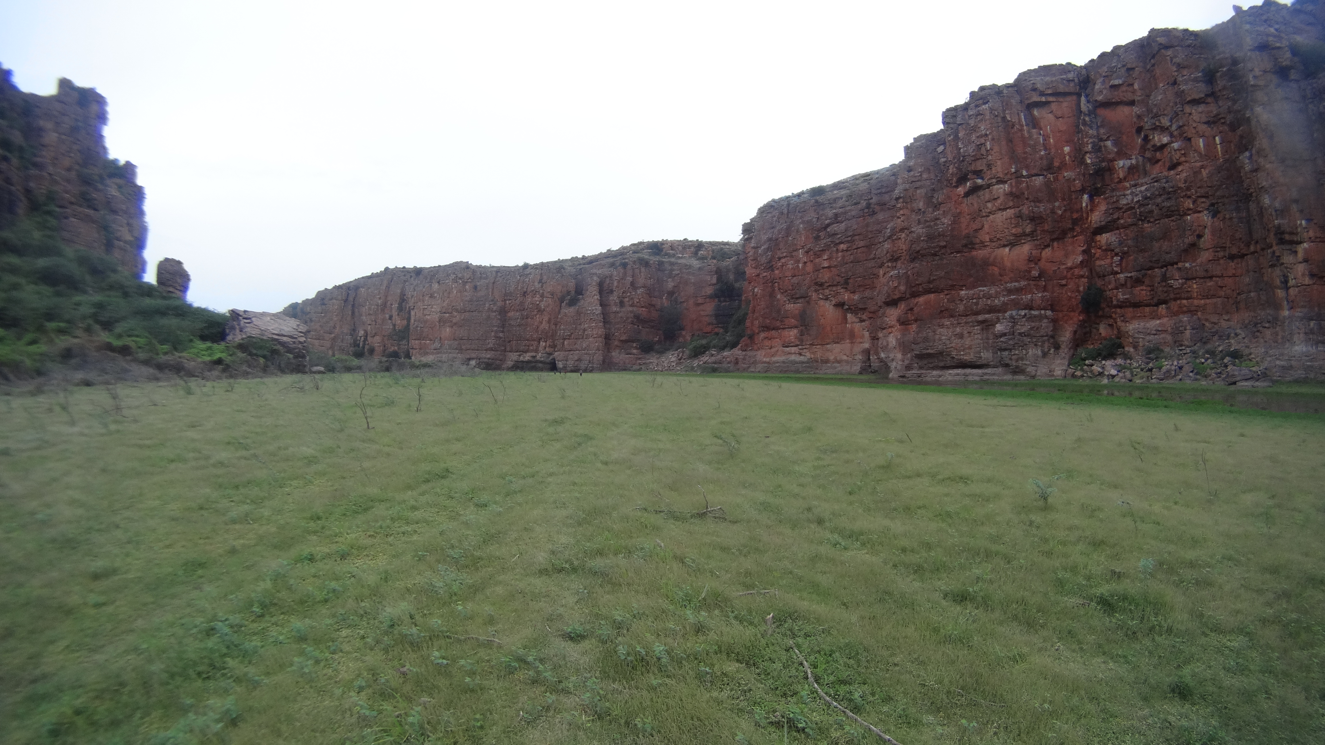
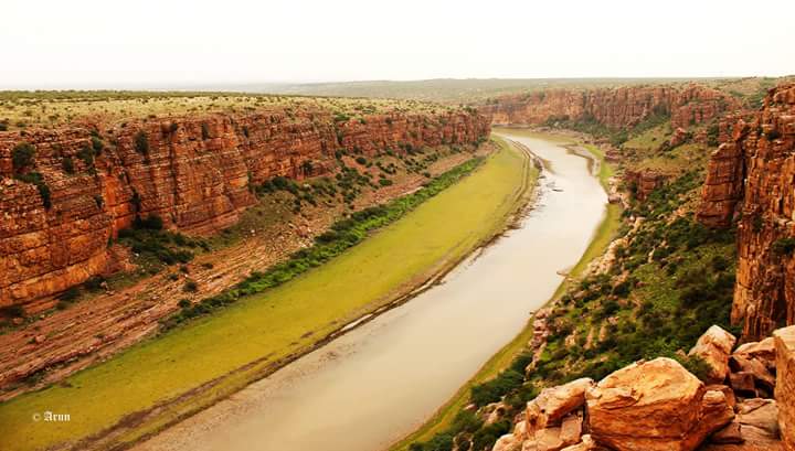
4. Gandikota: People call it as the ‘Grand Canyon of India. It is a beautiful gorge formed by the Pennar river as it squeezes from between the rock formation that has played witness to several kingdoms in history.

5. Eastern Ghats: Although I use a very generic term that specifies an entire region, they are older and mineral rich than their popular counterparts on the western side. All, again a resultant of several tectonic activities in the event of formation of the Indian mass.

6. Dhanushkodi: This abandoned town has more than just history of a cyclone. The revered ‘RamaSethu’ or the Adam’s bridge was formerly considered to be the largest Tombolo in the world and is believed to have formed due to the drifting of India and the Lankan land masses several thousand years ago..

Well… If all these have been the outcomes of several tectonic activities of the earth over a million years, there are yet several other amazing things that nature has to offer in the Southern peninsula.

7. Have you been to Wayanad in Northern Kerala? There is a heart shaped lake after a good climb up the Chembra peak in the western Ghats. It’s the nature’s way of telling ‘I Love You’!

8. Heard of the Barren island? It is the only active volcano in India, with the most recent eruption being in 2017. The sea area around it is considered to be one of the best dive sites in the world!

9. And then there is Baratang islands- It is the only mud volcano in India, situated in the Andaman group of islands.

10. Have you seen the Purple hills? Where do you think the Nilgiri hills in the western Ghats derive their name from? They’re so called because these green verdant hills are painted blue/purple (Neela in Hindi) by the Neelakurinji flowers, something that blooms only once in twelve years. The latest mass-blossoming being in 2018.

11. Cruised through the canals of Kuttanad? Mostly popular among the honeymooners and families alike for its backwaters and houseboats, what many don’t know about this region is that it is the only region in the world where paddy farming is done below sea level.

12. How about a boat ride in the Mangrove forests of the Bay of Bengal? The Sundarbans and Pichavaram forests are the first and the second largest mangrove marshlands in the world. A world heritage site that they are, an extremely important part of the ecology.

13. What happens when a meteor hits the earth? A massive crater is formed giving form to Lonar lake in Maharashtra. This Geo-heritage monument saline soda lake is the only high velocity impact crater lake on earth.

14. Seen the waterfalls of the Deccan plateau? Be it the Chitrakoot falls in Chhattisgarh, Gokak falls in Karnataka, Athirapally in Kerala or Hogeynakal in Tamil Nadu… They’re all so good they can give a good competition to the Niagara!

15. Heard of the Sentinelese tribesmen in the Andaman sea? They’ve long avoided contact with the outside world and their gene pool is believed to be one of the crucial links to early man and the evolution of mankind on the planet.

What India has to offer is abundant! And these are only a few places that I have been to in the southern India. Do you have any recommendations? Have I missed out on anything? I would LOVE to know… Please drop n your suggestions, recommendations, feedback in the comments section below 😊

Marvel at Caves and Crannies- Kurnool

A trip that was pending since over two years, finally took wings last weekend. The places covered were an unusual combination of natural and contrived elements that created beauty. Had the both not been there, the existence of these places would have a lesser value than what it is today.

Our Itinerary:
Friday night: Drive from Bangalore
Saturday: Yaganti group of temples, Banaganapally Nawab’s bungalow, Owk reservoir, Belum caves, Sunset and night’s stay at Gandikota.
Sunday: Explore Jammalamadugu fort & Gandikota, Lakshminarayanaswamy temple in Kadiri town, Lepakshi and reach Bangalore by late evening.

The details:
An overnight drive was aimed at starting our trip from Bethamcherla- a town in the Kurnool district of Andhra Pradesh. A couple of articles on the internet had caught our interest to visit this place which is a treasure trove for archaeological studies. Invaluable Pleistocene remains have been excavated from several caves that are scattered around this region. We wanted to explore the Yerrajala & BillaSurgam caves in particular after being impressed by the photos online. However, even after talking to several localites, we failed miserably to get anywhere close to the places we were looking for. Language was a BIG concern there and for any small enquiries too, the curious people would throng in large numbers and stare at us while we were trying to communicate with our hand signs. Luckily, we had a Telugu-ite in our group who would do most of the talking throughout the trip. So without really finding the place, the day started somewhat on a low note.

As per the plan, the first day was a long one with target being to reach Gandikota for sunset. In quest of the place, we had already lost 3 hours doing nothing. So, we decided to skip Yerrajala and proceed to accomplish the rest of the itinerary. The winding roads of Tadipatri are carved out of the rocky hills. These hills are rich sources of the infamous Kadapa stones used in constructions. Its sedimentary rocks formed over years can be seen in layers, which make driving along this stretch a delight! We stopped at several spots to photograph the beautiful landscape as we drove through, to reach our next destination- Yaganti.

This is an ancient cave temple patronized by the rulers of the Sangam dynasty. ‘Keep left’ is the rule one needs to bear in mind in order to cover all the caves located around. Here, every cave has a special story to tell. Just keep taking the stairs whenever & wherever you spot them, so that you don’t miss out on any cave. At a point, a flight of steep stairs takes you to Agastya Cave where Lord Shiva is worshipped. And yet another chamber leads you to Lord Venkateshwara. Although, the lord is otherwise known for all the wealth, the minimal deco and the dimly lit chamber here, has some positive energy that emanates out of the place. We needed a little more time than what we had initially thought we would need to observe this place, where art, history & mythology co-exist.

PICT_20160709_094820
The temple pond at Yaganti- amidst a backdrop of several caves

On our return, we halted at Banaganapally village, in front of a mansion that stands magnificently atop a small hillock, by the road side. An old rusted name board read- ‘Nawab’s bungalow’. Though the exteriors have stood the ravages of time, the interiors of this imposing structure built of wood and rock, is crumbling. In spite of being featured in several movies, nobody really knows who the Nawab who owns this bungalow is.

Further into the drive, we stopped by for a quick group photo at the Owk reservoir. We were ‘literally stopped’ while we were trying to capture a photo with the serene backdrop of the dam. The wind blew so hard that we were struggling to move against the strong currents and felt stationary most of the times. It was my first time experience, of ‘fighting’ the wind. I really wonder how strong a ‘storm’ could be..!!

Having found NO hotels for breakfast, it was a hungry drive down until Belum village. After wandering around, we settled down to have lunch at the only A/C- restaurant in the region (with no electricity for A/C service) on a recommendation by a localite. Not like we had an option either..!! After a quick lunch, we drove over to Belum caves.

As expected, the weekend crowd was insane. But, the weather was in our favor on that breezy afternoon! On a flat/potent fertile land that seemed fit for cultivation, there appears a deep well like opening in the land. A steep flight of stairs takes one by surprise, as he enters the infamous caves. The magnificent stalactites & stalagmites formations of limestone make Belum caves the longest and the 2nd largest complex in the country. Several ancient remnants of pre-historic human dwellings and relics of the Buddhist era have been discovered, marking the caves on the map of archaeologically and culturally important places. Due to the crowd, high humidity levels and low level of oxygen inside, most of us had a severe headache by the time we walked out of the place to sunlight. But whatever the hardship, it was totally worth every drop of sweat.

DSC02269
Inside the Belum caves

We were running behind schedule and we had to zip, zap, zoom… to reach the sunset point… After a 2-3 hrs drive, we were excited to spot the windmills dotting the distant horizon. The long wall of the Jammalamadagu fortress stood spread across, bordering the land’s end. It was an indication that we were approaching our destination- Gandikota.

But the sunset..??? Hell yeah! We did make it in time, but the clouds played spoilt sport! Never mind, we still had chores to accomplish before it was dark. We wanted to trust the roads and go where they took us. That’s why, we hadn’t booked our stay. In worst case of not finding a hotel, we had carried tents and sleeping bags as backup. The trip had been good so far and we hoped that all went fine till the end… As expected, the rooms were all occupied at Haritha- The only stay option around, for miles (A resort run by the AP tourism). We negotiated with the caretakers to let us use the washrooms and dining facility.

We struck a deal with a couple of villagers and then hiked down the steep gorge to pitch our tents for the night. It was really dark and well past 9.00.p.m. when we started our descent down to the river ridge. The descent seemed longer than expected, with the luggage and the total darkness of the night adding to our woes. A few loose stones rolled down our feet as we paved our way down carefully. Once we reached the bottom, it was immense silence that had engulfed the calm environment and our ‘cubicle bred minds’. The fresh cool air filled our souls. It had been a windy day throughout, and the night by the river side could’nt be any different. We managed to pitch one tent with great difficulty and the rest of us decided to just cuddle inside their sleeping bags. The weather wasn’t harsh and the cool temperature remained pleasant, right till dawn. The only thing we were hoping for was, that no dam gates were opened for that night and that we all don’t get washed away in the dark 😉

DSC02312
That’s the view from our tent- from the Pennar river bed

We all were awakened by the first rays of dawn and opened our eyes to a dream… We all knew we were camping on the ridge of river Pennar all night. But only with sunlight, we realized that we were actually sleeping on the ‘river bed’!! No wonder that, the soil felt moist and loose while we were struggling to pitch our tents last night!! With the mighty gorge standing all around us, our hearts skipped more than a few beats at the splendid view of the painterly beauty. We strolled across the river bed till both ends of the fort wall, taking in sufficient clean air into our lungs through the billowing winds and the burnt yellow-green grass. We returned to our tent, cooked maggi and ate bread-jam for breakfast. Soon, we had to undesiringly call it ‘Pack-up’, lest face the brunt of the burning sun while climbing back with the entire load.

Once on top, we explored the view point, the old mosque, the fort remnants, the granary and the temples in the village. The entire village exists within the fort walls. It was a beautiful place to bid good bye!

The Pennar gorge at Gandikota Photo credits: Arun Kumar B.R.

For a pious traveler, a visit to the Lakshminarayanaswamy temple in Kadiri town and the Madhvarayaswamy temple at Gorantla is recommended. Both from the Vijayanagara era, would complete their religious trip. Half a day could be well spent at the Lepakshi complex too, if opted for on the way back to Bangalore. We opted out of these temple visits and drove back to Bangalore through the bypass road. In this route, we travelled mostly through protected forest reserve area which was another highlight of our journey. The Rollapadu bird sanctuary, the only habitat in Andhra for the largest flying bird in the world, the endangered – ‘Great Indian Bustard’, lays just a small deviation away. The mighty rocks balancing on each other and the greenery all along just made every bit of the trip so joyful.

We had to reach Bangalore to drop a friend at the airport for her late evening flight! Thus ended a quick weekend… like zip, zap zoom…!!!

A Day Out At Mekedaatu

It was after a long-time that we cousins were catching up and so we planned to have an all cousins day out (no aunties, uncles, mammas and Pappas). We narrowed down to visit Mekedaatu for the weekend. At 10.00a.m on a Sunday morning, we were late to leave home to any tourist places around the city. And to add to our woes, it was Banashankari temple’s annual festival that day. This only means that we had to wade through hopeless traffic jam along with the Kanakapura road metro line construction also being underway…!!

List of places covered:
Food stop at Vasu hotel, Kanakapura- This is popular for its crusty Masala Dosa
Chunchi falls
Sangama
Mekedatu viewpoint

Details of the trip:

Six kms before Mekedaatu, a board pointing to the left indicated the way to Chunchi falls. We decided to take the deviation. The summertime visit to Chunchi falls was a disappointment for us after reaching there. There was hardly any water in the river and the rocks shined bright in the sun’s reflection. Just as we were about to turn our backs to return, a localite who was around us started a conversation with us. He eventually told us that he could take us to a better viewpoint. We blindly decided to follow him.

We crossed a small dam, a ridge and continued to walk. after a tiring walk in the scorching sun for about 1.5 kms, we slowly started to grow suspicious as to where this man was taking us as the place started to look more secluded. But, just then, he pointed at a watch tower and told us that we could get a good view from there. Before we could react, he intruded – “But, you need to walk down there. Behind that bush”. We were like, “OK… hmm huh…!!” and continued to walk further. He would certainly not be able to mug us as we outnumbered him, we thought. Once we reached that spot, it was a total sense of relief and a surprise. Had we returned earlier; we would have missed such a great spot. I’m sure this place would look more amazing in the monsoon season.

Chunchi falls
Chunchi falls

After spending a while at the falls, we thanked the old man with a goodwill amount and headed towards Sangama. ‘Sangama’ is a confluence of river Kaveri and Arkavathi and supposedly a very scenic spot post monsoon. But disappointment was waiting for us again after reaching there. Insufficient rains and the influx of tourist on a weekend, the place was crammed with very little place to even sit peacefully on the riverbank.

Legend has it, that a goat had jumped across a gorge to escape from a chasing tiger and hence our destination derived its name in Kannada. (Meke = goat; daatu = cross). Trekking the 3 kms distance from Sangama to Mekedatu was banned then and hence, we had to wait for the pick-up bus to come. After disappointments back to back, we were apprehensive of going forward till Mekedaatu wondering if it would be worth our visit. We lost our patience in waiting and walked across the shallow waters to reach back to our car. The security guard who had been observing us, walked up to us and suggested that we go to Mekedaatu since we had already come so far from the city. We were still half minded and tossed a coin. Heads said a ‘Go’.

The view around Sangama

After disappointments back to back, we were apprehensive of going to Mekedaatu wondering if that place would really be worth our visit. Trekking the 3 kms distance from Sangama to Mekedatu is banned now and hence, we had to wait for the pick up bus to come. We lost our patience, and crossed the shallow waters back to reach our car. The security guard who had been observing us, walked upto us and suggested that we go to Mekedaatu since we had already come so far from the city. We were still half minded, and tossed a coin. Heads said a ‘Go’.. So we again crossed the river, by then the bus had returned. We got the last seat for ourselves. The bus was a total-out-of-the-junk-yard-thing. The seats we were sitting on were infact tied to the roof rails with strings- more like a swing..!! And the fully crammed bus(packed to twice its capacity) started. It was an unpaved road, and a lot of dust was filled inside the bus which made us literally stand up from those swinging seats..

View enroute to Mekedaatu from Sangama

So, we again crossed the river and by then, the bus had returned. We got the last seat for ourselves. The bus was a total-out-of-the-junk-yard-thing. The seats we were sitting on were in fact tied to the roof rails with ropes. It felt less like a bus seat and more like a swing…!! And bus was fully crammed and packed to twice its capacity. The drive was through an unpaved road, and a lot of dust was filled inside the bus. We could barely breathe inside and all we stood up from those swinging seats. Once we reached Mekedaatu after a strenuous back seat ride, we felt that the security guard was right- It was a nice place. But again, insufficient rains did not give me the internet picture I wanted.

Since our onward ride was a bad experience, we chose to sit on the top of the bus for our return. Trust me when I say that the ride was the highlight of our entire day… The best bus ride we all ever had in our life. The bus went at high speed blowing the dust high up from the unpaved roads. There was just one thin steel rod around for us to hold onto, that too was tied to the windows below. At one point, another bus came in the opposite direction, and our bus went completely off road. It felt as if our bus was balancing on a few small stones on the slope of the valley so that the driver could make enough space for the other bus to pass through the narrow road. We could reach the treetops, see the best views of the river and the valley below. It was one AMAZING ride.

The bus, road and our shadow of sitting on the top of the bus- between Mekedatu and Sangama

We ended up feeling that the return trip was a very short one and wanted more… one adrenaline rush moment it was…!! It was the last ride for the day as the sun had already set and we returned to our homes high on energy and all charged up and motivated for another boring week ahead.

There are a lot of options around Kanakapura for a full day or half-day trip. I have covered these places on separate occasions. A few of them are:
* Kabbala Durga trek
* Bheemanakindi trek
* Pyramid valley meditation center