Tag Archives: Mahabaleshwar

A weekend Backpacking trip to Satara

This was a post monsoon, weekend trip I had planned with two other friends who had joined me from Bangalore to Mahabaleshwar. The main agenda of this trip was to visit the ‘Khas plateau’ in its bloom season, but it was just for a day (Click here to read more about my visit). Since we were travelling all the way, we decided to extend the weekend for a little longer by adding a few other places and make it a backpacking trip around Satara district.

Our Itinerary:

Day 0: Leave from Bengaluru to Satara (overnight private bus)
Day 1: Satara to Wai (MSRTC bus), Visit to Menavali village & Dhom Dam; Wai to Panchgani (Local bus), Local sightseeing and night’s stay at Panchgani (Walk and shared taxi for local transportation)
Day 2: Panchgani to Mahabaleshwar & local sightseeing at Mahabaleshwar (hired taxi for full day); Mahabaleshwar to Satara (MSRTC bus) and night’s stay at Satara.
Day 3: Visit to Khas plateau & local sightseeing at Satara town (hired taxi); Return from Satara to Bengaluru (overnight KSRTC bus)

The details:

Day 1: Wai and Panchgani.

Since we required to start our Khas plateau visit from Satara, we decided to visit the places around the town later (on day 3). So, we moved ahead on the day of our arrival at Satara.

After alighting at Satara bypass on NH4 that morning, we hired an autorickshaw to reach the bus stand located in the town. From there, we boarded a MSRTC bus to our first major destination of the day: Wai.

Part 1: Places to see in Wai

I had come across the name of this place in a newspaper supplement. I had read that a large part of Shahrukh Khan’s “Swades’ movie was shot in and around Wai. Since we had to anyway pass through this place to reach our intended destination of the trip, I thought it was a good idea to add Wai it our itinerary. However, we had no idea of what to see and things to expect in Wai. We decided to just go there and explore the place by ourselves. Upon our arrival at Wai, we enquired with a few locals who guided us to the banks of the Krishna river.

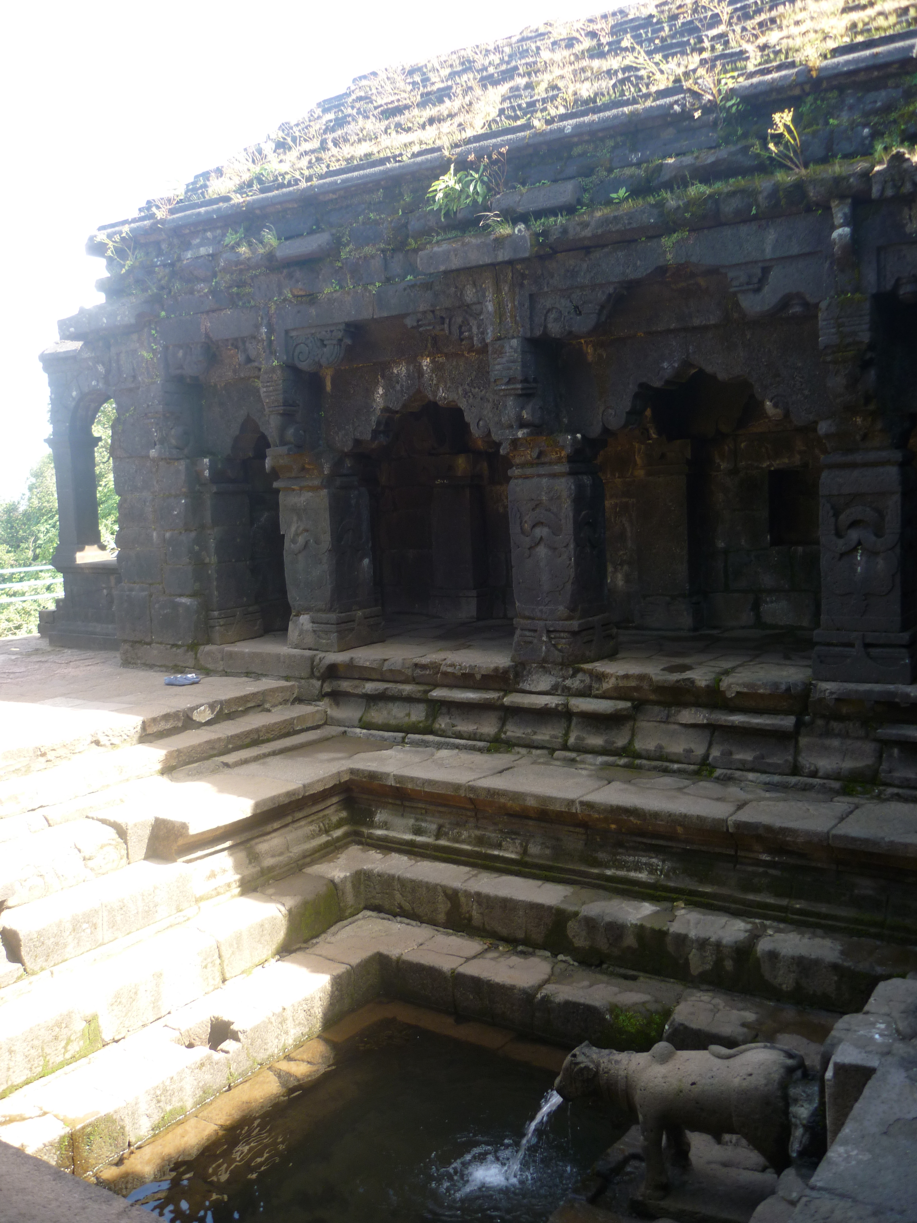
A. Menavali village: A walk of good couple of miles from the Wai bus stand, we arrived at this village located on the banks of river Krishna. The locals call this as the Wai ghat as well. Apart from being a prominent setting for several Bollywood movies, the Wai ghat is also an important destination for history and archeological buffs. It holds great treasures from the times of the Marathas and the Peshwas. It is especially known for the contributions by the 18th century Maratha stateman- Nana Phadnavis.

Phadnavis Wada: Wada is a local name for a residential mansion with an inner courtyard. Residential complexes leading to river banks on one end and housing temples is a signature architectural style of the Peshwa era. The Phadnavis Wada located on the Wai ghat is one of the handful of such structures that still remains intact.

We did a quick visit to the Dholya Ganapathi mandir & Sri Kashi Vishweshwar Mandir (This temple is called as the Kashi of Maharashtra), both situated on the river bank.

Wai ghat on the banks of river Krishna at Menavali village

As we took a stroll along the ghat, I realized that reality was far from the destination on reel. The real Wai looked very laid back and rustic. However, we decided to sit by the riverside and spend some time by photographing the local kids enjoying their time by diving and swimming in the polluted waters of the ghat.

B. Dhom dam: This waterbody is a good place for water sports with a nice view of the surrounding mountains. Located at about 10kms from Wai and connected by frequenting local shared jeeps, it is a nice place for catching a sunset. But, we gave this is a miss since we hadn’t booked our accommodation and has to reach our next destination ASAP. The bus left Wai and travelled around the curvy road of the mountain. The entire journey was beautiful with great views of the Dhom dam whose waters reflected the clear blue sky.

Part 2: Places to see in Panchgani

We had alighted at our next major destination: Panchgani. Although Panchgani is a small hill town that doesn’t extend beyond a stretch of 2 kilometers, surprisingly, it is an educational hub of Maharashtra. Around 42 international schools are located here. Given its small area, all the popular tourist places in Panchgani are located close by. So, we decided to get off with our backpacks at the entrance of the hill station, explore the landmarks and then find a place for our stay. The details of our time in Panchgani is as given below:

a. Harrison’s Foley view point: This is the first major landmark you come across, even before you actually enter the town. However, we thought of giving it a miss because our next stop was going to give us a view of this Foley as well.

b. Sydney point: We got breathtaking view of the Dhom dam from here. After a long day travelling and walking with our backpacks, we thought this was just a perfect place for us sit down and soak in some relaxing views. We sat down right there on the footpath, facing the dam and spent some peaceful time amid nature. After spending some good time and having all our limbs relaxed, we walked back towards the main road.

c. Table land: Our actual plan was to check-in to a hotel and sleep early that evening. However, we changed our minds and decided to visit the table land to use up our time in the remaining daylight. Sometimes, even with no plans, god really wants you to be at the right place at the right time. That’s how this evening turned out to be. As we went up the road leading to this place, it looked like quite a mela up there. There were so many makeshift shops set up and the place had been littered all around with plastic bottles and wrappers. But, as we walked past the maddening crowds, we saw that the table land was a vast stretch than expected. We decided to walk the entire land before dark. The grassland was naturally gifted with vast stretches of native flowers: all white, purple and yellow. It was a magical place that got us busy photographing the silhouettes of the grazing cattle, the horse riders etc. against a beautiful backdrop of the setting sun. An artificial lake amid the grassland added romance to this place. The sky was painted in all hues with a beaming full moon reflecting in the lake’s water, adding to the spectacle. It felt like as if the sun had gone down sooner that day. With that, we had to scoot out of the place as area suddenly started to feel deserted and had no guiding lamps to the main road.

d. Rajapuri caves: This place falls on the way up to the table land. We were told that the cave has a temple dedicated to lord Ayyappan and hence, women of menstruating age are not allowed inside. With that, we headed back to the town and checked-in to a hotel.

We wanted to have some food that are a must try in Panchgani. So, we dumped all our luggage in the hotel room and set-out to walk around the town, yet again.

  • Panchgani is famous for channa, chikki and fudge: the shops say this all over the place. So. we picked up some of these to carry back home.
  • What caught our attention was a bottle of strawberry wine at a wine store.
  • The day’s events concluded with a sumptuous spicy hot ‘veg Kolhapuri with roti‘ for dinner.

On the following morning, the idea was to be at the table-top for sunrise. However, we snoozed the alarm for a little longer and we woke up only when the hotel staff rang the doorbell. We then started our day with a yummy plate of Poha for breakfast and hired a taxi to our next destination: Mahabaleshwar.

Day 2: One day at Mahabaleshwar

The hill station is a favorite haunt of tourists from the nearby metropolis and afar. Mahabaleshwar can be broadly classified into two parts, the New and the Old. Both have been explained in detail in a separate post as the list of things to see and do in Mahabaleshwar is going to be long.

Kate's point and the elephant head view point at Mahabaleshwar
Kate’s point and the elephant head view point at Mahabaleshwar

Day 3: Satara and Khas Plateau

This day was the sole reason that had got us to plan this entire trip. We woke up early to reach Khas plateau for sunrise and get some wonderful photographs. Being early gave us the benefit of avoiding the scorching sun and also to escape the crowds that would normally pour in at a later time.

Apart from my visit to Khas plateau that requires a separate post, I am listing the places of interest around Satara town for those wishing to explore this region:

a. Around Khas plateau: If you have sometime in hand, you can drive further from the Khas lake to reach the boating village of Bamnoli and take a boat tour to Vasota fort or Tapola.
b. Vajrai and Thoseghar waterfalls: These picturesque places were a disappointment when we arrived there as these are mainly rainfed cascades.
c. Chalkewadi windmill station: Considering that we had visited a windmill station earlier, back in our home state and to save time, we gave this place a miss.
d. Forts for the history buffs: Sajjangad, Ajinkyatara, Pratapgad, Kalyangad are places that can all be covered, but only with the convenience of having own transport. We skipped our visits since we were largely dependent on public transportation and taxi service that was expensive.
e. Natraj temple: This ancient structure located in the center of Satara town, is worth visiting

The Pink balsam carpet at Khas valley

Food to try in Satara:

  • Kandi peda: This is a specialty sweet of this region
  • Zunka baakri: This is roti made of a locally available variety of maize, we had it for a late lunch that kept us filled throughout our return journey.
  • Fresh strawberry with cream in Mahabaleshwar.

We boarded a bus back to Bengaluru and thus, ending a long weekend in Satara.

Natural wonders of South India – My favourites

India has intrigued the world with its history, geography and culture- each individually dating back to several ages ago. I have been no different from the rest of the world. The LostLander has begun to embrace her landings after getting lost at random places in her incredible country. The more she is exploring her country, the more she has been discovering about its descendance and getting mind blown with new discoveries each time.

“The history of India’s physical geography is older than that of its civilization or even that of the human race. The subcontinent has been a distinct geological entity for millions of years. Therefore, to understand India, we must go back to the very beginning.”

-Sanjeev Sanyal

The fact that it is called as a subcontinent is associated to a larger theory of it being separated out of a supercontinent called ‘Rodinia’ and drifting apart from Africa, Antarctica and then Madagascar before it struck with the Asian continent. No, I’m not time traveling that far for now! It was just to put an exclamation to how amazing this country’s geography has evolved to be and what the natural bounty as we called it, has to offer in this beautiful country to an explorer… To take my article forward and with no biases, I divide the geography of this subcontinent into North and the South, just by drawing an imaginary line passing through its center, Seoni in Madhya Pradesh. Here is a humble attempt to take my readers through some of the beautiful destinations I have been to enjoy the natural marvels of Southern India. They are in random order and listed as and when I recollected them. For more details, you need to read my individual posts on them by clicking on their respective tags!

1. Kurusudai islands: Nestled off the coast of Rameswaram in the Gulf of Mannar, it is the only place in the world where the oldest and the last surviving living fossil is found in the world.

2. The table tops of Maharashtra: Be it the beautifully painted pink valleys of the Khas plateau, valleys of Matheran, Mahabaleshwar or any place thought of for a scenic drive for the Mumbaikars- have all formed out of large volcanic eruptions as the subcontinent merged with Asia. Not just that, these geographical features were strategically used by Shivaji to stop the invasion by the Mughals and hence called the Deccan traps.

3. Limestone caves of Andhra Pradesh: Belum caves, a part of a larger cave complex in the Erramalai region is the largest and longest cave system that is open to public. Similarly, the Borra caves is the deepest in the country. The speleothem formations are worth a visit which have formed due to continuous flowing of water over a thousand years, easily dating back to the Archaean age.

4. Gandikota: People call it as the ‘Grand Canyon of India. It is a beautiful gorge formed by the Pennar river as it squeezes from between the rock formation that has played witness to several kingdoms in history.

5. Eastern Ghats: Although I use a very generic term that specifies an entire region, they are older and mineral rich than their popular counterparts on the western side. All, again a resultant of several tectonic activities in the event of formation of the Indian mass.

6. Dhanushkodi: This abandoned town has more than just history of a cyclone. The revered ‘RamaSethu’ or the Adam’s bridge was formerly considered to be the largest Tombolo in the world and is believed to have formed due to the drifting of India and the Lankan land masses several thousand years ago..

Well… If all these have been the outcomes of several tectonic activities of the earth over a million years, there are yet several other amazing things that nature has to offer in the Southern peninsula.

7. Have you been to Wayanad in Northern Kerala? There is a heart shaped lake after a good climb up the Chembra peak in the western Ghats. It’s the nature’s way of telling ‘I Love You’!

8. Heard of the Barren island? It is the only active volcano in India, with the most recent eruption being in 2017. The sea area around it is considered to be one of the best dive sites in the world!

9. And then there is Baratang islands- It is the only mud volcano in India, situated in the Andaman group of islands.

10. Have you seen the Purple hills? Where do you think the Nilgiri hills in the western Ghats derive their name from? They’re so called because these green verdant hills are painted blue/purple (Neela in Hindi) by the Neelakurinji flowers, something that blooms only once in twelve years. The latest mass-blossoming being in 2018.

11. Cruised through the canals of Kuttanad? Mostly popular among the honeymooners and families alike for its backwaters and houseboats, what many don’t know about this region is that it is the only region in the world where paddy farming is done below sea level.

12. How about a boat ride in the Mangrove forests of the Bay of Bengal? The Sundarbans and Pichavaram forests are the first and the second largest mangrove marshlands in the world. A world heritage site that they are, an extremely important part of the ecology.

13. What happens when a meteor hits the earth? A massive crater is formed giving form to Lonar lake in Maharashtra. This Geo-heritage monument saline soda lake is the only high velocity impact crater lake on earth.

14. Seen the waterfalls of the Deccan plateau? Be it the Chitrakoot falls in Chhattisgarh, Gokak falls in Karnataka, Athirapally in Kerala or Hogeynakal in Tamil Nadu… They’re all so good they can give a good competition to the Niagara!

15. Heard of the Sentinelese tribesmen in the Andaman sea? They’ve long avoided contact with the outside world and their gene pool is believed to be one of the crucial links to early man and the evolution of mankind on the planet.

What India has to offer is abundant! And these are only a few places that I have been to in the southern India. Do you have any recommendations? Have I missed out on anything? I would LOVE to know… Please drop n your suggestions, recommendations, feedback in the comments section below 😊

Strawberry heartland of India- Mahabaleshwar

This post is a follow-up on my 3-days backpacking trip to Satara. If you haven’t read it already, you can do so by clicking here. I had backpacked across Satara district covering Satara town – Wai – Panchgani – Mahabaleshwar – Khas plateau – Satara town

In this post, I have tried to share details of my day trip to Mahabaleshwar. The place as such, doesn’t needs any special introduction. This hill station is a favorite haunt of tourists from the nearby metropolis and afar. While its stunning views of the surrounding Sahyadri mountains and Deccan traps attracts the weekenders in large numbers, it sees a large footfall of Hindu pilgrims as well. Mahabaleshwar can be broadly classified into two parts, the New and the Old. I started my day trip to Mahabaleshwar from Panchgani on a Sunday morning. I have tried to explain my Mahabaleshwar trip in detail through this post.

Part 1: New Mahabaleshwar

This part of the hill station is popular for its breathtaking sceneries of the western Ghats or the Sahyadri mountains. It was mainly popularized as the summer capital by the British. The table top mountains were strategically used by the Marathas for holding up enemies. Today, it is especially popular among the honeymooners and millennials as a short getaway from the nearby cities.

With many good viewpoints falling on the way, the 15kilometer stretch from Panchgani to Mahabaleshwar calls for many pitstops enroute. We stopped in the following order of places.

a. Parsi point: that gives a view of the Dhom dam from a different direction than what we had been seeing all through the previous day.

b. The Lingmala & Bhilawar waterfalls: These places weren’t as appealing as the case would have been with a good monsoon season.

c. Mapro garden & chocolate factory: This is the venue of the annual strawberry festival and one can see the chocolate making process at the factory through a glass wall. We tried shots of different juices & crushes they offer at the factory and picked up some bottles and chocolates as souvenirs from our trip.

The Mapro strawberry garden and Chocolate factory

d. Kate’s point: It was a pleasant drive amid the Koyna forest reserve to get here. The highlight for tourists visiting this valley is the echo point and the elephant’s head / Needle hole point. From here, we caught a beautiful view of Dhom dam, Balkawadi dam, Krishna valley and the Kamalgarh fort.

e. Savitri point: We drove through the forests hoping to sight a few peafowls, deer etc. but had no luck. Our visit to Savitri point was disappointing because the entire valley had been engulfed by mist. Since the entire valley was filled with mist even at peak noon-time, there seemed no signs of it clearing out.

Kate's point & the elephant head
Kate’s point & the elephant head

f. Castle rock, 3 monkey point, Malcom point, window point, tiger spring, hunter’s point, echo point and Arthur’s point: These are view-points in the same valley, but now enshrouded by the clouds. We only walked past all these spots without being able to see even the faces of the people standing next to us. In fact, this very valley was what had inspired me to plan my trip to Mahabaleshwar. The view of these deccan traps / table-top mountains had mesmerized me through several Bollywood movies that had been shot here. However, that visit was a matter of bad luck.

g. Marjorie and the Elphinstone points: The drive through these places too meant only disappointment.

Part 2: Old Mahabaleshwar

This part of Mahabaleshwar spikes up the interest of the history buffs and those that are culturally or spiritually inclined. Several ancient temples are dotted here amid the serenity of the Krishna valley. Some of the important landmarks are listed below:

h. Panchganga temple: This is the place of origin for 5 important rivers in the region, namely Gayathri, Savitri, Koyna, Venna and Krishna. The five rivers conflux underground and then spout together through the mouth of a cow carved out of a stone about 4500 years ago.

i. Mahabaleshwar temple: This temple dedicated to lord Shiva is accessible from the Panchganga temple, after a small walk through the shopping lanes. This temple is what gives the hill station, it’s name. The legends mention about Atibaleshwar and Kotibaleshwar also, but those are temples that are lost.

j. Krishnabhai temple: A further walk of about 100 meters from the Mahabaleshwar temple led us to an archeological treasure that remains untouched by mainstream tourists. The stream of water spouting from a Gomukh (the mouth of a stone sculpted cow) in this 13.C.E temple is believed by a few to be the origin of river Krishna. Situated almost on a cliff, the place offered a great view of the Krishna valley around. For those familiar with ancient architectural styles, this temple is a good example of the Hemadpanti style of temple architecture.

The Krishnabhai temple

k. Venna lake: A popular and a beautiful place otherwise, we decided not to stop here when we arrived there. The place was maddening and crowded with tourists.

l. Other places of interest in Mahabaleshwar: On a clear day, one could plan to see the sunrise at Wilson point that is known to be the highest part of Mahabaleshwar and Sunset at Bombay point. Both viewpoints are part of the Sindola hill.

NOTE:

  • The entry and exit to Mahabaleshwar is only between 06.00.a.m. to 06.00.p.m. as it is a protected forest area. So, it is required to plan your travel or stay at Mahabaleshwar accordingly.
  • This hill station contributes to 80% of the total strawberry produce of India. Hence, it is safe to call it as the strawberry heartland of India. DO NOT miss to eat fresh strawberry with cream for dessert after a nice Maharashtrian lunch at any of the restaurants in the Mahabaleshwar market.