Tag Archives: Kanakapura

Hiking to a massive natural arch- Bheemanakindi

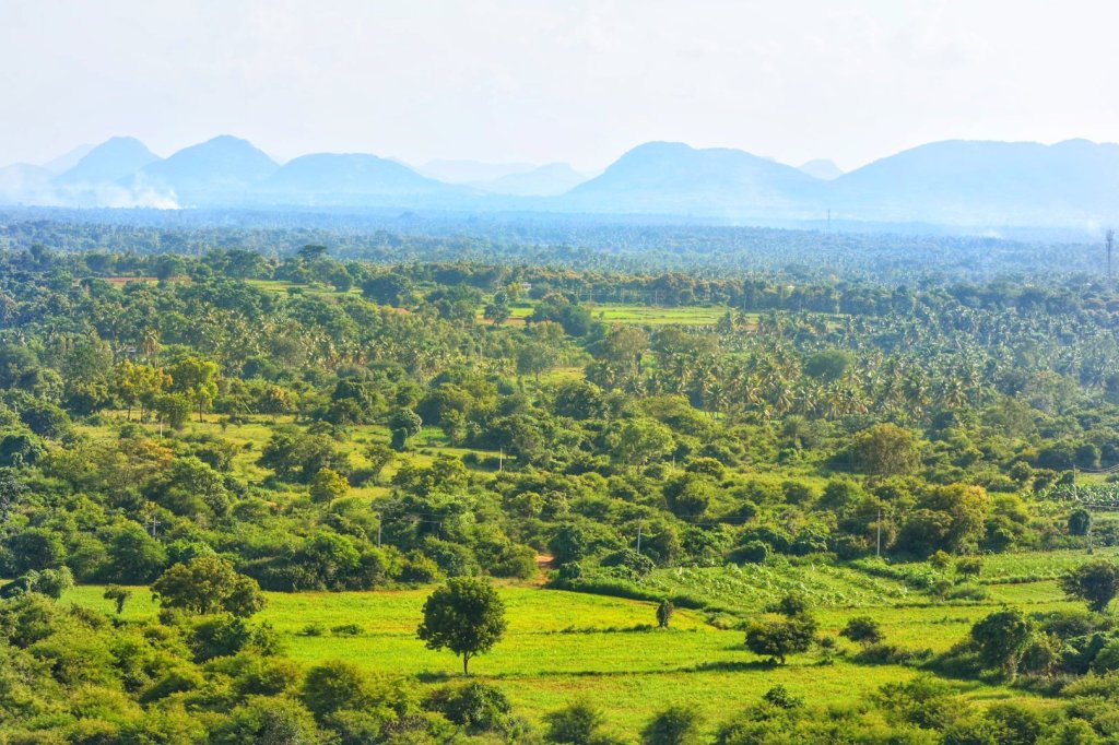
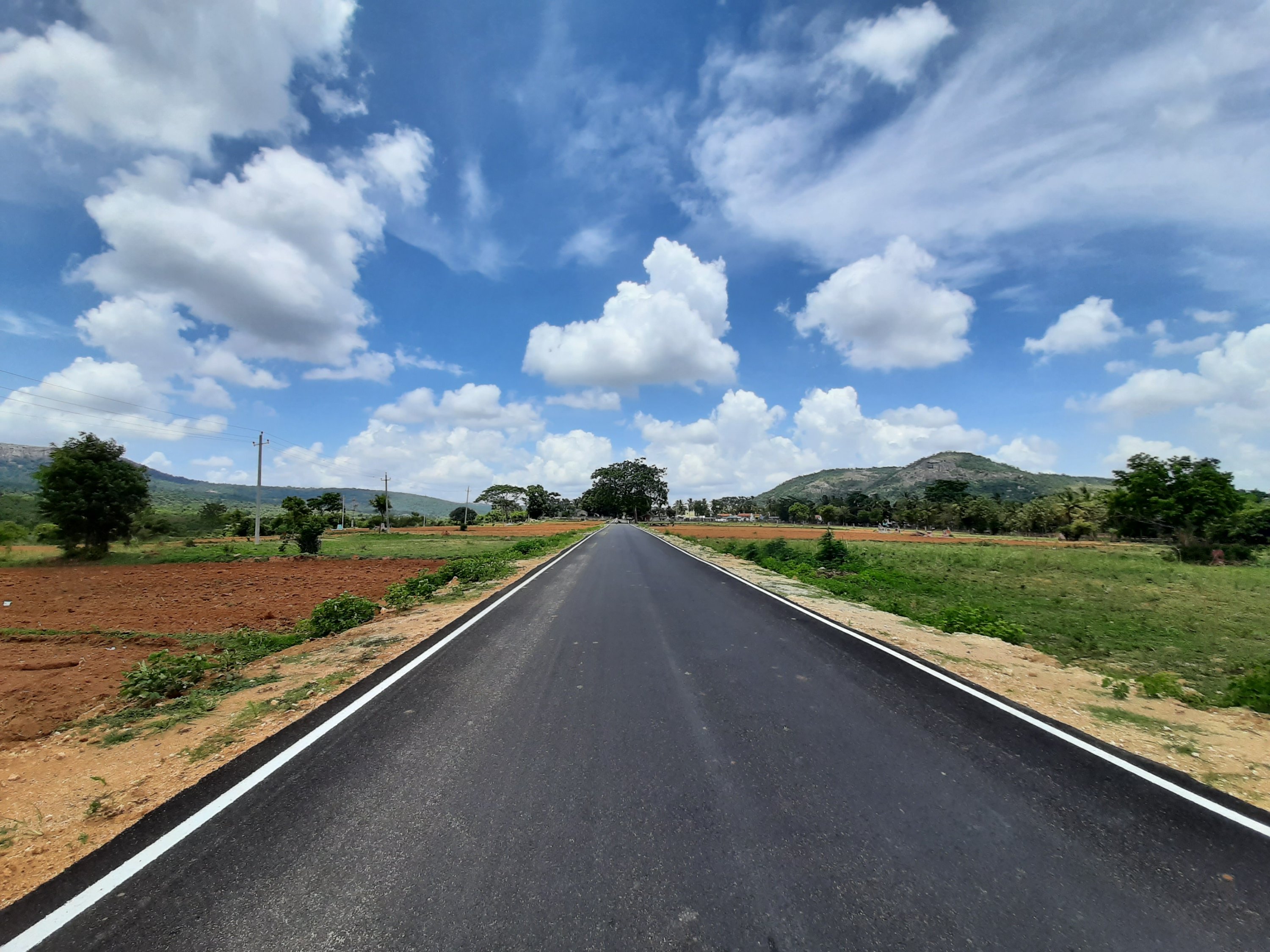
With a closed group of family and friends, about 10 of us planned this weekend trek to this lesser known hill, a little away from Bangalore. We started from Bangalore at 05.00.a.m. with an intention to finish the hike back down before the sun goes up. It was dawn by the time we drove towards Kanakapura and reached a village called Kanchanahalli, in Malavalli Taluk of Ramanagara district. The Kaccha road thereafter till the base of the hike, passes through fine landscape and traditional village of ‘Mysore Karnataka’ region. The hill is a part of the ‘Kabbala Forest reserve’ area. The early morning rays added extra charm to the cloud kissed peak of the ‘BheemanaKindi hill’ at the distant end and the fog covered coconut groves and vibrant green farms on either side of the road. What else? Picture this: A dozen peacocks dancing in the middle of the road! Well, a pleasant welcome; I must say 😊

The Drive and trek to Bheemanakindi

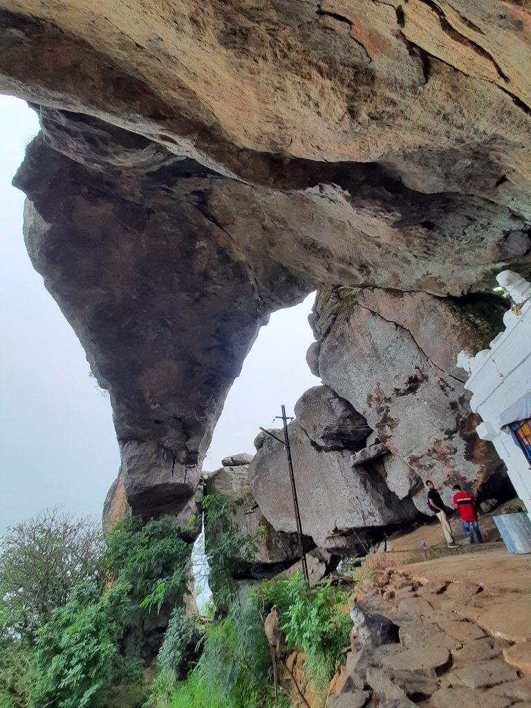
We finally arrived at the base of the hill, parked our cars and started the ascend. It starts at a small godown sort of a structure from where, is a well laid out stone path through the forest, right till the destination. Well, let me clarify that unlike most of the common treks around the city that promise you a breathtaking view after a good climb, this one has a MASSIVE stone arch at the end. With this large arch, goes the legend from Ramayana. ‘Bheema’ hit the large rocky monolith with his ‘Gadhe’ and thus resulted this Natural arch, locally called as ‘Kindi’. The smaller pieces scattered are believed to be the ones which appear to have been arranged one on-top-of the other in the adjoining smaller hillocks by the consecutive civilizations, over a period of time.

The difficulty level of the climb is moderate, but the gradient is steep. Since I hadn’t eaten anything since the previous afternoon, acidity was taking a toll on me. I was feeling nauseous and tired and trailing everyone on this trek. (That’s also the reason I didn’t take many photos of our ascent and the video attached below includes more visuals from the descent). I somehow made it to the top, all worthwhile the effort. A small temple dedicated to Nandi sits in a corner underneath the massive rock arch overlooking the dense forest cover below. Apart from a few squawking peacocks and chirping birds, we thought we were the earliest mammals to arrive there. But not until we saw some freshly laid elephant poop at the peak…!

A portion of the Stone arch and temple at Bheemanakindi

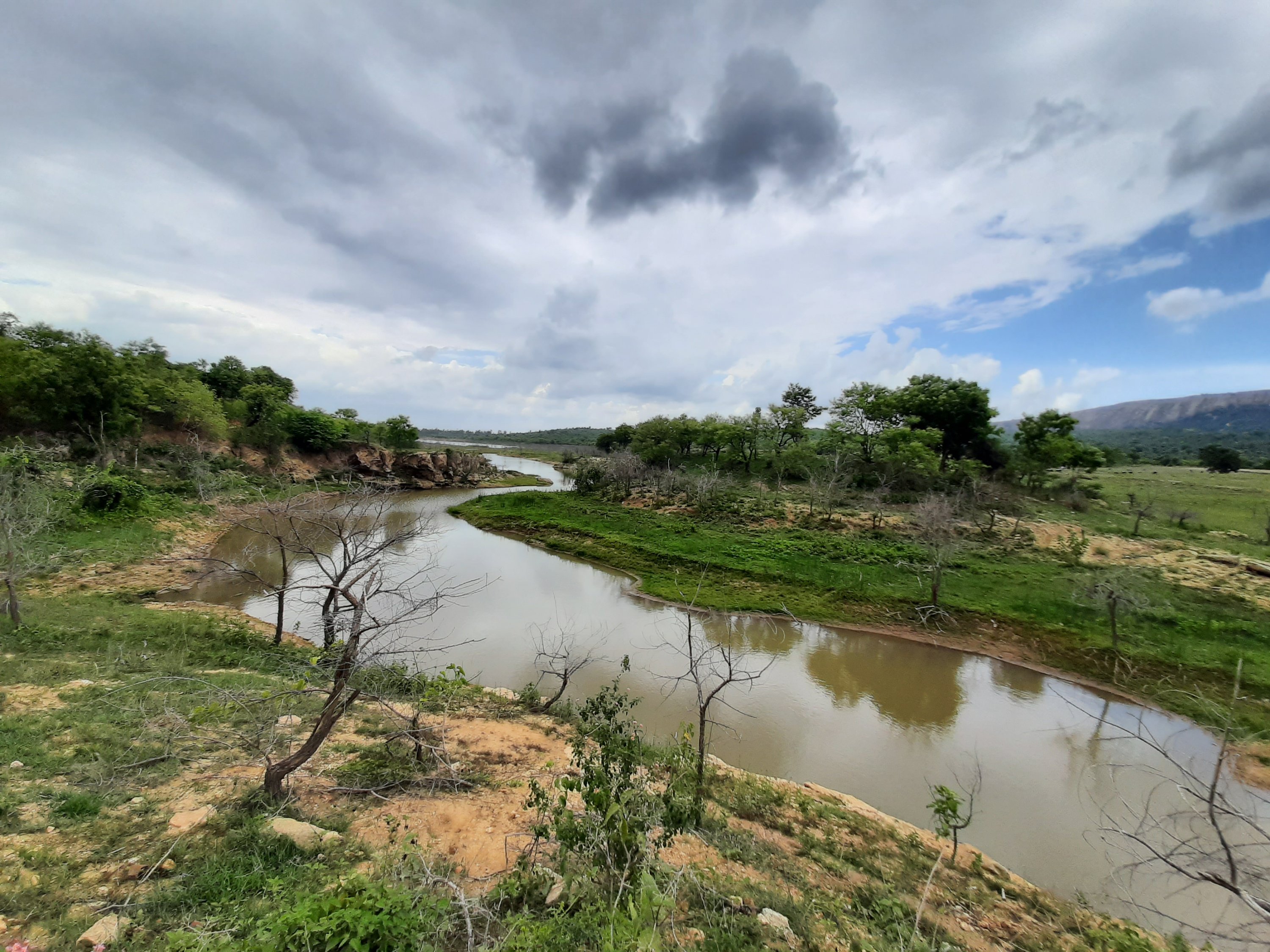
I had some biscuits and relaxed there for a bit until I felt fine. From a few known localites, we had heard that there exists a perennial pond somewhere close by. We walked behind the boulders that overlooks the millet farms beneath. We climbed up the hill further and we ventured out in pursuit of the pond. Mind you, the trek path ends at the temple and we were venturing out beyond, into the forest (Do not try this adventure). The sloppy path didn’t have a proper trail and we followed each other and stayed together so that we wouldn’t get lost. We walked further, a few broken trees (Bamboo, Indian Gooseberry, hog-plums etc.) perhaps warned us from going further, the pachyderms had just crossed the path. From there, we arrived at a small opening in the green cover- a large boulder. As the mist had engulfed the entire view, we sat there for a while hoping for it to clear out and get some good view of the valley below. But no luck and we decided to walk back.

Our stomachs were grumbling for food by the time we reached back to the base by 10.00.a.m. One of the members in our group had a relative in Kanchanahalli and hence, we were invited for brunch at their house. We drove to their house, passing through my FAVOURITE views of Karnataka: The rural hamlets of ‘Mysore Karnataka’ region. Traditional houses with wide porticos on raised platforms, red-oxide floors, clay tiled roofs supported by wooden pillars are a delight, I tell you!! Sometimes, cattle sheds on one side and a bicycle on the porch too is a common sight, so very typical to this region and so warm and old world. I have always gaped at those tiny streets in awe. So, today was my first opportunity to see the interiors of one such house, all that I had only seen in Kannada movies till date. Picture this: they are locally called ‘Thotti mane’ and the central living room has a central area which opens to the sky. Talk about natural ventilation and lighting, it has been part of our ancestral architecture from time immemorial. It also serves as an area to wash our feet and hands when we enter home, before we touch anything else. (Connect it with self-sanitizing during Covid times, after you come home from outside??)

A street at Kanchanahalli, overlooking the Bheemanakindi hill

Well, a pleasant happy day for me and a nice, happy, simple, warm meal for the tummy 😊 We head back to the city…. Hoping for another warm weekend to arrive soon….

From three directions to one destination- Ragihalli Betta

This post is of my family’s random “target destination-less” drive during the Covid unlock period. We set out in three different directions on three separate weekends but reached a place from where we got the view of the same hill, every time. By the shape of the solo hill, we would know that it was the ‘Ragihalli Betta’, located on the fringes of Bannerghatta National park. So, here are the details.

Direction 1: Kanakapura road; Destination explored: Gullahatti Kaval; View: Ragihalli Betta
The aimless drive culminated at a beautiful spot at the backwaters of the Muninagara reservoir in a village called as Gullahatti Kaval (Click here to read the detailed post). The route was mainly through millet and Banana farms dotted by small hamlets.

The road leading to Yogavana Betta, from Kanakapura road

Direction 2: Bannerghatta road; Destination explored: Koratagere Doddi; View: Ragihalli Betta
An offroading drive through Ragihalli state forest, stream crossing, forest trail and then culminating at a viewpoint- was a very welcome drive (Click here to read the detailed post).

View from Yogavana Betta

Direction 3: Mysore road; Destination explored: Yogavana Betta; View: Ragihalli Betta
After passing through small hamlets, an art school and a road with a foresty canopy leading to an ashram called as ‘Yogavana Betta’. We skipped the ashram visit and walked up the hill and climbed up a meditation hall, apparently called ‘Anubhav Mantapa’ to get a 360deg view of the surrounding. One of the views from atop was the Ragihalli Betta. Apart from a casual walk in the green neighborhood, there was nothing specific to do here. But it is a DEFINITE recommendation for those seeking a good ‘Sunset View’ point. Watch the below video of this place and the view surrounding this place.

Yogavana Betta

The little Kabini of Bangalore- Gullahatti Kaval

It has been nearly 3 months of staying at home due to the nationwide lockdown and the fear of the pandemic. With India’s unlock 1.0 in place, our family of four decided to take a short drive outside to breathe some new air. We planned to head to ‘Mango Mandi’ at a village called Somanahalli, off Kanakapura road for this weekend. As we reached there, we learnt from the locals that the government run fruit trading market has been shifted elsewhere for social distancing purposes. However, buying mangoes was just a reason for us to go out and the idea was to go “somewhere” outside home.

This reminds me of some old travel tales of my family. On weekends, my parents used to take us to Majestic bus stand from where we would board a random bus to a destination, that we had unheard of. Back then, BMTC buses plied with boards called red-board and black-board. Red-board for villages outside the city limits and Black-board for those very much within the city. We would sit in just any Red-board bus and buy a ticket to “the last stop”. Most people (Villagers travelling to and from the city) on these routes used to be familiar with the drivers and conductors. Hence, on issuing the ticket to the last stop to us, the conductor would enquire “Whose house we were visiting or where we wanted to go in the last stop”. We used to then get into a conversation with them and get details about the village we would reach at the end of our journey. We would then walk around these villages, appreciating the lung space, learning about new crops, new traditions in the countryside etc. We had thus explored “Remote” villages like Kumbalagodu (coffee plantations), Begur (the oldest Kannada inscription), Hesaraghatta (horticulture & animal husbandry farms), Gollahalli (so many varieties of Gollahallis in different directions of Bengaluru), Harohalli (so many varieties of Harohallis in different directions of Bengaluru), Haniyur (Madure Shani mahatma temple), Devanahalli (Tippu’s fort) etc. Come today, Bengaluru has grown to ‘Bruhat Bengaluru’. People would laugh at you if you called some of these places remote. Why that… even the house where we live now had once been our destination on one such Red-board bus journeys!

20200606_1236438927760731606625895.jpg
The road between Mukkodlu to Gullahatti kavalu

Back to this weekend of Unlock 1.0, we decided to continue on the road that we were driving until we reached the dead end. And that’s how we reached a village called ‘Mukkodlu’. The name of the village came as a surprise as there exists another village of the same name, back in my native district. The red soil of the farmland was being ploughed all along our route and readied for sowing Ragi millet during the monsoon. The clouds looked amazing with newly laid asphalt road. The green hills complimented the scene well, with ‘Munikallu betta’ to the right and ‘Ragi halli betta’ on the distant left. A little further from there exists the Muninagara reservoir. We thought we would stop by this place on our return.

The reservoir and beyond comes under the supervision of the forest department, a sub-division of the Bannerghatta National park. We proceeded further to know where the milestone indicated ‘1km’ – Gullahatti Kavalu. That also happened to be a ‘Dead end’ on Google maps, from where we would return. Also, the idea of our drive was to not meet any villagers or eat at any petty shops which we normally did on such trips. When we reached our destination, the end of the village was marked by a peepal tree and a government school. The ‘Arali katte’ are arenas buzzing with life and a hub of activities on a usual day in the Indian villages. This one here, was staring at us with all villagers confining themselves to their homes for social distancing. We sat there for some time, soaking in the fresh air on the fringes of Bannerghatta National park before returning.

20200606_1316215320828509429076132.jpg
The dead end point at Gullahatti kavalu

On our way back, we decided to stop at the sight of the reservoir. My itchy feet wanted to hike a bit and I dragged my folks along with me for a few meters away from the road. It was indeed a good decision. Considering we were in the fag end of summer, the reservoir still held a good amount of water. A localite who had come there to graze his cattle told us that wild animals like elephants, leopards, deer, peacocks, wild boars, porcupines etc. are spotted here in the mornings and on most other occasions. At the first sight, it seemed to me like the Kabini backwaters. Kabini is like a summer resort for all wild animals. When all water bodies within the forest run dry, this spot holds enough water and all animals come here to chill in the summers. The fact and the view of Muninagara reservoir too gave me a similar feeling. We sat there for some time until the rain gods showered blessings on us.

20200606_1352147329772729395054691.jpg
The Muninagara reservoir with Ragihalli hill in the backdrop

Thus, a day in India unlock 1.0 was well spent.

Note:
For the adventurous ones, there exists a trekking trail called ‘Muni nagara trails’ on google maps starting from the reservoir to the Ragihalli betta. But ensure that you have all permits in place before venturing on a trek here. As afore mentioned, this area belongs to the Karnataka forest department.