Tag Archives: travel

A secular pilgrimage along the Coramandel coast

This was a family backpacking trip, mainly conceptualized by my dad and had been long due. He wanted to see how the end of River Kaveri; our family deity looks like. Accordingly, we made an itinerary and a route map. Our family of four backpacked with the below itinerary:

Our Itinerary:

Day 0: Depart from Bangalore (Travel mode: Overnight train to Mayiladuthurai)
Day 1: Visit Poompuhar, Tarangambadi, Karaikal, Nagore and Velankanni (Travel mode: local bus; Stay: Church run lodges at Velankanni)
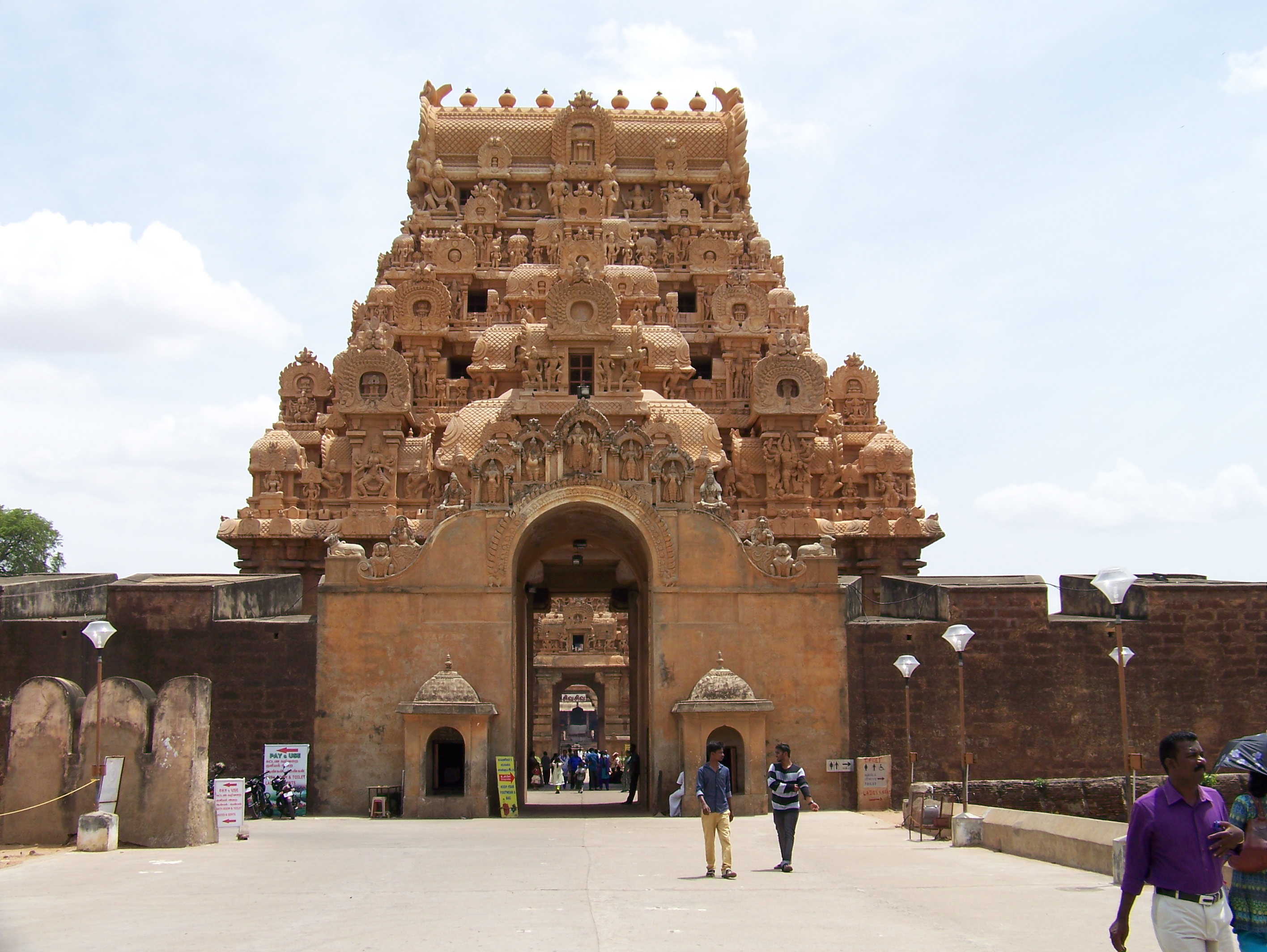
Day 2: Explore Tanjavur (Travel mode: local bus; Stay: Hotel at Trichy)
Day 3: Explore Trichy (Depart to Bangalore by overnight bus)

The first day of our backpacking is presented here, which took us across three important landmark destinations along the east-coast, covering all three prominent faiths in India. That’s why I call this part of the trip as a ‘secular trip’ with of course covering the intended destination: Poompuhar, the end of the River Kaveri or the point where this Holy river meets the sea.

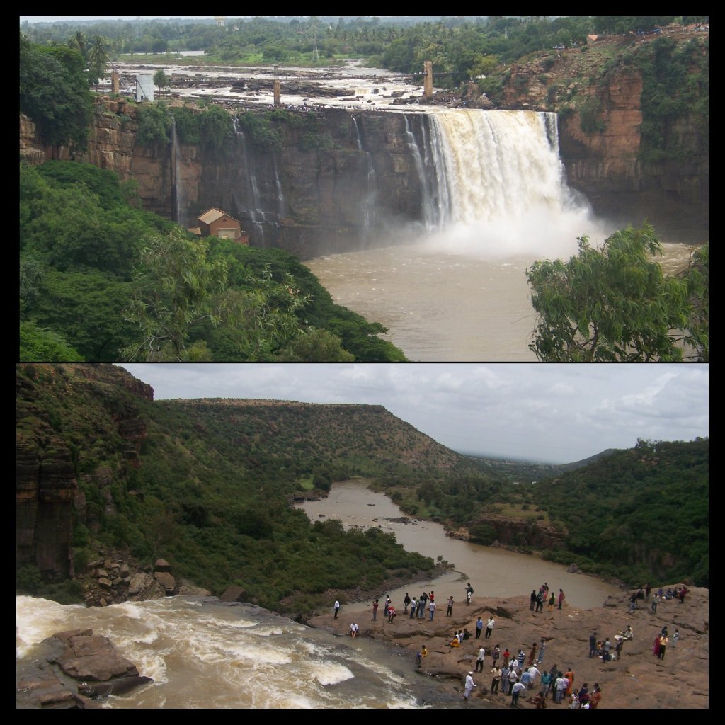
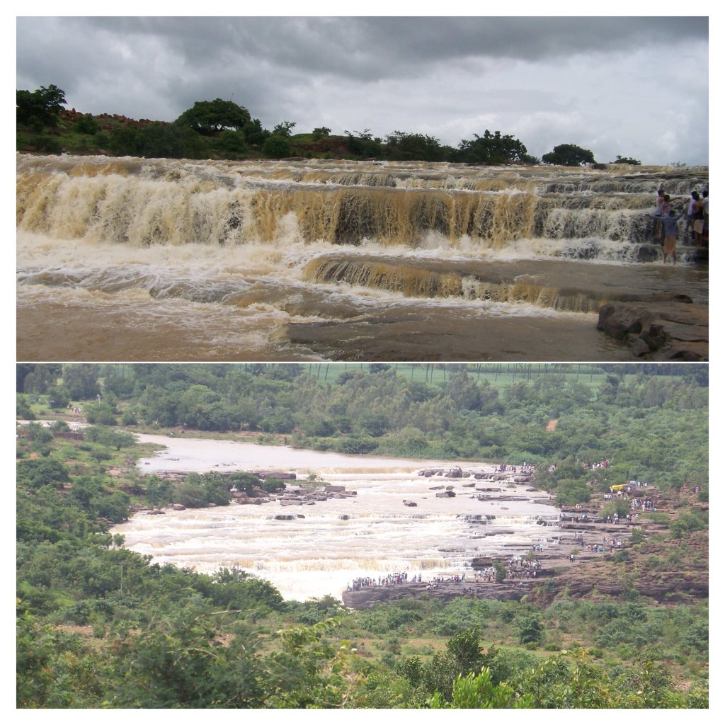
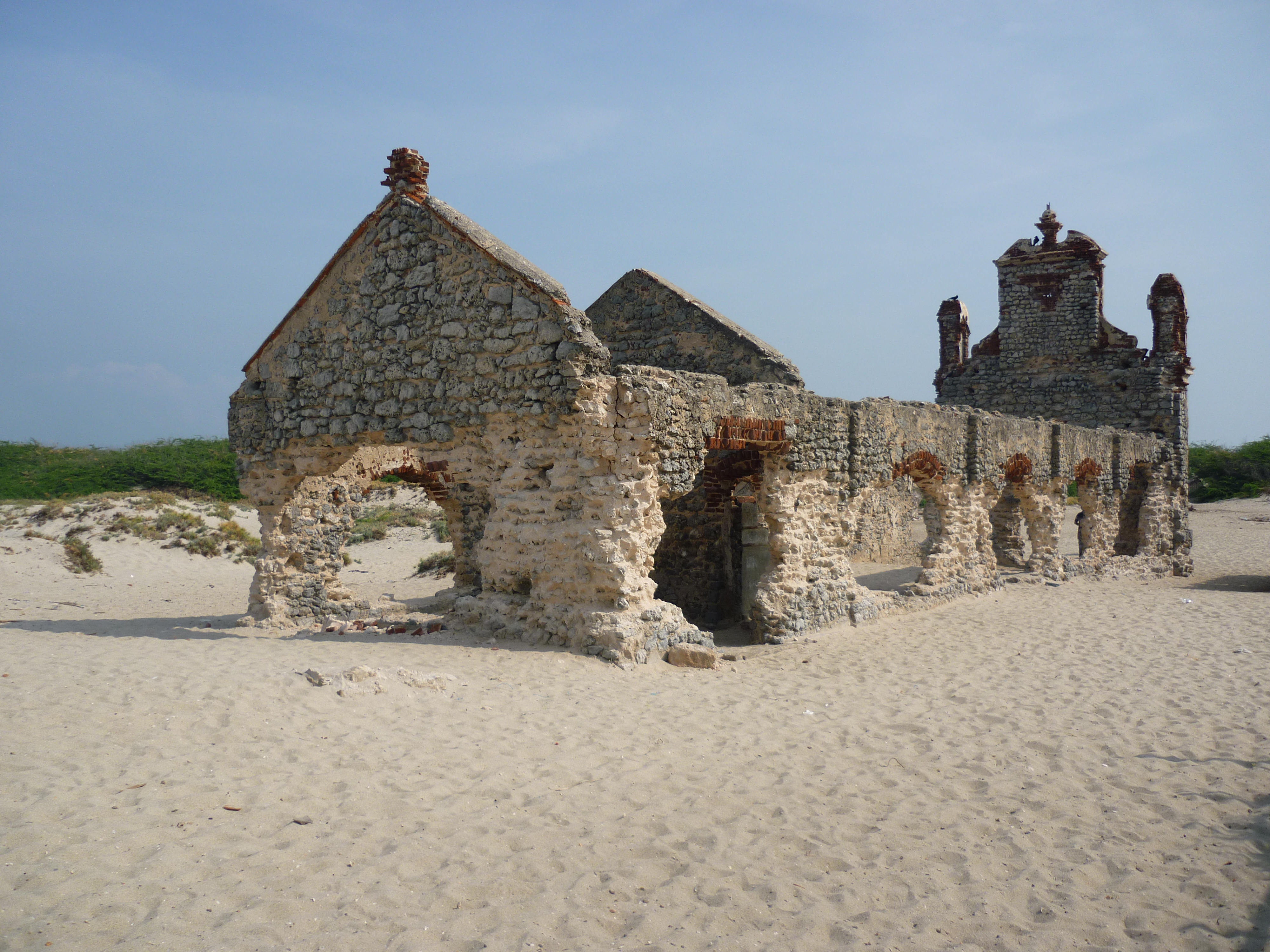
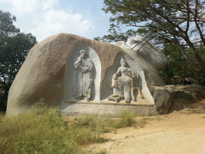
Destination 1– Poompuhar

The name reminds one of the arts and crafts of Tamil Nadu while Cauvery emporium strikes a similar bell back home at Karnataka. The link for both the names is common. While the latter relates to Tala-Cauvery, the birthplace of river Cauvery at Karnataka, the former marks the end of the same river at Tamil Nadu. Both being holy places for the Hindus of South India.

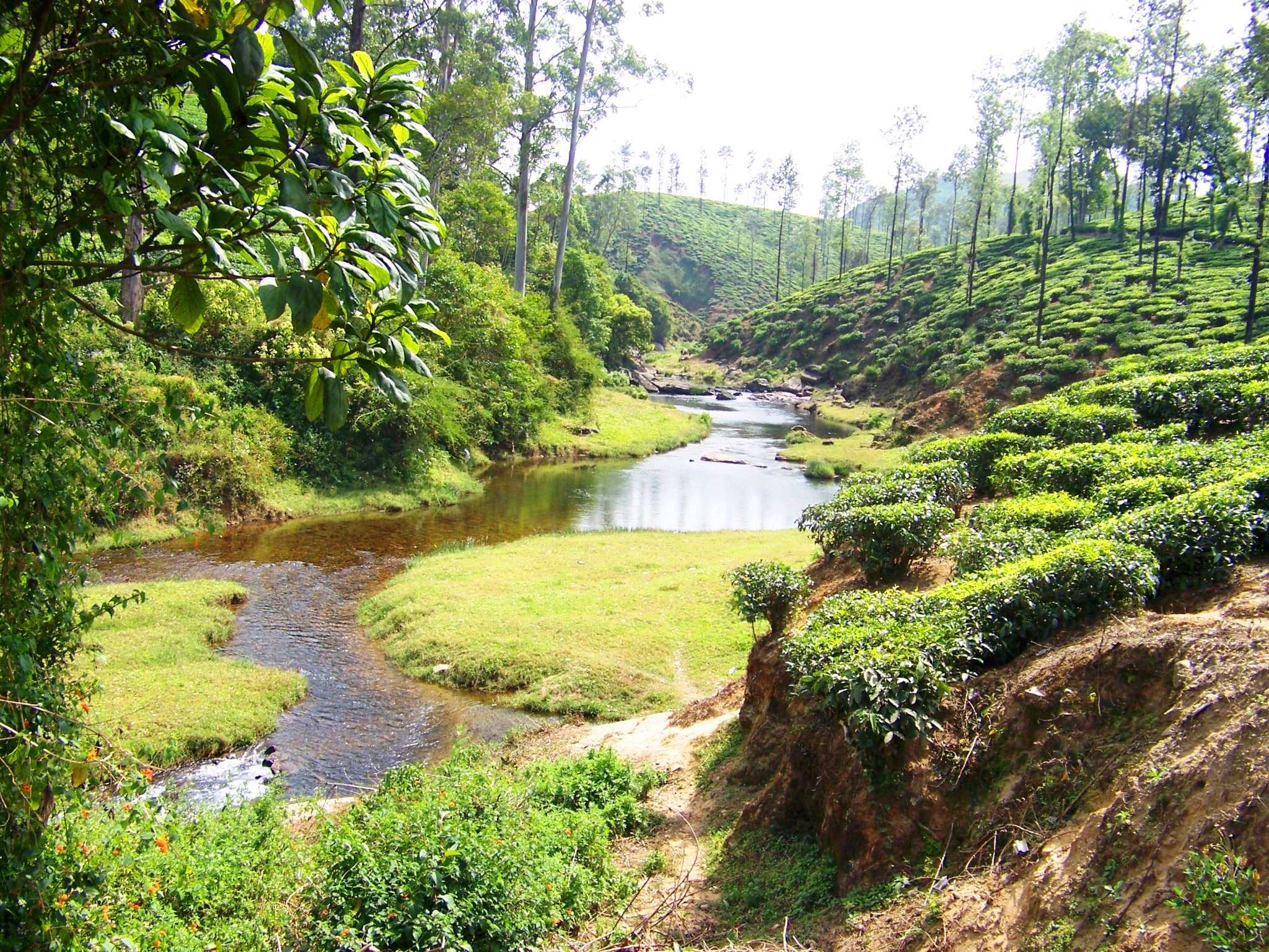
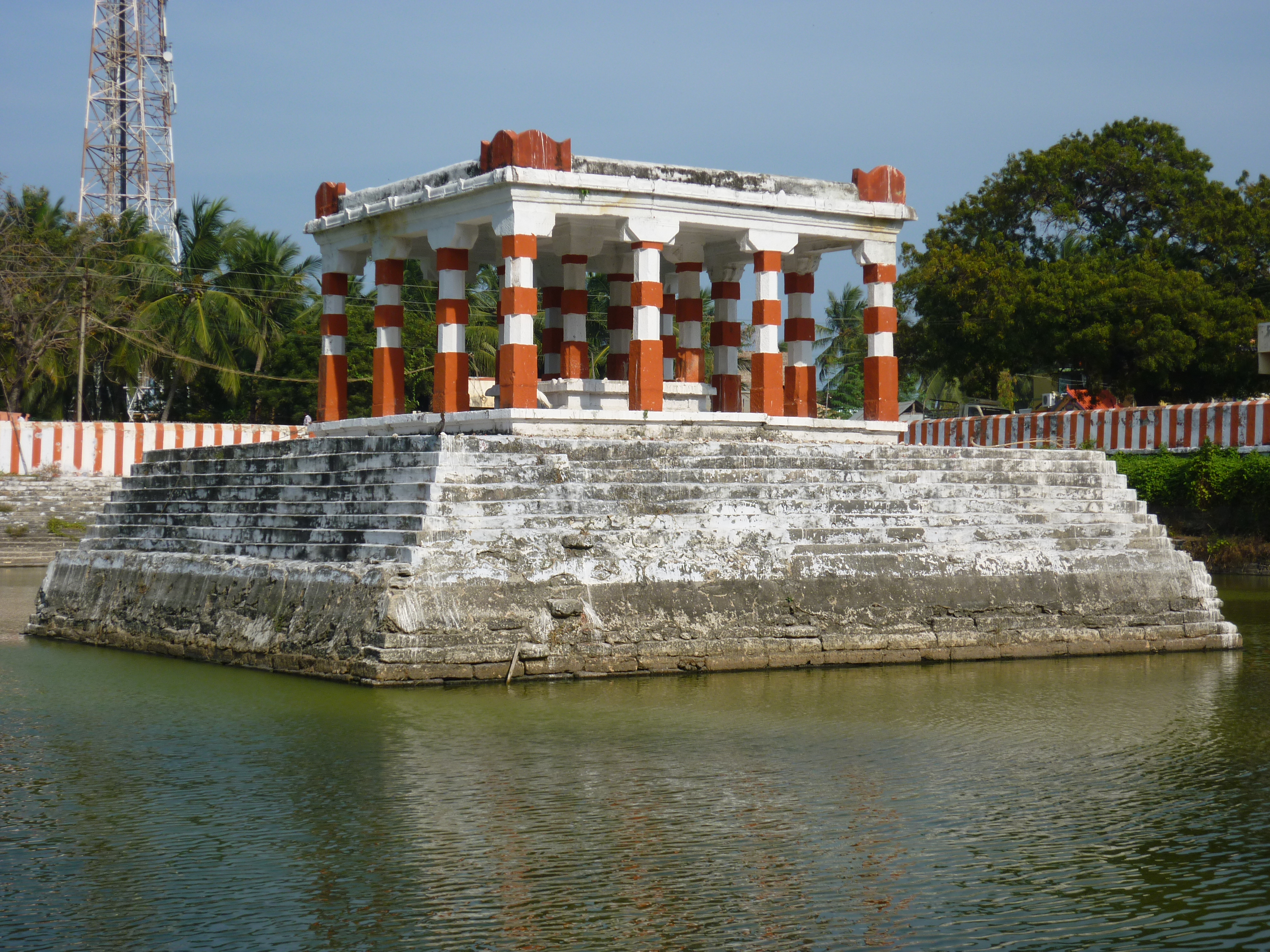
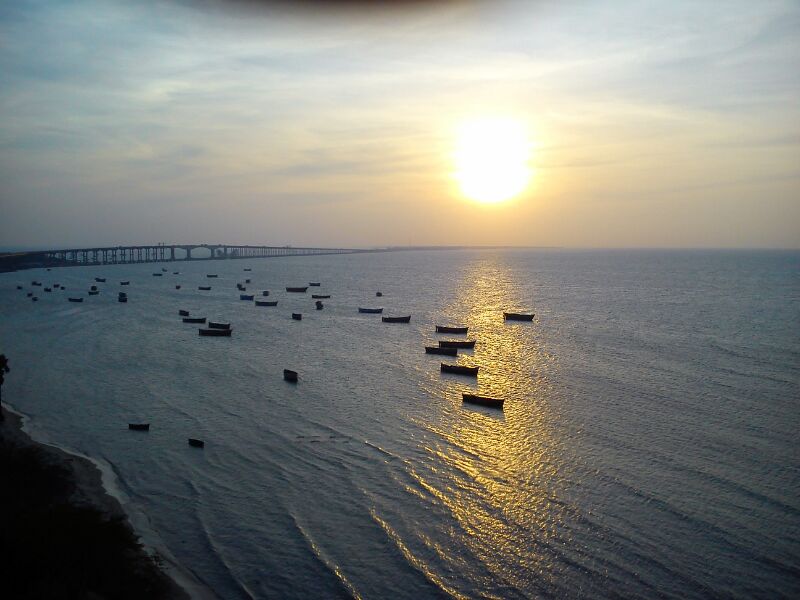
We were welcomed by a stretch of fishermen selling salted/seasoned & dried fish at the shore of this historic beach. There is a sculpture art museum on to the right side, at the entrance. To the left is Ilanji Mandran, a bathing place said to have had mysterious powers of curing health ailments that dates back to the Chola era. A walk for about a kilometer along the roaring sea leads us to the river mouth. It is believed that river Cauvery (a female) runs towards the sea (a male) at this point. If one stands and watches the river mouth at this point, the rapids of the river joining the calm sea can be seen quite evidently. The calm sea lashes her back towards the land with his waves side by side. A dip at this juncture is believed to be very holy (Hailing from a community that worships this river as a family deity, at least this is what I have grown up listening to). This place is also called Kaveripoompattinam as called by the Cholas and is a place of importance to the archaeologists.

The Ilanji Mandran at Poompuhar

Apart from the river mouth and a walk through the historical monuments mentioned above, there is nothing much to do at Poompuhar otherwise. The Kethu & Budha sthalams among the Navagraha temples are close by- I will save them for another article.

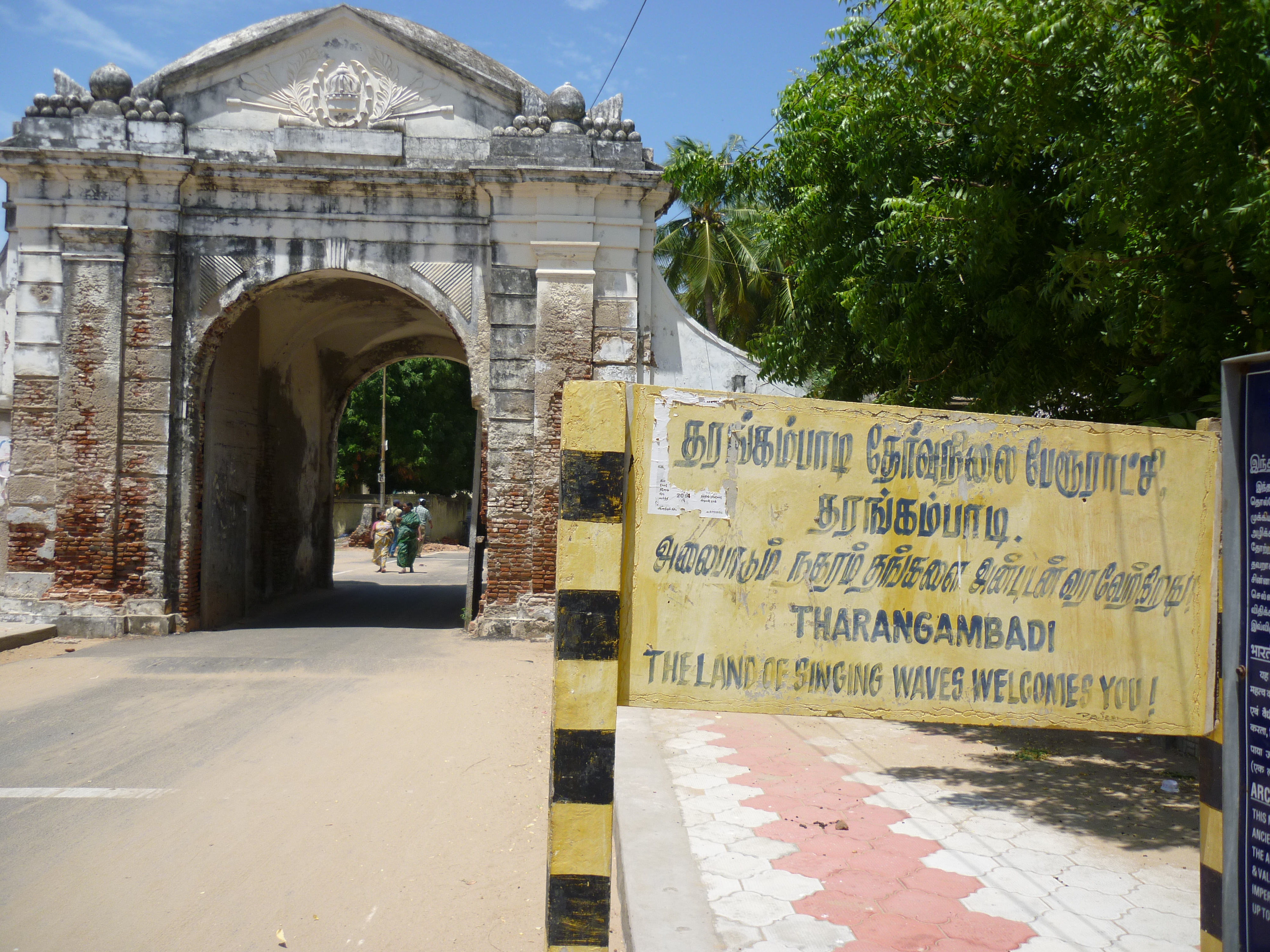
With that, we boarded a bus to our next destination- Tarangambadi. Then from there, to Karaikal beach.

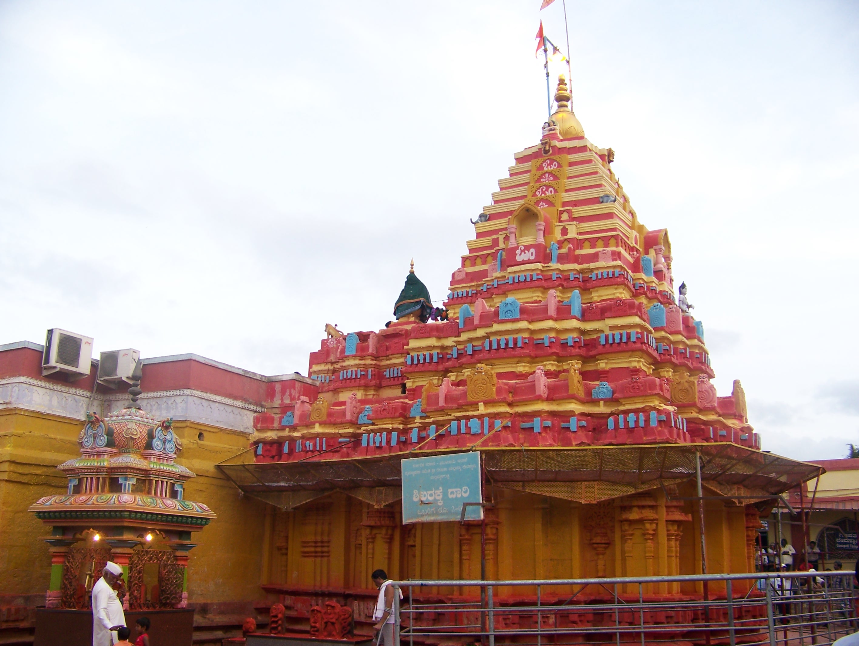
Destination 2- Nagore

The little town of Nagore is known for the Hazrat Syed Shahul Hameed Dargah of the Islam faith. We were welcomed warmly by the priests there who helped us with the procedures of offering our prayers. Going by history, this dargah stands as a symbol of peaceful co-existence between the Hindus & the Muslims as people from all faiths come here for worship. There are 5 minarets out of which the tallest one was built by a Maratha King of Tanjavur for being cured of his ailment by the miracles of Shahul Hameed. From there, we headed to our last destination of the day.

One of the 5 minarets at the Nagore dargah

Destination 3: Velankanni

It was sunset time when we arrived at the Catholic shrine of Our Lady of Good Health. We walked through the lines of stalls bustling with activities, pilgrims, tourists, hotels and other urchins to reach the seashore. This place is so crowded almost all through the year, that if one just stands in the crowd, the crowd will take you forward without you actually having to try to walk. We walked back to the Basilica of the Arogya Matha as she is fondly called to offer our prayers. The history dates back to 3 events occurring from 16th century onwards where Mother Mary appeared to a milk vendor, a buttermilk vendor and the Portuguese sailors who survived a severe sea storm. There is Matha Kulam / the holy pond and 2 chapels built at the respective places of the above occurrences.

We then took a brief walk at the donation’s library where all the gold, silver & other expensive offerings made by the devotees are kept for exhibits.

The shrine of Our Lady of Good Health at Velankanni

With that, a tiring, yet a pleasant journey in quest of god ended in a peaceful slumber at a Church run lodge… The following morning, we board another TNSRTC bus to our next destination: Tanjavur.

Offbeat Places to See in Tanjavur on a daytrip

This visit to Tanjavur was a part of our family’s backpacking trip covering the route: Bangalore – Mayiladuthurai – Poompuhar – Tarangambadi – Karaikal – Nagapattinam – Velankanni – Tanjavur – Trichy – Bangalore.

Following a long day of a secular pilgrimage in the Coromandel coast, we boarded a morning bus to Tanjavur. Tanjavur, the cradle of Dravidian culture and a hub of the Chola art and architecture needs no introduction. There’s no dearth for information on the internet. A visit to this land was on my parent’s ‘bucket list’ and this was a trip planned for its materialization. With a day’s time at our disposal (VERY short for a slow traveler like me), we decided to cover the major landmarks that a typical tourist would want to see in the capital of the Cholas.

It was the second day of our backpacking. The places covered in Tanjavur were:
• BIG temple (Brihadeesvaran temple)
• Saraswathi Mahal complex
• Grand Anicut / Kallanai dam

The details:

As in case of every other civilization, a river holds all the life. In this case, Tanjavur was born on the fertile delta created by river Kaveri. This is the land that has nurtured and held on to the Dravidian culture till date. Apart from this, its local economy has largely been agrarian based ana is rightly called as the rice bowl of South India.

Landmark 1: The Big temple

The iconic monolith of this land was spotted even as our bus was still pulling off at the bus station. The monolith seated gracefully atop the ancient temple with a weight of 800 tonnes was still far away. As we reached, we stood there in awe, gazing at the vast premises of the mighty temple. The temple tower is the tallest in the world and stands testimony to the Cholas’ love for art and fine engineering skills even in the iron age. It is believed that a ramp was laid from about six kilometers to facilitate the placement of the monolith Kalasha atop the tower. The walls of the corridor are adorned by fine paintings that were done with a mixture of limestone and organic extracts. The temple walls have sculptures of numerous mythic animals which is the highlight of the Cholas’ temple architecture.

The entrance at the Brihadeesvaran temple

‘The Great living Chola temples’ is a group of three Chola temples located across Tanjavur district. Together, these three temples represent an architectural conception of the pure form of the Dravidian style. The Tanjavur Brihadeshwara temple is the most easily accessible of them all and is located in the heart of the city. (The other two temples are the Airavatesvara temple at Darasuram and Gangaikondacholisvaram). Although the Brihadeshwara temple is fondly called as the Big temple, it has multiple names. With a simple translation of the name into local language, it is called Thanjavur Periya kovil. The great Chola king Raja raja named this temple as Rajarajesvaram and the deity Shiva in Linga form as Peruvudaiyar. A few people also refer the temple with the name of its deity as Peruvudaiyar kovil.

The Tanjavur paintings adorning one of the roofs

Landmark 2: Saraswathi Mahal complex

We took an autorickshaw ride from the Big temple to Saraswathi Mahal. This is reckoned among the oldest functional libraries in the world and was patronized by the Tanjavur rulers. One can find some very old, rare and original copies of important manuscripts, scientific research publications etc. here. Adjoining it, is the palace of the Marathas of Tanjavur. The palace is partially used as the residence of the descendants and remaining portion is converted into a museum.

Behind this building, is the art museum which houses some rare and famous bronze idols created during the Chola era. The Cholas were the earliest people to have used the lost wax technique to create the bronze idols with a very scientific approach (as per the documented procedures in the Vedas).

The Saraswathi Mahal Library

Just outside the museum, we picked up a pair of Tanjavur bommai from the souvenir shop. These famous Tanjavur dolls are colorful handcrafted figurines where the head is suspended on a pivot which gives a dancing/swinging movement to the doll. Hence, they are often referred as the Tanjavur thalayatti bommai or the dancing headed dolls. Another artform you cannot ignore or miss while in this city are the Tanjavur paintings. Considered as a divine artform, with gold embellishments, Tanjavur paintings are considered as a symbol of royalty.

Landmark 3: Grand Anicut / Kallanai dam

From there, we boarded a local bus to reach Grand Anicut (as called by the Britishers) or Kallanai (the local name). This is a standing example of the engineering marvels constructed over 2000 years ago by the Cholas (later modified by the British). This oldest functional water regulation structure in the world is a dam constructed with uneven stones / random boulders across river Kaveri with a desperate intention to divert the water before joining the sea so that it can be used for irrigation around the delta region. This dam divides the river into four streams known as Kollidam Aru, Kaveri, Vennar and Puthu. Later, the Lower Anicut/ Kollidam was constructed by the British before the water actually joins the sea.

An epitaph at the  Grand Anicut
An epitaph at the Grand Anicut

With this, our time in Tanjavur had almost come to an end. On the other end of the dame, we sat inside a local bus and waited for it to start to our next destination on our trip: Trichy.

Visiting the Niagara of Karnataka- Gokak

This is a pick from old memories of exactly a year ago, in August 2013. My mother was away in Belagavi for a month-long business trip and I had decided to catch up with her over the weekend. We then got together, and explored the places around Belgaum, fondly called Belagavi. This time, it was only a day trip around Belgaum with a quick visit to the widest waterfall in my state, the Niagara of Karnataka.

Our Itinerary:
Friday: Overnight journey from Bangalore to Belgaum
Saturday: Explore Gokak (waterfalls, hanging bridge & Tarakeshwara temple), Godchinmalki waterfalls, Savadatti Yellamma temple)- Return to Bangalore by night journey.

The Details:

I boarded the bus to Belgaum from Bangalore and my mom was there to receive me when I alighted there the next morning… We freshened up at the place where mom was put up and then headed straight to Gokak. The little town known for its cotton mill, is also famous for the nature’s treat- the mighty Niagara of Karnataka. The bubbling, roaring and crashing waters of the Ghataprabha river creates steady patterns here with endless rhythm while it leaps down from 52meters between two tall, craggy cliffs to form the Gokak falls.

The century old hanging bridge, the only mode for the textile workers to cross the river allows the public to enjoy the breathtaking vista of the waterfall as the gushing water plummets down. The presence of turbines dating back to 1885 stands testimony to the electricity generation station established here which still provides power source for the cotton mill across the street. The 11th century Shiva temple dedicated to Lord Mahalingeshwara (Locally known as Tarakeshwara temple), built in the Kalyani Chalukyan style, faces the cotton mill and flanks one side of the gorge.

Above: The front view of Gokak falls from the Volkart view point; Below: A view from the Hanging bridge.

Meanwhile, I called a friend of mine who hails from Belagavi district to enquire about other places that we could visit around his hometown. He guided us to a small village named Godchinmalki where river Markandeya cascades down amid a scenic backdrop forming another beautiful waterfall called by the same name. Mom and I walked down for 2kms through rolling green pastures, fields of maize and banana plantation to reach this waterfall that plummets down in 2 tiers. Once we reached the place, it was a thorough treat to our senses to watch the waterfalls racing ferociously through the deep gorge.

On our way back, we took a little longer route from where we got a complete view of river Markandeya snaking through the greens. A 9kms long underground canal carries water from the river across which can be seen emerging out of the hill from this viewpoint. The snaking roads with beautiful views of the valley was a wonderful drive to the city.

Top: The Godchinmalki waterfalls; Below: The Gochinmalki view point from the main road

After all the waterfall hopping was done, it was time for some temple visit. We headed to Saundatti a.k.a. Savadatti. This place was the capital of the Ratta / Rastrakuta dynasty from 820, until it was shifted to Belgaum in 1230. There is a fort here also called the Parasgad fort. But the most famous is the Renukadevi temple located atop the Yellamma gudda. This is an important place for devout followers of Goddess Shakthi and also for the devadasis- or the servants of god. We had a good darshan during the evening pooja time.

Savadatti Yellamma temple

With that, it was a quick wrap for a short weekend and time for me to head back to Bangalore for another long and boring work week ahead…

Must eat while at Belagavi/ Belgaum:

  • Karadantu at Gokak– it is a sweet made with dry fruits rolled into balls with jaggery.
  • Kunda at Belgaum– This is a sweet made with milk.

The land of the singing waves – Tranquebar

This visit to Tarangambadi was a part of our family’s backpacking trip, mainly conceptualized to cover a portion of the Coromandel coast. Our itinerary for this trip was Bangalore – Mayiladuthurai – Poompuhar – Tarangambadi – Karaikal – Nagapattinam – Velankanni – Tanjavur – Trichy – Bangalore.

This post is about destination no.3 on the first day on the east coast road. I had read about this place in one of the history texts about the Colonial empire in India. I had visited Portuguese, British and the French settlement towns during my earlier travels. The Danish colonized in India for over 200 years with three important settlements. Serampore (in West Bengal), Tranquebar (in Tamil Nadu) and Nicobar Islands (in Andaman & Nicobar Islands, all along the Bay of Bengal. To read about the existence of these places in modern day’s context, there was barely any information available online from a traveler’s perspective. Since we were anyway doing the ECR tour, my curiosity to know more about a Danish settlement motivated me to add Tranquebar in our itinerary. ‘Tranquebar’ as the Scandinavians called it, is a humble town known as ‘Tarangambadi’ in present times.

As we continued our secular pilgrimage, I bought tickets to a destination that was unheard of to my family until that moment. I requested the conductor to inform me when we arrived there. Accordingly, we alighted the bus at a small junction. The place looked very laid back, simple, untouched by any major developmental investments, just like any other fishing hamlet on the coasts of India. The bus conductor pointed to a small road to the right and guided us telling “one kilometer ahead is the fort”, and blew the whistle indicating the driver to proceed. My parents looked at me with a blank look on their face. I could sense that ‘Where are you taking us on this hot afternoon?’ question in their eyes. Although with the first look of the place, I too had similar apprehensions running in my mind, I wanted to walk further to see what was really there!

We walked for about half a kilometer and an old arch done with Danish art welcomed us at the entrance of the town. A board by the side of the arch read: ‘Welcome to- The land of the singing waves- Tranquebar’.

The entrance arch
The arch at the entrance of Tarangambadi/Tranquebar

As we walked through this town welcome gate, the feel of the place transcended us instantly to a different country, or a different era- perhaps. The roads were super empty & clean and old Danish buildings stood tall on either side of it. The Zion church, the Teresa’s convent school, the Danish governor’s bungalow among several other structures that tell tales of an era bygone finally led us to a fort. ‘Fort Dansborg’ as it is called, is a structure peacefully nestled on the calm shores facing the Bay of Bengal. The moment we got a glimpse of the beach from the fort entrance, we got the link to the name of this quaint little place- Tranquebar: the land of tranquil waters. The place had tranquility overloaded not just in its waters, but in its air, land and whatever we saw around. I’m usually not a beach person, but this place was magical!

Since there are just countable properties (heritage bungalows turned resorts) in the town, Tranquebar is still unconquered on the tourist radar. Also, the unavailability of affordable food in a long stretch of kilometers, the budget hoppers are those who just drop in for day trips. Hence, except for a handful of fishermen, evenings and early mornings are idyllic with you being your only company if you choose to take stroll along the calm beach. This is by far, one of the BEST beaches along the east coast that I have been to.

The serene shoreline at Tranquebar
The serene shoreline around the Tranquebar fort

The fort is well maintained and converted into a museum. An important port between 1600s to early 1900s, the walls of the port now lay dilapidated, majorly battered by the tsunami in the year 2004. A stroll along the beach take you to the Masilamaninathar temple. It dates back to 13.C.E. and is believed to have mythological importance. The sculptures on the walls of this temple and the shikara have been corroded by the salts.

Although there isn’t much to see around in Tranquebar, it was a place that filled our mind with peace and tranquility even with just a few hours spent there. My parents too, were equally excited about the place where I had brought them to. I must admit that Tarangambadi is a place that I would COME BACK soon. Then, with more time and a hotel reservation at one of those bungalows on its beaches. But for now, it was a hard but a helpless option for us to pull ourselves out of this place. Unsatisfied with the quick visit, we promised ourselves to come back exclusively to stay here as we left for our next destination- Nagore.

Mission accomplished- Kumara Parvatha

This trek was planned to celebrate the 1st anniversary of Sam’s farewell trek (Click here for details).. on the same day, exactly a year ago..

Let me get you going directly from where this trek to Kumara parvatha or KP peak is actually supposed to start. We reached Kukke Sri kshetra and checked into the lodge(a meagre 100Rs. Per day) run by the temple trust, freshened up and feasted on some sumptuous Mangalorean food for breakfast. Without wasting much time, we started the much hyped- one of the toughest treks in South India.. to the Kumara parvatha peak in the Pushpagiri wildlife zone.

The original plan was to start from the base by 7.00.a.m and camp at Bhatru mane. Then, leave Bhatru mane by 3.00.a.m the next morning and reach the peak to witness the sunrise, what is supposedly one of the best.

As planned, we entered the trekking trail.. It starts off with thick forest around and steep climbs uphill.. There was NO water sources along the way (We didn’t know that there was a perennial stream, with a small deviation after 2.5km) and a possibility of occasional encounters with elephants. We took frequent stops before taking a longer halt at Bhima’s rock. This stretch of 3km had oozed the fluid out of us..

 A view from Bhima's rock
A view from Bhima’s rock

Once this 3kms stretch was covered, we got our first view of Kukke town.. The thick canopy of forests made way to the grasslands after walking 1km further from there.. It was well past noon and the sun shined at its hottest.. We were running out of water already.. We started to wonder if Bhatru mane really existed and literally pulled ourselves to reach there. Or rather say, we pushed ourselves to walk the small distance that seemed never ending.. Finally… we were overjoyed at the first glimpse of Bhatru mane…

The first glance of Bhatru mane

We ran down to his nestle amid a small piece of green land.. I find NO words to express the joy of finding water.. That too, clear and cold water from the stream that ran through his farm.. We had a simple, yet the tastiest lunch served by Bhatru and rested under the shades of his arecanut farm..

We then made a small change in the plan and decided to continue the trek until it was dark. We feared the pace at which we were climbing up and did not want to return late on the following day.. We halted at a view point along the way for some photographs, before reaching the forest checkpost. We continued our hike up after registering our names at the forest office.. We stopped again at yet another view point.. The sun was coming down by the time we reached kal-mantapa and hence we decided to pitch our tent near the stream that ran by..

The sunset from our tent

The sunset from our tent

I don’t remember which sane person in the group chose the place.. I agree that we got a place which became every other trekker’s envy.. The place was for sure, a top rated spot for sunset viewing.. But we girls, who stayed inside the tent know what we went through that night.. The tent was pitched on a slope, on the edge of a rocky cliff which seemed like the place where the earth ended.. It was soon dark and we ate the little food that we had carried and hit the bed (Read hit the rocks)..

The boys comforted themselves in their sleeping bags and threw the poor girls inside the tent.. The entire night went by like this: ‘Our respective backpacks were used as pillows inside our tent. We all would slide down with our bags inside the tent.. again we would push back everything and move up.. Slide down.. Slide up.. Phew..!!’ And a while into midnight.. The intensity of the wind also increased.. The cover of the tent started to fly.. We hoped for it to be 3.00.a.m soon so that we all could start our ascend.. But another surprise was awaiting us.. Madhu heard the cracking sound of the tent support and scared all the girls inside to vacate the tent. We carried our luggage from inside and jumped out of the tent, one by one.. The last girl just came out and the tent crashed down to a flat.. The guys woke up and one of them attempted to slowly remove the pegs.. One peg was removed and then… The tent flew.. away from our reach.. off the cliff.. down the valley.. We had borrowed the tent, on hire.

Everyone woke up and sat wondering why this had to happen. It was still dark at 4.00.a.m. and with the wind that continued to blow ruthlessly, our ascend to the peak seemed impossible.. We stayed back until sunrise 😦 We decided to compromise on one of the main agenda of our trek- Watching the sunrise at KP peak.

After there was dawn,one of the boys dared to go down the cliff. He had a thrilling feat with adventure and managed to bring back the tent that had settled on a boulder in the middle of a water body, down below in the valley.. More than getting excited about finding the tent, we were all celebrating his safe return.. It was around 7.00.a.m by the time we started our ascent.

Inspite of missing the sunrise, the views post that period were equally spectacular, all along the way. The climb was pretty smooth. It was around 11.00.a.m. by the time we reached the first peak/ false peak- Shesha parvatha.

Post sunrise

The view from the base of Shesha Parvatha

After just a few photo moments, we decided to continue our journey.. We descended the steep rock and waded through super cool, thick jungles.. And then, climbed up another steep rock. This rockclimbing with bare hands and legs reminded me of our monkey ancestors.!! A small walk further up took us to the actual end of the earth. Right there, we had conquered our destination- Kumara Parvatha..!!

Shiva temple atop Pushpagiri hill

Shiva temple atop Kumara parvatha

Thanking the diety with a small bow in the temple on the peak, we set our return journey.. Getting down the rocky slope of KP seemed tricky with one of my friends ending up with torn trousers when he decided to sit and slide down on his butt 😉

The descend from Shesha Psrvatha was no easy task either. The loose gravel all along the trail made walking difficult without slipping. It was 4.00.p.m by the time we reached Bhatru mane.. We realised that we had covered only half the distance and had very less time left with sunlight.. We had to complete the remaining distance before it got dark because that was the toughest stretch with thick forests and wild animals. We had a quick lunch at Bhatru mane and got some rest in fast forward mode and started our descend by 5.00.p.m..

We knew we had very less time in hand and a LONG way to go.. We all walked as fast as we could. Our legs had given up already.. I was preparing my mind to stay back in the forest and make a feast of myself to some wild animal at night.. I ran down the slope at times.. My knees seemed like they would part away from my thighs.. We saw the sun coming down.. We continued to walk fast.. We saw the sun going down the horizon.. We paced up.. Suddenly we all halted.. There was pin drop silence.. We realised that some wild animal(mostly elephant) was somewhere around.. It took us a few minutes to feel the sound move away from us.. Then, we resumed our walk. We saw the bright day fade into darkness and every shade in this process. The toughest and the last stretch was almost coming to an end.. We had FINALLY reached the KP gate… And the last ray of light too waned into darkness.. Thus came an end to the KP trek- a mission….. accomplished..!!

We all then freshened up at the same lodge and did a quick visit to the Kukke temple before hitting the roads on our return journey.

NOTE: The above story is written based on my trek back in 2013 when there was no restriction on camping in the entire trail. As on 2019, camping is allowed only around the forest checkpost and Bhatru mane. So, it is wiser to plan the distance, hiking time and camping accordingly.

Must do things/ Highlights of Kumara parvatha trek:

  • Bhatru mane is the ONLY place you will find food and it is an experience in itself to get your turn in the queue to have your meal served. The same basic rice and sambar is served for all 3 meals and nobody complains. Not tasty, but finding food after a long day is LUXURY here. Bhatru has a fixed time for serving food and very punctual. The crowd is huge especially on weekends and the wait for your meal can take longer if you dont have your own plate.
  • The sunset from the view point enroute forest checkpost or Kal-Mantapa
  • To watch the Sunrise from Kumara parvatha is like going to a different world. Try to make it there in time.
  • The sky is in its clearest form and star gazing at night is a whole different experience. You see so many stars, bright and clear that it feels as if the sky has moved closer to earth. We got lucky as it was also a night of a meteor shower, so we saw many shooting stars.
  • Drinking water from the stream felt like nectar. So clean and tasty. You can fill your bottles at 4 places along the way. First after 3kms, near the Bhimas rock. Second, at Bhatru mane. Third, at the forest checkpost. Fourth, at a stream just before kal-mantapa.

Of pre-monsoon showers and coffee blossoms

It is that time of the year when the entire hill station awakens with the fragrance of the blossoms.. On the ninth day after the 1st pre-monsoon showers, the coffee plants around the hills of Kodagu will be in bloom..

P1000890

It is an annual spectacle of nature whose occurance is unpredictable and is wholely dependent on the pre-monsoon showers. If the rain fails, it creates some sort of panic among the growers who then resort to artificial sprinkling sytems.. Be it rain showers or irrigation, in either case, what follows is something that one must experience atleast once in a lifetime..

White bunches of coffee blossoms adorn the trees as if some one has strewn cotton all over the hills.. And these flowers last for a maximum of 24 hrs which makes it even more special.. And like the saying goes.. You HAVE to be at the right place at the right TIME to see the right thing happen..

Have you experienced the fragrance of coffee flowers?

Explore the Best of Valparai on a Weekend

My friends and I had heard sufficiently about the rich wildlife of the region surrounding Pollachi, its beautiful sceneries and perfectly trimmed tea estates. Valparai is a lesser known hill station in the Indira Gandhi Wildlife Sanctuary (earlier known as Annamalai Wildlife Sanctuary). Kollywood stars and burnt out urbanites frequent this place to de-stress themselves and savor a slice of nature. Here, as one ambles past mud walled, thatched roof dwellings, granaries of farmers and tea estates fringed plateau, don’t be surprised if you happen to hear someone screaming ‘start camera’, ‘action’. This is a hot spot for movie makers with over 1500 movies and commercials having been shot here. And we too got lucky when we happened to visit the sets and share our homestay with the crew of the movie- ‘Madras cafe’ during this trip of ours.

A weekend itinerary was primarily planned by one of my friends and a few must-see items were pushed into the plan by me. Since this place falls on the border of Kerala and Tamil Nadu, we decided to make it a three states’ drive including Karnataka. Accordingly, five of us started from Bangalore on a Friday night. Since it is also a bio-diversity hotspot, I had listed 5 animals on my ‘to-spot’ list while at Valparai. Valparai is the end destination after driving through 32 hairpin bends. Being a hill station, Valparai weather is specifically delightful with a cool climate throughout the year. It is usually the road leading to Valparai that is enjoyable with scenic vistas and photo-points. I had enlisted them with day 1 in the Tamil Nadu side of the sanctuary and then spending the second day on the Kerala side of the forested land.

Itinerary:

Day 0: Leave from Bangalore by night (Own car)
Day 1: Reach Pollachi before sunrise. Backwaters of the Aliyar dam, monkey falls, Loam’s viewpoint, Carver Marsh viewpoint, Congreve falls, Vinayagar temple, Birla falls, Balaji temple, Iraichalparai falls, Nallamudi Pooncholai viewpoint, ChinnarKallar hanging bridge trek, Sholaiyar backwaters (night stay at a homestay in Chalakudy)
Day 2: Athirapally falls, Vazachal falls and return to Bengaluru via Ooty.

The details:

Part 1: Tamil Nadu

During the night journey, I had dozed away on the rear seat of the car. When I opened my eyes to the misty morning dawn, our car was greeted by beautiful countryside with tree-lined roads, emerald fields of paddy, whispering palms and coconut plantations in the backdrop of the towering Western Ghats. We had reached Pollachi in Tamil Nadu. We waited near Aliyar park until 06.00.a.m. for the forest check post to open.

a. We registered our entry into the wildlife sanctuary there and proceeded on our journey. Our drive further towards Valparai, was an ascent along the winding road by the backwaters of the Aliyar irrigation dam.

View of the Aliyar backwaters

b. Four kilometers further from the forest check post, we reached the monkey falls. The waterfall is aptly named due to the many troublesome monkeys here. One even entered our car and happily carried away a bag full of fruits from the rear seat. Our drive continued…

c. Just as we approached the 9th curve (the Loam’s viewpoint), we were greeted by this gentleman who was calmly grazing on the edge of the steep rocks.
We scored off the first member on our list of top 5 wildlife to see- ‘The Nilgiri Tahr’.

Nilgiri Tahr – Photo credits: Samson Joseph

d. Continuing our drive, we stopped at Carver Marsh viewpoint adjoining the Kavarkal estate. On a clear day, we were told that one can see the Sholayar reservoir (2nd deepest dam in Asia) from there.

e. We then cruised past the Tiger valley from where we caught a good view of the upper Aliyar reservoir.

At the entrance to Sholayar / Kallyar estates

f. We covered Congreve falls (located in the Nadumalai estate), Vinayagar temple (Jayashree estate) & Birla falls along the way up. We got good view of the Manopally forest and the grass hills of the sanctuary.

g. Ox-bow lakes situated inside the protected area is supposedly the highlight of this region for those who can manage to get permission from the forest authorities. We failed at it since we didn’t have insufficient information on the channels for the permits.

h. We visited the Balaji temple and the nearby Iraichalparai falls along way.

Just along our way, it was time to score off no.2: groups of ‘Lion tailed Macaque’ were walking all over the road and around. Even before we realized, we had reached the hilltop.

Lion Tailed Macaque- Valparai

i. We stopped by and trekked through the tea estates to reach the ‘Seen god shrine’ at the Nallamudi Pooncholai viewpoint. An old man, who claims to have seen god, blessed us with some prayers and turned out to be an encyclopedia of knowledge about the local culture and history. He explained to us about the various tribal settlements in these hills… pointing out at colonies, he would tell- Kadars, Muthuvars and Malai Malasars. They are estimated to have 190 households in 8 settlements in the sanctuary.

While we walked towards our car, the women picking tea shoots warned us not to proceed further. She pointed at a herd of 8-9 elephants feasting around at a distance, thus scoring off no.3 on my list.

j. We then drove to ChinnarKallar for the hanging bridge trek. In spite of driving all the way, we refrained from shelling out 250 Rs. per head just for the entry which sounded to us more like a bribe at the forest check post. This place is among the highest rainfall receiving areas in India. No doubt that the Valparai weather is pleasant all through the year and is an upcoming weekend destination among the urban crowd of the nearby metro cities.

We put our car in reverse and just then… no.4: The giant flying squirrel (a young one and wasn’t flying though) crossed our road. We were excited…!!

k. After covering places in the Tamil Nadu part of the sanctuary, we headed towards the Kerala border. We saw a calm stretch of the Koolangal river and decided to spend some time there. We could not compel ourselves from not taking a sip of its crystal-clear waters.

And right there. we saw this little creature on no.5: ‘The common map butterfly

The Common map butterfly

Part 2: Kerala

We registered at the border check post and prepared to enter the Kerala land. Thick rainforests on both sides accompanied us all the way till our destination. We happened to drive through what I think is one of the dangerous roads I have been through. With the Sholaiyar backwaters on one side and a valley on the other side, only one vehicle can pass at a time. Beautiful views for most of the stretch kept us in an awe. Tunnels have been bored through the mountains to supply water to Parambikulam reserve from the Nirar dam.

We reached Athirapally reserve just after sunset. We got a quick glance of the beautiful waters cascading down to join the Chalakudy river. It was soon dark, and we checked into Maria cottage (a local homestay) where we were made us feel at home and served some sumptuous Mallu food.

Next morning, we walked past the palm plantations to reach the Chalakudy river to freshen up. This place is frequented by elephants at all times, but we did not care. We enjoyed the clear but rapids of the water there. We took a refreshing dip before returning to our homestay. We checked out of the place after having a good filling Malayalee breakfast.

Post this, we went back to the Athirapally waterfalls. We walked down to the base of the waterfalls and spent good time there. We had to then continue our drive, as our target was to reach Bangalore by night. After a quick stop at the Vazachal waterfalls (it is more like water flowing down a steep rock than a waterfall), we decided to say goodbye to Kerala.

Athirapally waterfalls

Part 3: Karnataka

The original plan was to drive through the route covering Ooty-Bandipur-Mysore to reach Bangalore. But, since we were behind schedule, we could not reach Bandipur before the forest gates closed (the forest gates are open only between 06.00a.m. to 06.p.m.). So, we decided to drive back through the curvy stretch of Pollachi road again.

We further drove through Udumalpet which happens to be one of the windiest places in Southern India. Thousands of windmills dot the stretch on either side which is a sight to behold. It was dark in no time and we had to zip ASAP to reach our offices on the following morning.

Thus, ended our 50 hours’ drive, covering 1000 kms across 3 states!

Kurusudai island- A new world off Indian coast

Fisheries, Coastal police, wildlife conservation NGOs.. We have dialed any random and all possible numbers to get clarity and the permission to go to the Kurusudai island.. Thanks to Madhu, with a struggle for over a month to get permission from the authorities- the right phone number struck,  and we finally pulled it off… 🙂 Kurusudai is one among the 21 islands in the gulf of Mannar and a site of importance in research due to its rich marine bio reserves.

Gulf of Mannar marine national park area

So, our last day at Rameshwaram- Our destination ahead was fixed 🙂 An early morning bus from Pamban dropped us half way till Manimandapam. From there, a rickshaw ride took us to Vivekananda memorial hall where the 2 forest guides, the oarsman and the motorboat were all waiting for us 🙂 without wasting much time, our boat set sail.. We could see Kurusudai island at a kilometer’s distance across the clear blue waters of the Gulf of Mannar. We had to contain our excitement lest be quoted as psychos by the people who accompanied us.

We stepped on land in no time- we were briefed about the island in the information center and were also instructed not to use our cameras for any sort of photography. There are nearly 3600 marine species spread around 10,500sq.kms of the marine reserve. 117 coral species, 13 mangrove species, 460 molluscan species and 12 species of sea grasses are found here.. A haven for a bird watcher too with over 217 species of birds found here.. And then our guided tour around the island took wings.. or rather.. set sail 🙂

We first sighted a vibrant red star fish seated comfortably on a barrel coral.. But we soon realised.. that echinoderms were the highlight of the walk.. about 100 species of echinoderms are found in this marine reserve. Sea urchins, Sea potatoes, Sea cookies(sand dollar, snapper biscuit, pansy shell, sea biscuit, sand disc, sand cake, cake urchin and sea pancake are other common names given for these relatively shy invertebrates), sea cucumbers (of varying colours and sizes)  dotted the entire shoreline of the island.. Sea lotus of different colours was another highlight of the walk.. We saw the marine plant- Pemphis acidula- an endemic plant to this area. The sea grass(Enhalus acuroidus) is another plant endemic to these reserves found abundantly all around. However, we were more keen on spotting the  Balanoglossus(Ptychodera flura)- which happens to be the only living fossil in the world which links vertebrates and invertebrates; endemic to this area as well.. However, our guide could not understand what we were trying to ask due to the language barrier of Tamil:(

Since it was low tide, we could walk into the sea- all along the shore where an infinite range of sea weeds, multi-hued reefs and sea grasses spread over the shallow bed of the sparkling water brightened up the entire ambience of the place. From shades of violet to red, the raised coral reefs of the Islands are not only a special attraction of the place but also chart high on the list of marine biologists. We also spotted a notable array of algae, sponges, sea anemones, cowries, volutes, whelks, crabs, strombids, tonnids, sting rays, oysters among others too..

However, in high tides– this island is a good sighting place for the endangered Sea cows(Dugongs) and dolphins(bottle-nosed dolphin, the common dolphin and the finless porpoise). The land is also home to 3 species of turtles which includes the Hawksbill, Green and Olive Ridley turtles. No.. we didn’t sight them… We had to be EXTREMELY LUCKY for that and needed more time(which we were deprived of:( )

However, the main purpose of this blog post…. Tourism is prohibited here and getting permission for a genuine research itself is such a tough deal.. And we really hope that the general public behave themselves when they encounter such rarity of sightings, do not pollute and RESPECT mother nature for the immense amount of patience she beholds and admire the beauty of what she has to offer.. it really hurts when we find even a small candy wrapper sailing or flying up in the otherwise clean atmosphere where so many other genuinely interested people put in their hearts and souls in the conservation activities. What we give only comes back.. Give respect and take respect.. If not, nature has her own ways to take a toll on all the disrespect..!!

Offbeat Places to Visit in Rameshwaram on a Weekend

This was a destination that my friend and I had been contemplating to travel for some time. The trip turned into certainty only when my friend had the confirmed tatkal tickets in her hands after a wait of over an hour in the queue at the railway station. Then on the following evening, the two of us commenced our weekend journey towards Rameswaram by boarding our train from Bengaluru cantonment station to Madurai. We had a few important things to check-off on our small list for places to see and things to do at Rameswaram. Since the travel tickets were confirmed in the last moment, we had barely any time to make hotel reservations. We decided to go there and find something for ourselves.

Our Itinerary:

Day 0: Evening train to Madurai from Bengaluru Cantonment railway station.
Day 1: Arrival at Rameswaram and visit to Ramanathaswamy temple (TNSRTC bus from Madurai to Rameswaram)
Day 2: Visit to Dhanushkodi (Local bus from Rameswaram to Dhanushkodi), Rameswaram local sightseeing (hire an autorickshaw for half day), Sunset & Beach walk near Pamban bridge.
Day 3: Visit to Kurusudai islands (Local bus to Vivekananda Mandapam & hire a local boat from there to reach Kurusudai islands), Return to Pamban boat jetty; Return to Bangalore (Train to Madurai & change train from Madurai to Bangalore).

The details:

Day 1– Arrival at Rameswaram and visit to Ramanathaswamy temple

The train reached Madurai by 7.20.a.m. After freshening up at the station itself, we left for our main destination. The TNSRTC buses are quite frequent and it took us a journey of 3.5 hours to reach Rameswaram. Enroute, we passed through Ramanathapuram- the last stretch of mainland India. Once we reached Mandapam, the entry point to the island town of Rameswaram, we had our excitement running at its peak. For the next 15minutes, our bus was cruising over the bow shaped road bridge that oversaw the famous Pamban rail bridge. Pamban bridge is an edifice of engineering that is still standing strong on its 100th year in commissioning. This is a bridge that would connect us to the other side of the land, to a town that would host hundreds of stories from the Ramayana during our stay there, over the next couple of days.

After arriving at the Rameswaram bus stand, we noticed the tourist office that stood right opposite. We wanted to try our chance to get permission to the Kurusudai island and hence, registered our names as tourists in their logbook. This island is a protected area and we had tried hard to get permission for our visit even before starting our trip. Though indirectly, our random chance visit to the tourist office in fact helped us BIG time (Click here to read the story in detail).

Lord Rama is believed to be an incarnation of Lord Vishnu. Then, why is the city named after Eshwar? It is important to know at least this while you are there in Rameswaram. Here goes the story… Ravana, (a Brahmin) was a devotee of Lord Shiva (aka Eswaran). On performing penance, Ravana was blessed with a boon by Shiva such that- anyone who tried to harm Ravana would face Brahma dosha. Further, during the war between Rama & Ravana, Rama (a Kshatriya) killed Ravana who then happened to face the wrath of the dosha. Rama then, had to perform pooja to Shiva, the only one who could help him out of the dosha. Here, Eswaran helped Rama. Thus, the name to the town- Rameshwar. I was told that there is a similar story for a town called Ravaneshwar in Lanka.

We walked towards the temple road, roamed around a bit and finally checked into a decent looking hotel close to the main temple. After freshening up, we headed to the main landmark of this pilgrim town, Sri Ramanathaswamy temple. The world’s fifth largest monolithic Nandi statue guards the entrance of this temple. We were overwhelmed to walk across the longest temple corridor in the world and felt blessed after bathing in the water from the 22 sacred wells on the temple. Since it was quite a tiring day due to all the traveling, we decided to sleep early as we had a long day of exploration on the itinerary, next.

Day 2: Exploring Dhanushkodi and local sightseeing at Rameswaram

On the following day, it was Holi: The festival of colors. We were sitting at the Agnitheertham beach at 4.30.a.m watching hundreds of devotees taking a holy dip in the sea. But we were waiting for something else. We were waiting to welcome a day that would unfold with a palette of the best colors that nature could show. Although the wait was long, it was only by 07.00.a.m. when we witnessed what is by far, one of the best sunrises we had seen till date.

Sunrise viewed from Agnitheertham beach

We boarded a bus from there to Dhanushkodi- The ghost city. Although a visit to Dhanushkodi was one of the most awaited part of the trip, it was not our best. From all the stories and experiences, we had imagined of Dhanushkodi, we had expected to need at least one full day there. It is a place that we wanted to explore and not run through which can be best done only if one had a vehicle at his / her own disposal. However, we were at the mercy of public transportation on this budget trip. Like all visitors or “tourists” who had come down there, we too had to settle for a tour of this deserted city in one of the local tourist buses. A round trip was completed in about 3hours with a cost of 100Rs per head not satiating our need to see more of this abandoned town.

  • Apart from the few main structures and temples (old railway station, church, temple of the floating stone, etc.) that you would see during your tour package(local bus), a few other things that you can do during your trip to Dhanushkodi are:
    • A walk through the waters of the Bay of Bengal till the Kodandaramasamy temple is a must do. The water level never goes above your knees.
    • The Ramasetu or the Sethusamudram is something that can be visualized if you have a proper guide with you.
    • A drive on the asphalt road that stretches up to Dhanushkodi is something to die for. With the calm Bay of Bengal on one side and the rough Arabian sea on the other, the drive is every traveler’s delight.
    • On your return, you can cover Jada Teertha & Nambu Nayagiamman temple (both located at just a couple of kms before Dhanushkodi.
Ruins of the old church

One hour up on our watches and we were back in the main town. We settled a deal for Rs.250 with an autorickshaw guy who would take us on a quick visit of the major places around the town. Some of the places thus covered include:

• Gandaparvatham / Rama paadam- the highest point in the island town from where one can catch a good view of the scenery around.
• Sugriva Teertha (a small pond)
• Saatchi Hanuman temple
• Bhadrakali Amman temple
• Rama Teertha
• Krishna temple
• Lakshmana Teertha
• Five-faced Hanuman temple- The floating stones used for the construction of Rama Sethu can be seen here as well.
• The house of former President of India, his honor: A.P.J. Abdul Kalam- It is now converted into a museum.

Sri Rama theertham
Sri Rama theertham

An interesting thing we noticed in the architectural style of all the structures in Rameswaram was that with the Ramanathaswamy temple being an exception, all the other temples that I have mentioned above are typically built in the Nagara style of architecture. Having covered Rama, Sugriva and Lakshmana teertha, we were curious to enquire if there was a ‘Sita Teertha’ too. Our guide cum autorickshaw driver nodded and brought us to a place on the highway. And to our dismay, he pointed to a small tank by the roadside. It was filled with green stagnant water and a good mosquito breeding ground. “Damn…!! this patriarchal Indian society…!!” I exclaimed.

We were done with local sightseeing by early evening, and still had a LOT of time left until sunset. Standing on the road bridge and peeking down at the train tug over the century old engineering marvel- Pamban was a sight not to be missed. So, we decided to head towards Pamban bridge.

Once we saw a train pass over it, we decided to stroll around a small fishing hamlet that we just across the street. We got some good clicks of the Pamban from the boat jetty in this fishing hamlet. While straying around there, my eyes fell on the light house that was located a few meters across the village. We asked for directions and reached there in less than half and hours’ time. While we waited for the gates to the lighthouse to open, we tagged along with a few kids, our new friends at the fishermen’s cove. With the kids excited to converse in English with us, we did so while taking a walk further down to the seashore. With a magnificent view of the sun setting in the backdrop of the Pamban in the distant end, we settled down under the shade of a mangrove tree until the sun went down completely.

The sunset from the fishermen's cove
The sunset from the fishermen’s cove

It was soon dark, and we had to head back to the temple road for a safer crowd. We bought some peanuts masala from the vendor on the seashore and found a comfortable seat for ourselves to catch some peaceful time. It was a full moon night.

On that wonderful day: We had seen the faint horizon emerge out from the pitch darkness of the sky that brightened into broad daylight with a series of color change and then the white sky of the day fade into the black of the night … And again, the night’s sky was lit up by the beautiful full moon… Yes… We had witnessed one COMPLETE day…

Full moon lit night sky as seen from the Agnitheertham boat jetty

Day 3: Visit to Kurusudai island and return to Bengaluru

Based on some local contacts, we had got a last-minute permit to visit the Kurusudai island. As per the directions given, we had to check out early and catch the 8.00.a.m bus from Akka-Madang to Vivekananda memorial hall. Our boat was waiting for us with the guide to take us to another world- A world of exotic marine animals- ‘the Kurusudai island ‘. (A more elaborate article on this visit can be read by clicking here). To sum up- “We were lucky to get there”.

From Kurusudai island, we got dropped at the Pamban boat jetty. Our boat was anchored somewhere amid hundred other boats and hence, we had to walk across through knee deep sea water to get to the shore. This walking experience was unique in its own way as one doesn’t get such a sight in any other boat jetty. We had to place every step of ours’ so carefully that we did not want to accidentally step on and kill the in-numerous star fishes or sea cucumbers that were lying on the shore bed.

We walked further up to the Pamban railway station and bought our tickets for the 12.00. O’clock train to Madurai. And soon the train arrived. We boarded and our hearts were pounding hard with excitement. We had bought tickets for a train…. A train to Madurai which would actually ply over the Pamban bridge, an experience that we were waiting to live through. It was an even special ride since it was a journey over the historical Pamban bridge on its 100th year of existence. We couldn’t ask for more…!!!

View of the bow shaped road bridge from the Pamban bridge

In 4 hours, we alighted at the Madurai junction… But yeah, even as I was wondering how everything went so fine through this entire trip, the surprise was waiting for us at the station- our train to Bengaluru would arrive 3hours late. And what followed is… history.

Have you visited Rameswaram? What was the purpose of your visit, Pilgrimage, family vacation or backpacking? What is your story from your visit? I would be excited to hear from you!

Day tripping at Tumkur

It was exactly a year ago, that I decided to celebrate my birthday by taking a short trip and break from my work. Mom and I drove our car from home in Bangalore at around 8.00.a.m. and headed towards Tumkur with a plan to spend the entire day outside. We wanted to cover as many landmarks in Tumkur as possible.

List of places covered:

  • Devarayanadurga hills: This area has two ancient temples, also a reserved forest area at Naamada chilume
  • Koratagere: Goravanahalli Lakshmi temple and the reservoir nearby.
  • Siddaganga Mutt: You can combine this with a short trek up the Siddaganga hilltop.

First, we headed towards Devarayanadurga hills where the twin temples are located. A winding road along a picturesque landscape lead us to Yoga Narasimha Swamy temple atop. The view from the top was beautiful with early morning dew settling on the warm rocks. We got the first aarathi (Pooja) of the day and rushed to Bhoganarasimha Swamy temple situated at the base of the hill. It is the custom that the doors of the later opens only after pooja at the hilltop.

Top: The view of Devarayanadurga hills; Bottom left: the temple pond at Yoganarasimha temple; Bottom right: Bhoganarasimha temple

From there, we drove towards Naamada chilume. This is a small spring nestled amid the greenery protected by the forest department. It is believed that Lord Rama rested at this place enroute to Lanka. When he woke up in the morning, he did not find water to make his vermillion (Naama- in Kannada). Hence, shot an arrow to a boulder from where a small spring emerged. This is a perennial water source even till date. This is part of a reserve forest area and there are a few spotted deer kept in an enclosure. Nothing very exciting about this place, we would have skipped it if we had known.

Top: The road to Naamada Chilume; Bottom left: A guesthouse at Naamada Chilume park, Bottom right: the water spring where Lord Rama’s arrow struck

From there, we lost our way and reached the main road after a very long drive. We asked the locals for directions towards Goravanahalli. This village is famous for the Lakshmi temple and better known for- Late Kamalamma, the holy lady. We finished our pooja amidst the crowd, took turns to make a wish at the wishing pillar. There is a small lake and a reservoir at a walkable distance from there. We went up there and had our packed lunch with the cool breeze and a good view. Soon after, we planned our next destination- Sri.Siddaganga Mutt.

We were blessed with the holy water of Siddaganga. We took a stroll around the huge campus of the mutt and were awestruck with the service rendered to the society. And then, we were in for a BIG surprise… An occult of the least expected. We felt blessed when we got the darshan of his holiness Sri.Shivakumara Swamiji… It is when least expected, miracles happen. Swamiji who is fondly called ‘the walking god’, was gracefully sitting on the porch of the Mutt and blessing the visitors. Even after several days of planning to get an opportunity to see him, people consider it hard to be able to see him. And there I was, right at his feet, taking blessings from this Holy man. I was thrilled, ecstatic and had goosebumps. Only countable people on this planet have this magical aura around them (according to me), and he is one!

Sri Siddaganga Mutt
A nandi carved out of a rock at Sri Siddaganga Mutt with the image of Sri.Shivakumara Swamiji

With that, it was a wrap to our day tripping, and we headed back home, feeling all blessed (literally! With a long day of temple visits) and having a small peek into history and mythology here and there along our way.

Trekking enthusiasts have a lot of options around Tumkur. I have covered these places on separate occasions.

  • Siddara Betta: A trek and a holy place
  • Madhugiri Betta: A trek with a good view and has ruins of an old fort atop
  • Siddaganga Betta: A hike accessible near the mutt, offers good view from the top with some mythological spots along the way.
  • Seebi: A place for those interested in history