Category Archives: Statewise Travel

Journey away from Bangalore that includes night journey and an overnight stay… Especially ones planned on long weekends with Saturday and Sunday off :)

A mind numbing winter experience in Ladakh

So well, thank you for dropping by. This post is an elaborate impromptu itinerary we came up with when we were stranded in Leh, sometime before Ladakh became a separate Union territory. If you’d are interested in planning an itinerary, stick around this post. But, if you’re keen to know the fun story behind our plan going haywire, I recommend you to also read my brother/ co-traveller’s perspective. (Click here to read his story)

Stick around a little more, to know my side of the same story. Then tell me what you liked 🙂

Here’s mine!

What was supposed to be an once in a lifetime experience of trekking on a frozen river- ‘The chadar trek’, rather turned out to be a wonderful experience in its own way.. Thanks to a landslide on the Zanskar, a natural dam had been formed stocking up water for over 5 kms. If incase this natural dam collapsed due to the built up pressure, the stored water would wash away the nearby areas causing flash floods. Hence, citing safety reasons, the goverment had issued ‘section 144 – Shoot at sight’ to anyone attempting to go anywhere close to the river.

We decided to break away from the trek organiser and explore Ladakh on our own.. Oh yeah, before I forget to mention- None of our phones were working(No connectivity via phone or internet)- Thanks to all our pre-paid connections. Only postpaid connections work in this part of the country due to security reasons (given its proximity to disputed border areas). Thus started our lifetime experience of the mind-numbing winters in Ladakh.

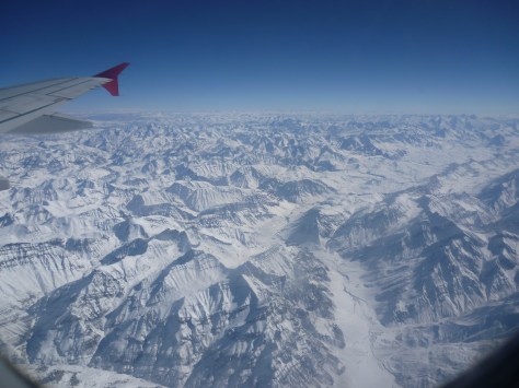
Day 1: It was noon by the time our early morning flight took off from Delhi airport, thanks to bad weather conditions. Just 20minutes after take off, a small but prominent layer of cloud seemed to appear at the horizon.. But within no time, we realised that we were approaching the Himalayas. In just few minutes, the GPS indicated Shimla on the map in the TV infront of our seats. A never-ending stretch of deep gorges, ravines, formed the beautiful landscape below. Few minutes further up.. Yes..!!! we couldn’t contain our excitement of flying over the snow covered mighty Himalayan peaks, we were jumping for a spot at the windows taking turns.. It was the first time we were seeing snow! Click click click…. The cameras went on and on… It was as if we were in an enclosure which was floating up in heaven.. It was absolute FEAST to the senses.. all the way… till touch down🙂

You are flying over the Himalayas...
You are flying over the Himalayas…

Inspite of the glaring bright sun, it was 6 below zero degrees when our flight landed at Leh- one of the highest airstrips in the world. We took a cab to the hotel that we were informed by the trek organiser.

The day went by just making an alternative plan for the trek that could not happen. Also, it was necessary to get acclimatized to a scary combo of High altitude + low temperature(It went upto -25deg on some days of our trip). So we just had to stay bummed to our rooms(without heaters..!!) and warmup ourselves 😛 We shopped for a lot of thermals in Leh market (we got cheap & good quality stuff..)

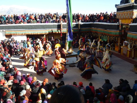
Day 2: It was the last day of the Gustor festival – the annual fair at the Spituk monastery– Enroute we visited the ‘Hall of fame‘- the war museum. We happened to be there at the right time when an Indian airforce carrier was about to land. With the Sham valley & other mountain ranges all around the airstrip, it called for the exact photo that had inspired me to visit Ladakh more than a year ago.. We later headed to the monastery where the day long festivities and mask dance was going on.. We walked up the stairs to the holy abode of Kali(which is open for public viewing only during Gustor festival) before we comforted ourselves by finding a seat amid the chaotic crowd that had assembled. After the event, we did a bit of souvenir shopping at the mela that was put up and a lot of binging on Ladakhi food. We took a cab to Shanti Stupa which is best for sunset viewing. After the sun was down, we took the stairs down which we were told was a shortcut to reach Leh town by foot.

Mask dance at the Gustor festival - the annual fair at the Spituk monastary
Mask dance at the Gustor festival – the annual fair at the Spituk monastery

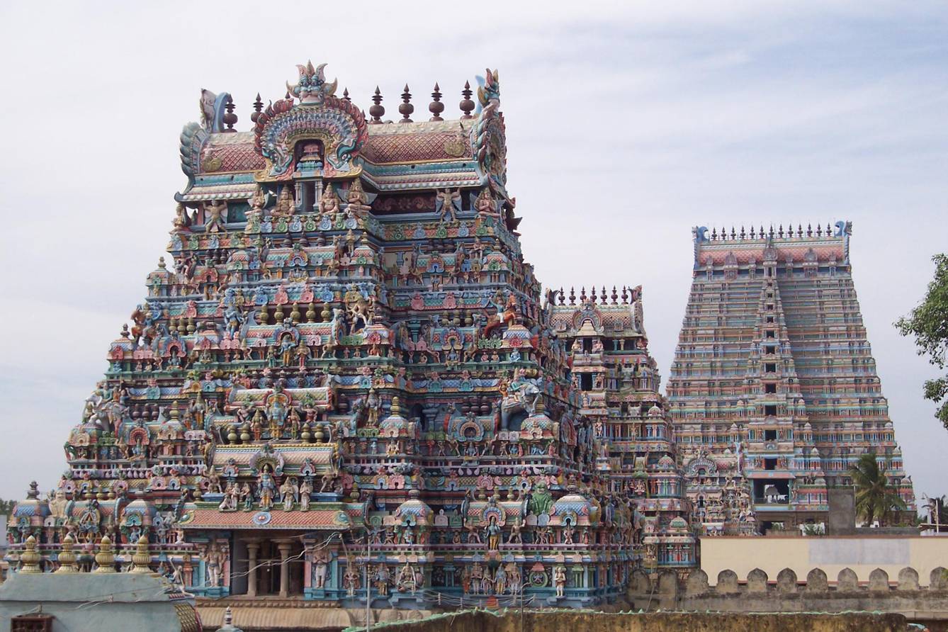
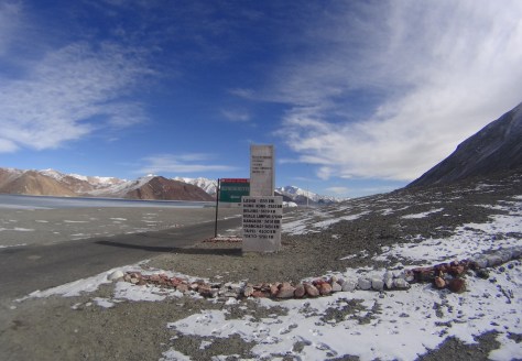
Day 3: Drive through Changla pass(the 3rd highest pass in the world) at a nerve freezing temperature: Get a quick grab of food at Karu town. Here one needs to get the Inner Line Permit to proceed towards Pangong Tso- the controversial border between India & China. The lake was partially frozen- where we could drive over most part of it and experience the chadar partially 😛 If one has an extra day, they could head to Tso Moriri, a salt water lake and camp there overnight before returning to Leh. But, we took back the same route so we could cover the Shey Palace, Thikse monastery & got a glimpse of the Rancho school of the ‘3 Idiots’ fame. Hemis monastery- the wealthiest monastery in India remained unreachable by road since it was winter.

A milestone at the Pangong tso

Day 4: It was a lonng day.. A wonderful drive on a roadless route which seemed to have been carved all out of ice and sprinkled with snow.. A small slip of tyre could get deadly as beautiful as the valley seemed to appear. We couldn’t ask for more when it began to snow just when we alighted at the end of the highest motorable road in the world- the Khardungla pass. Continue on the road that leads to the cold desert of Ladakh- The Nubra valley. With minimal vegetation, and sand dunes all around, you should not be missing out the ride on the Bactrian camels which are endemic to this region and is a critically endangered species. Visit the Diskit monastary- where a 32 feet statue of Maitreya Buddha looks upon Pakistan. Towards the end of the valley is the Siachen glacier- the highest battleground in the world and the glacier forms the source to the biggest irrigation system in the world-The Indus. Catch a good night’s sleep at a traditional homestay there and experience authentic Ladakhi hospitality.

View from a monastary
View from a monastery

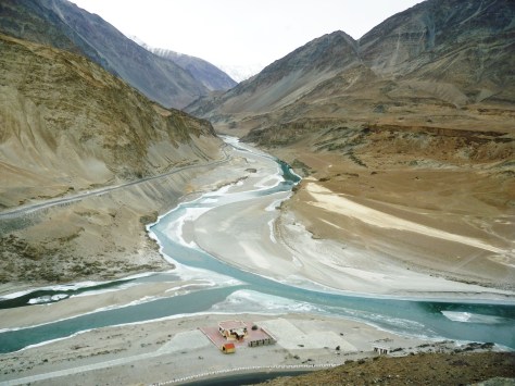
Day 5: Start early cuz the day will be short with too many places to cover on a single stretch from Leh. We took the Kargil road- a drive through Sham valley. First stop was at Nimmoo where we filled our fasting tummies. The next quick stopover was at Pattar Sahib Gurudwara. The straight stretch of road looked as if it was peircing right through the horizon. We were driving through the magnetic hill. The road which is believed to have defied gravity where a car with ignition off and neutral gear moves uphill- against gravity..!! We were not quite convinced with our experience though, which made us agree to the scientific explanation of it being an optical illusion. We arrived at Chilling- The confluence of the Indus and Zanskar. The partially frozen stretch was intimidating to walk over.. But we were warned by a cop not to go near the banks.. all thanks to section 144 😛

The confluence of the Indus and the Zanskar

We continued our journey through rustic Ladakhi villages, monasteries dotting the distant hillocks, frozen waterfalls, bare poplar trees, narrow truss bridges, army barracks, hot water springs, ice hockey fields, etc. We came across wild deers, yaks, pashmina sheep, wild horses and other fauna endemic to this high altitude region.. Likir monastery was beautiful with the Buddha statue smiling in between the snow clad mountains all around. Our last destination was Lamayuru monastery– The start point for many treks in this region.

Unfortunately, we did not have the luxury of a few more hours and safe conditions at the border to go further upto the Kargil border. We wanted to drive back through Drass valley- The coldest inhabited place in India and the second coldest in the world. Again, If I had an additional day in hand, I would have loved to get an inner line permit to spend a day at DhaHanu valley: home to the endangered community of the Dard people. I would love to go back ASAP atleast to document their customs, traditions, photograph their intricate jewellery and costumes before their numbers further deplete. Had I been blessed with a couple more days, I would want to do the Markha valley trek andand experience the tribal life in its raw & purest form.. And spot a snow leopard in its natural habitat at the Hemis national park- the largest national park in India and the highest national park in the world.

During winters, most of the town is shut for the season. The few places that are up, open after 11.00.a.m and close by 5~6.p.m. We missed out on some fine shopping of souvenirs, local handicrafts and dry fruits.. Probably, some form of connectivity of phone or internet could have helped us to cover more places and organise our trip in possibly a better way.. But, NO REGRETS..!! We’ve still done what most people don’t dare to- Experience the bitter winter of Ladakh. That’s all the time we had for.. We had to pack our bags with a super heavy heart to carry back home..

Day 6: It was a rare phenomenon that we had woken up with that day, early at 6.a.m. It was snowing in Leh. There usually is no snowfall at Leh town… But that day I guess the town had started to miss us… the sky was crying heavily.. We reached the airport by 07.30.a.m. The security measures are very stringent for those leaving Leh which easily needs about 2hrs. 2 rounds of passengers’ frisking and 2 rounds of baggage screening. And then, you have to individually identify your baggage until which it will not be loaded to the flight..!! Quite a strenuous task for the security personnel… While it is considered as a fun trip for the touristy people like us.. It’s a salute to the bravehearts : The Indian army.. Who bare all odds like extreme climatic conditions and unpredictable threats to their lives, strive day and night to ensure that we are safe.. The flight took off over the mountainthat said ‘Touch the sky with glory’.. in the true sense…

I will come back ASAP for more..

Julley Leh..!!

Thally- The little England of Tamil Nadu

I had seen the name of this place on the boards of inter-state private buses plying in the roads of Bangalore. On a little bit of research, I came to know that it was a popular summer destination of the British which has twin hills called Devarabetta, with a good view point.

One day, when my friends and I were looking for a destination for a random ride to kill time, Thally popped up in my head. In what was meant to be just a ride to kill time on a weekend, turned out to be a discovery of a new hideout to escape the frenzy of the city..

We used google maps for navigation. A small ride through Jigani, past Chandapura town lead us to a small barricade that marked the Karnataka- Tamil Nadu border. There was a sudden drop in temperature leading to a rather pleasant ride than expected, in an otherwise hot Tamil Nadu.

The colourful brick making kilns

The colourful brick making kilns

Brick making kilns and artistically structures built with raw bricks and tiles dotted some stretch of the bordering village. We proceeded through the serene greens of vegetable farms and yellow blossomed mustard fields to reach the junction of Thally town. The temple fair seemed to be happening beside the huge Thally lake. We thought of giving it a miss owing to the village crowd and proceeded towards our next destination: ‘Devarabetta’.

View of the Twin Devarabetta  hills from the farm lined road
View of the Twin Devarabetta hills from the farm lined road

We were excited as we spotted the twin hills from a distance. We passed through rough countryside terrain and kaccha roads that finally lead us to the temple at the foothill of Devarabetta.

The stairway to Devarabetta :P
The stairway to Devarabetta 😛

It wasn’t a strenuous climb with mere 100+ steps leading us to the top (Read about scaling the second highest monolith in Asia- A day trek in Bangalore) where an ancient temple exists. We took a 360 deg view around and it looked beautiful.. Surrounded by the Anchetty /Bannerghatta forest range on one side, the rocky hillock on another side and green pastures all around.. And a very pleasant weather: This could be why this place was once called ‘The Little England’. We spent sometime soaking in some pure air of the forest cover around and chatting up for a while.

Since our stomachs were growling and there were no hotels nearby to sate our hunger, we decided to head back to the city. (This update is as on Jan-2015. Current condition might be different as the rapid urbanisation and expasion of Bengaluru city limits has reached Thally)

The Vishnu temple enroute to Devarabetta from Thally

The Vishnu temple enroute to Devarabetta from Thally

But on our way back, I found an interesting piece of architecture, I wanted to explore more. We parked our bike and walked into this old temple complex. The door to the sanctum was closed. There was no one around who could throw some light about this place. However, the design looked liked a scaled down version of the temple at Tirupathi, suggesting that it was dedicated to Lord Vishnu. There was an old well, a wooden temple car and a dilapidated mantap adjacent to the temple. Further, with my little knowledge of temple architecture, I recognise that the art had some relevance to the Chola style of architecture (the stairs had resemblance to the Varadaraja Perumal Temple at Kanchipuram & the Big temple at Tanjavur).

Inside the temple premises

I would be really happy if someone could help me out in knowing the actuals about the history of this temple. The map of the temple is shared below.

The forgotten Chola temple- Google maps

Thereafter, we continued our return journey to the city. This place makes for half a day’s outing if you are looking for some solace with nothing much to do, at a stone’s throw away distance from the city. You can make a full day outing if you combine it with a tour to hosur, Denkanikottai fort in Tamil nadu or the pearl valley in Karnataka.

Conclusion Remarks:

Not a great place to plan an exclusive trip, you can consider it only if you’re planning for a random ride on a weekend to get away from the Bangalore chaos.

Places to Visit in Trichy in a day

This visit to Trichy was a part of our family’s backpacking trip, mainly conceptualized to cover a portion of the Coromandel coast during this trip. Our itinerary for this trip was Bangalore – Mayiladuthurai – Poompuhar – Tarangambadi – Karaikal – Nagapattinam – Velankanni – Tanjavur – Trichy – Bangalore.

After a long day exploring Tanjavur, we boarded an evening bus to Tiruchirappalli. Trichy is a name given by the British, perhaps the shortened version of the original used for the ease of pronunciation. After reaching the town, we checked into a lodge in front of the central bus stand, had a sumptuous meal and retired early.

  • It was day 3 of our backpacking. The places covered in our Trichy day trip were:
    • The island town of Srirangam
    • Thiruvannaikaval
    • St. Lourdes’s church
    • Rock Fort

The visit in detail:

Since this was not the first visit to Trichy for my parents, this plan was just a Trichy day trip. They wanted to just go around the major landmarks that are typically frequented on a traveler’s circuit. But Trichy is beyond just pilgrimage and ours is a family of explorers. So, in spite of covering these popular landmarks, we still added a few elements of history and architectural explorations into it to make it more meaningful than just going around these places. In fact, as someone who views places from a historian’s perspective, places are usually recognized by a specific dynasty that had an influence in its overall culture. For example, Mahabalipuram is associated with the Pallavas, Tanjavur or Kumbakonam is a major territory of the Cholas, Madurai with the Pandya and so on. But, when it comes to Trichy, this town was never a capital of one particular kingdom. However, it has remained a very important place throughout history and across timelines, thereby picking up influences of all major dynasties that ruled over this region. Hence, it is safe to say that Trichy represents a confluence of all south-Indian architectural styles.
I would like to elaborate on the places we visited to give my readers a brief idea of these places when they plan their trip to Trichy.

Landmark 1: Srirangam

We got ready early next morning and boarded a local bus to Srirangam- the abode of Sri Antya Ranganatha Swamy. This is the Tamilian counterpart of AdiRanga at Srirangapatna and MadhyaRanga in Shivana Samudra (All three are island towns formed by river Kaveri). Srirangam is an important place of worship for the Vaishnava sect of Brahmins or the followers of Lord Vishnu. When we arrive there, there was a long queue and we managed to get a glimpse of the historic idol of Sri Ranganatha sleeping on a serpent after a long wait in the queue. (There is a long history of how this idol came into being, worth a read).

But pilgrimage aside, we were there to enjoy the architectural marvels of the city. If you are someone who loves to walk and explore a place by foot, it would take a good 2-3 hours to simply walk around the main temple complex. Although the main gopuram or the outermost tower is the latest among all the towers in this temple complex, it is the largest temple tower in the world. With a spread of 156 acres, the temple complex itself is believed to be the largest functional temple premises in the world.

The complex consists seven rounds of walls/fortifications before you reach the sanctum sanctorum. Each wall was added by the successive dynasties that reigned in this town including the Pandya, Cholas, Hoysala, Vijayanagar, Pallavas and the others. The art specific to each of these eras can be noticed in the complex. The entire complex has 21 temple gopurams where one could easily get lost in the vastness of the complex if attempting to see each of them individually. After entering the main complex, a ticket of Rs.10 per head took us through narrow stairs leading to the roof of the temple. This is called the temple viewpoint, from where all 21 temple towers could be seen from a single spot. There is also a 1000 pillar hall which was earlier used as a venue to host dance events, now remained locked. We admired the fine sculptures on these pillars through the bars of the closed gates and continued our walk further.

The Antya Ranganathar swamy temple at Srirangam

The banks of river Kaveri is just behind the temple, which can be accessed by walking through the rear door of the temple. With blazing sun even at 10.00.a.m, the sand and the asphalt road were already heated up. Hence, our barefooted attempt to walk to the riverbank was less a walk and more a run. Hailing from a place where the holy river originates and flows gracefully with water all through the year, it was unexpected and disappointing and to see her riverbed running TOTALLY dry in this part of her journey. But after talking to the localites, I cheered up a bit as they were looking forward for a good monsoon in the coming month. We were told that the river would flow almost in spate during the monsoons (Even submerging the very place that I was standing at). We came back to the temple again, had some fresh fruit juice from one of the stalls outside, wore our footwear and took a walk around the temple.

Big houses, with very small entrance, compactly built next to each other, allowing no or very less ventilation inside was the trademark style of Srirangam. These streets take pride in being home to one of the highly educated communities of the country- the Iyengar Brahmins.

Oh yeah…!! It was BURNING hot and I was pretty sure I’d go back home like a grilled chicken after this walk. But then, we wanted to make the most of the visit because life is uncertain, and no one knows for sure when we would be visiting again.

Landmark 2: Thiruvannaikaval

Though the population of Srirangam mainly comprises the Iyengar (the followers of Vaishnavism), the then rulers have also built temples for the Iyers (the followers of Shaivism). Hence, our next destination was to see the temple built for Lord Shiva. We boarded a bus to Thiruvannaikaval. This temple is as beautiful as the Ranganatha temple, however, the history behind the latter has made it more prominent. Though many people visiting this city give a miss to this temple, it should be noted that this is one among the five temples built for Shiva representing the five elements of life. This one represents water or Jala Linga. One of the residents in the complex noticed our interest in exploration and suggested us to visit the Amma or Parvathi temple, another beautiful ancient temple usually missed by visitors. It is located right behind the Shiva temple.

The entrance to Thiruvannaikaval Shiva temple

Landmark 3: St. Lourdes’s church

From the temple, we had a nice south Indian meal at a nearby hotel after which we headed back to Trichy town. We visited the St. Lourdes’s church in the city. The Gallo-Catholic design of the church architecture and the neo-Gothic spires are beautiful in this early 2 centuries old heritage structure.

St. Lourde's church
St. Lourde’s church

We did a bit of shopping in the by lanes and the Trichy market around the Teppakulam (Temple tank) before we started our ascend to our next destination.

Landmark 4: Rock Fort

This single projection of land in an otherwise low/Flat Trichy town dates back to the pre-historic era. It is beyond words to describe how in those days, could someone has created such beautiful structures out of a hard monolith. What appears to be just a random protrusion of earth from outside, is in fact a haven for the art lovers in the inside. There are stairs, numerous temples, artistic pillars and idols carved out of the same rock all the way up. There is a Ganesha temple at the summit from where one can enjoy the view of the entire Trichy town, the Kaveri river flowing around Srirangam, the temple gopuram, the rail lines traveling in and outside the city. The fun was doubled by the cool but strong winds that blew taking away all the tiredness from our minds.

The view of river Kaveri from the summit of Rockfort
The view of Srirangam and the river bed from the summit of Rockfort

As we decided to descend down, we realized that a door that had remained closed during our ascent was now wide open. There were some beautiful paintings peeking out of the door intimidating us to go inside and see what was there. We stepped inside and it was amusement that followed. It was a vast hall carved out inside the same rock with beautifully sculptured pillars and amazing paintings adorning the walls. A priest noticed our interest and started explaining the story depicted by each painting. He then told us to hurry up and walk inside through another door. There, the maha mangalaarthi (the last pooja of the day.!!) for goddess Parvathi was just about to begin. Just as we reached there, they unveiled the curtains for us to get an eyeful of the beautifully decorated goddess.

Just while we were sipping the holy water, we were again asked to rush through another door, cross a narrow chamber that led to the Shiva temple. The deity was getting ready for the final pooja of the day. Prayers are offered only thrice a day: During sunrise, at noon and before sunset. And we were lucky for being there for one of these (the last one). The curtains were parted from the deity and the huge idol was being bathed in the pancha-Amrutha. Then, he was neatly dressed in dhoti, decorated with fresh flowers and the pooja culminating with Arathi. The curtains were back signaling us that the god would then go to sleep. We felt truly BLESSED…!! by the end of this, I could see my mom weeping in joy for being lucky to witness this Pooja. We had witnessed an event that was so unexpected.

At the exit of the Cave temple / Rockfort

Again, the presence and strong hold of almost all major south Indian dynasties could be felt there with the exquisite designs present in the art there. We thanked the priest and took leave to descend the stairs leading us down to the market.

Landmark 5: GR restaurant

A final destination to our tour: a local recommendation for an evening chai. GR restaurant is housed in an old building in the heart of the city (enroute to Rock fort). The Valli appam is a must try here. The interiors of the hotel are commendable which has rock pillars, structures & collectibles that reminds one of the grandeurs of temple architecture that this region is renowned for. A cup of piping hot filter coffee was a grand ending to our Trichy day trip!
There are many lesser known temples around Trichy and equally beautiful with rich artwork which takes up another full day. But one day was all the time we had with us before wrapping up trip in Trichy to Bangalore. So, I shall come back soon.

A secular pilgrimage along the Coramandel coast

This was a family backpacking trip, mainly conceptualized by my dad and had been long due. He wanted to see how the end of River Kaveri; our family deity looks like. Accordingly, we made an itinerary and a route map. Our family of four backpacked with the below itinerary:

Our Itinerary:

Day 0: Depart from Bangalore (Travel mode: Overnight train to Mayiladuthurai)
Day 1: Visit Poompuhar, Tarangambadi, Karaikal, Nagore and Velankanni (Travel mode: local bus; Stay: Church run lodges at Velankanni)
Day 2: Explore Tanjavur (Travel mode: local bus; Stay: Hotel at Trichy)
Day 3: Explore Trichy (Depart to Bangalore by overnight bus)

The first day of our backpacking is presented here, which took us across three important landmark destinations along the east-coast, covering all three prominent faiths in India. That’s why I call this part of the trip as a ‘secular trip’ with of course covering the intended destination: Poompuhar, the end of the River Kaveri or the point where this Holy river meets the sea.

Destination 1– Poompuhar

The name reminds one of the arts and crafts of Tamil Nadu while Cauvery emporium strikes a similar bell back home at Karnataka. The link for both the names is common. While the latter relates to Tala-Cauvery, the birthplace of river Cauvery at Karnataka, the former marks the end of the same river at Tamil Nadu. Both being holy places for the Hindus of South India.

We were welcomed by a stretch of fishermen selling salted/seasoned & dried fish at the shore of this historic beach. There is a sculpture art museum on to the right side, at the entrance. To the left is Ilanji Mandran, a bathing place said to have had mysterious powers of curing health ailments that dates back to the Chola era. A walk for about a kilometer along the roaring sea leads us to the river mouth. It is believed that river Cauvery (a female) runs towards the sea (a male) at this point. If one stands and watches the river mouth at this point, the rapids of the river joining the calm sea can be seen quite evidently. The calm sea lashes her back towards the land with his waves side by side. A dip at this juncture is believed to be very holy (Hailing from a community that worships this river as a family deity, at least this is what I have grown up listening to). This place is also called Kaveripoompattinam as called by the Cholas and is a place of importance to the archaeologists.

The Ilanji Mandran at Poompuhar

Apart from the river mouth and a walk through the historical monuments mentioned above, there is nothing much to do at Poompuhar otherwise. The Kethu & Budha sthalams among the Navagraha temples are close by- I will save them for another article.

With that, we boarded a bus to our next destination- Tarangambadi. Then from there, to Karaikal beach.

Destination 2- Nagore

The little town of Nagore is known for the Hazrat Syed Shahul Hameed Dargah of the Islam faith. We were welcomed warmly by the priests there who helped us with the procedures of offering our prayers. Going by history, this dargah stands as a symbol of peaceful co-existence between the Hindus & the Muslims as people from all faiths come here for worship. There are 5 minarets out of which the tallest one was built by a Maratha King of Tanjavur for being cured of his ailment by the miracles of Shahul Hameed. From there, we headed to our last destination of the day.

One of the 5 minarets at the Nagore dargah

Destination 3: Velankanni

It was sunset time when we arrived at the Catholic shrine of Our Lady of Good Health. We walked through the lines of stalls bustling with activities, pilgrims, tourists, hotels and other urchins to reach the seashore. This place is so crowded almost all through the year, that if one just stands in the crowd, the crowd will take you forward without you actually having to try to walk. We walked back to the Basilica of the Arogya Matha as she is fondly called to offer our prayers. The history dates back to 3 events occurring from 16th century onwards where Mother Mary appeared to a milk vendor, a buttermilk vendor and the Portuguese sailors who survived a severe sea storm. There is Matha Kulam / the holy pond and 2 chapels built at the respective places of the above occurrences.

We then took a brief walk at the donation’s library where all the gold, silver & other expensive offerings made by the devotees are kept for exhibits.

The shrine of Our Lady of Good Health at Velankanni

With that, a tiring, yet a pleasant journey in quest of god ended in a peaceful slumber at a Church run lodge… The following morning, we board another TNSRTC bus to our next destination: Tanjavur.

Offbeat Places to See in Tanjavur on a daytrip

This visit to Tanjavur was a part of our family’s backpacking trip covering the route: Bangalore – Mayiladuthurai – Poompuhar – Tarangambadi – Karaikal – Nagapattinam – Velankanni – Tanjavur – Trichy – Bangalore.

Following a long day of a secular pilgrimage in the Coromandel coast, we boarded a morning bus to Tanjavur. Tanjavur, the cradle of Dravidian culture and a hub of the Chola art and architecture needs no introduction. There’s no dearth for information on the internet. A visit to this land was on my parent’s ‘bucket list’ and this was a trip planned for its materialization. With a day’s time at our disposal (VERY short for a slow traveler like me), we decided to cover the major landmarks that a typical tourist would want to see in the capital of the Cholas.

It was the second day of our backpacking. The places covered in Tanjavur were:
• BIG temple (Brihadeesvaran temple)
• Saraswathi Mahal complex
• Grand Anicut / Kallanai dam

The details:

As in case of every other civilization, a river holds all the life. In this case, Tanjavur was born on the fertile delta created by river Kaveri. This is the land that has nurtured and held on to the Dravidian culture till date. Apart from this, its local economy has largely been agrarian based ana is rightly called as the rice bowl of South India.

Landmark 1: The Big temple

The iconic monolith of this land was spotted even as our bus was still pulling off at the bus station. The monolith seated gracefully atop the ancient temple with a weight of 800 tonnes was still far away. As we reached, we stood there in awe, gazing at the vast premises of the mighty temple. The temple tower is the tallest in the world and stands testimony to the Cholas’ love for art and fine engineering skills even in the iron age. It is believed that a ramp was laid from about six kilometers to facilitate the placement of the monolith Kalasha atop the tower. The walls of the corridor are adorned by fine paintings that were done with a mixture of limestone and organic extracts. The temple walls have sculptures of numerous mythic animals which is the highlight of the Cholas’ temple architecture.

The entrance at the Brihadeesvaran temple

‘The Great living Chola temples’ is a group of three Chola temples located across Tanjavur district. Together, these three temples represent an architectural conception of the pure form of the Dravidian style. The Tanjavur Brihadeshwara temple is the most easily accessible of them all and is located in the heart of the city. (The other two temples are the Airavatesvara temple at Darasuram and Gangaikondacholisvaram). Although the Brihadeshwara temple is fondly called as the Big temple, it has multiple names. With a simple translation of the name into local language, it is called Thanjavur Periya kovil. The great Chola king Raja raja named this temple as Rajarajesvaram and the deity Shiva in Linga form as Peruvudaiyar. A few people also refer the temple with the name of its deity as Peruvudaiyar kovil.

The Tanjavur paintings adorning one of the roofs

Landmark 2: Saraswathi Mahal complex

We took an autorickshaw ride from the Big temple to Saraswathi Mahal. This is reckoned among the oldest functional libraries in the world and was patronized by the Tanjavur rulers. One can find some very old, rare and original copies of important manuscripts, scientific research publications etc. here. Adjoining it, is the palace of the Marathas of Tanjavur. The palace is partially used as the residence of the descendants and remaining portion is converted into a museum.

Behind this building, is the art museum which houses some rare and famous bronze idols created during the Chola era. The Cholas were the earliest people to have used the lost wax technique to create the bronze idols with a very scientific approach (as per the documented procedures in the Vedas).

The Saraswathi Mahal Library

Just outside the museum, we picked up a pair of Tanjavur bommai from the souvenir shop. These famous Tanjavur dolls are colorful handcrafted figurines where the head is suspended on a pivot which gives a dancing/swinging movement to the doll. Hence, they are often referred as the Tanjavur thalayatti bommai or the dancing headed dolls. Another artform you cannot ignore or miss while in this city are the Tanjavur paintings. Considered as a divine artform, with gold embellishments, Tanjavur paintings are considered as a symbol of royalty.

Landmark 3: Grand Anicut / Kallanai dam

From there, we boarded a local bus to reach Grand Anicut (as called by the Britishers) or Kallanai (the local name). This is a standing example of the engineering marvels constructed over 2000 years ago by the Cholas (later modified by the British). This oldest functional water regulation structure in the world is a dam constructed with uneven stones / random boulders across river Kaveri with a desperate intention to divert the water before joining the sea so that it can be used for irrigation around the delta region. This dam divides the river into four streams known as Kollidam Aru, Kaveri, Vennar and Puthu. Later, the Lower Anicut/ Kollidam was constructed by the British before the water actually joins the sea.

An epitaph at the  Grand Anicut
An epitaph at the Grand Anicut

With this, our time in Tanjavur had almost come to an end. On the other end of the dame, we sat inside a local bus and waited for it to start to our next destination on our trip: Trichy.

Visiting the Niagara of Karnataka- Gokak

This is a pick from old memories of exactly a year ago, in August 2013. My mother was away in Belagavi for a month-long business trip and I had decided to catch up with her over the weekend. We then got together, and explored the places around Belgaum, fondly called Belagavi. This time, it was only a day trip around Belgaum with a quick visit to the widest waterfall in my state, the Niagara of Karnataka.

Our Itinerary:
Friday: Overnight journey from Bangalore to Belgaum
Saturday: Explore Gokak (waterfalls, hanging bridge & Tarakeshwara temple), Godchinmalki waterfalls, Savadatti Yellamma temple)- Return to Bangalore by night journey.

The Details:

I boarded the bus to Belgaum from Bangalore and my mom was there to receive me when I alighted there the next morning… We freshened up at the place where mom was put up and then headed straight to Gokak. The little town known for its cotton mill, is also famous for the nature’s treat- the mighty Niagara of Karnataka. The bubbling, roaring and crashing waters of the Ghataprabha river creates steady patterns here with endless rhythm while it leaps down from 52meters between two tall, craggy cliffs to form the Gokak falls.

The century old hanging bridge, the only mode for the textile workers to cross the river allows the public to enjoy the breathtaking vista of the waterfall as the gushing water plummets down. The presence of turbines dating back to 1885 stands testimony to the electricity generation station established here which still provides power source for the cotton mill across the street. The 11th century Shiva temple dedicated to Lord Mahalingeshwara (Locally known as Tarakeshwara temple), built in the Kalyani Chalukyan style, faces the cotton mill and flanks one side of the gorge.

Above: The front view of Gokak falls from the Volkart view point; Below: A view from the Hanging bridge.

Meanwhile, I called a friend of mine who hails from Belagavi district to enquire about other places that we could visit around his hometown. He guided us to a small village named Godchinmalki where river Markandeya cascades down amid a scenic backdrop forming another beautiful waterfall called by the same name. Mom and I walked down for 2kms through rolling green pastures, fields of maize and banana plantation to reach this waterfall that plummets down in 2 tiers. Once we reached the place, it was a thorough treat to our senses to watch the waterfalls racing ferociously through the deep gorge.

On our way back, we took a little longer route from where we got a complete view of river Markandeya snaking through the greens. A 9kms long underground canal carries water from the river across which can be seen emerging out of the hill from this viewpoint. The snaking roads with beautiful views of the valley was a wonderful drive to the city.

Top: The Godchinmalki waterfalls; Below: The Gochinmalki view point from the main road

After all the waterfall hopping was done, it was time for some temple visit. We headed to Saundatti a.k.a. Savadatti. This place was the capital of the Ratta / Rastrakuta dynasty from 820, until it was shifted to Belgaum in 1230. There is a fort here also called the Parasgad fort. But the most famous is the Renukadevi temple located atop the Yellamma gudda. This is an important place for devout followers of Goddess Shakthi and also for the devadasis- or the servants of god. We had a good darshan during the evening pooja time.

Savadatti Yellamma temple

With that, it was a quick wrap for a short weekend and time for me to head back to Bangalore for another long and boring work week ahead…

Must eat while at Belagavi/ Belgaum:

  • Karadantu at Gokak– it is a sweet made with dry fruits rolled into balls with jaggery.
  • Kunda at Belgaum– This is a sweet made with milk.

The land of the singing waves – Tranquebar

This visit to Tarangambadi was a part of our family’s backpacking trip, mainly conceptualized to cover a portion of the Coromandel coast. Our itinerary for this trip was Bangalore – Mayiladuthurai – Poompuhar – Tarangambadi – Karaikal – Nagapattinam – Velankanni – Tanjavur – Trichy – Bangalore.

This post is about destination no.3 on the first day on the east coast road. I had read about this place in one of the history texts about the Colonial empire in India. I had visited Portuguese, British and the French settlement towns during my earlier travels. The Danish colonized in India for over 200 years with three important settlements. Serampore (in West Bengal), Tranquebar (in Tamil Nadu) and Nicobar Islands (in Andaman & Nicobar Islands, all along the Bay of Bengal. To read about the existence of these places in modern day’s context, there was barely any information available online from a traveler’s perspective. Since we were anyway doing the ECR tour, my curiosity to know more about a Danish settlement motivated me to add Tranquebar in our itinerary. ‘Tranquebar’ as the Scandinavians called it, is a humble town known as ‘Tarangambadi’ in present times.

As we continued our secular pilgrimage, I bought tickets to a destination that was unheard of to my family until that moment. I requested the conductor to inform me when we arrived there. Accordingly, we alighted the bus at a small junction. The place looked very laid back, simple, untouched by any major developmental investments, just like any other fishing hamlet on the coasts of India. The bus conductor pointed to a small road to the right and guided us telling “one kilometer ahead is the fort”, and blew the whistle indicating the driver to proceed. My parents looked at me with a blank look on their face. I could sense that ‘Where are you taking us on this hot afternoon?’ question in their eyes. Although with the first look of the place, I too had similar apprehensions running in my mind, I wanted to walk further to see what was really there!

We walked for about half a kilometer and an old arch done with Danish art welcomed us at the entrance of the town. A board by the side of the arch read: ‘Welcome to- The land of the singing waves- Tranquebar’.

The entrance arch
The arch at the entrance of Tarangambadi/Tranquebar

As we walked through this town welcome gate, the feel of the place transcended us instantly to a different country, or a different era- perhaps. The roads were super empty & clean and old Danish buildings stood tall on either side of it. The Zion church, the Teresa’s convent school, the Danish governor’s bungalow among several other structures that tell tales of an era bygone finally led us to a fort. ‘Fort Dansborg’ as it is called, is a structure peacefully nestled on the calm shores facing the Bay of Bengal. The moment we got a glimpse of the beach from the fort entrance, we got the link to the name of this quaint little place- Tranquebar: the land of tranquil waters. The place had tranquility overloaded not just in its waters, but in its air, land and whatever we saw around. I’m usually not a beach person, but this place was magical!

Since there are just countable properties (heritage bungalows turned resorts) in the town, Tranquebar is still unconquered on the tourist radar. Also, the unavailability of affordable food in a long stretch of kilometers, the budget hoppers are those who just drop in for day trips. Hence, except for a handful of fishermen, evenings and early mornings are idyllic with you being your only company if you choose to take stroll along the calm beach. This is by far, one of the BEST beaches along the east coast that I have been to.

The serene shoreline at Tranquebar
The serene shoreline around the Tranquebar fort

The fort is well maintained and converted into a museum. An important port between 1600s to early 1900s, the walls of the port now lay dilapidated, majorly battered by the tsunami in the year 2004. A stroll along the beach take you to the Masilamaninathar temple. It dates back to 13.C.E. and is believed to have mythological importance. The sculptures on the walls of this temple and the shikara have been corroded by the salts.

Although there isn’t much to see around in Tranquebar, it was a place that filled our mind with peace and tranquility even with just a few hours spent there. My parents too, were equally excited about the place where I had brought them to. I must admit that Tarangambadi is a place that I would COME BACK soon. Then, with more time and a hotel reservation at one of those bungalows on its beaches. But for now, it was a hard but a helpless option for us to pull ourselves out of this place. Unsatisfied with the quick visit, we promised ourselves to come back exclusively to stay here as we left for our next destination- Nagore.

Mission accomplished- Kumara Parvatha

This trek was planned to celebrate the 1st anniversary of Sam’s farewell trek (Click here for details).. on the same day, exactly a year ago..

Let me get you going directly from where this trek to Kumara parvatha or KP peak is actually supposed to start. We reached Kukke Sri kshetra and checked into the lodge(a meagre 100Rs. Per day) run by the temple trust, freshened up and feasted on some sumptuous Mangalorean food for breakfast. Without wasting much time, we started the much hyped- one of the toughest treks in South India.. to the Kumara parvatha peak in the Pushpagiri wildlife zone.

The original plan was to start from the base by 7.00.a.m and camp at Bhatru mane. Then, leave Bhatru mane by 3.00.a.m the next morning and reach the peak to witness the sunrise, what is supposedly one of the best.

As planned, we entered the trekking trail.. It starts off with thick forest around and steep climbs uphill.. There was NO water sources along the way (We didn’t know that there was a perennial stream, with a small deviation after 2.5km) and a possibility of occasional encounters with elephants. We took frequent stops before taking a longer halt at Bhima’s rock. This stretch of 3km had oozed the fluid out of us..

 A view from Bhima's rock
A view from Bhima’s rock

Once this 3kms stretch was covered, we got our first view of Kukke town.. The thick canopy of forests made way to the grasslands after walking 1km further from there.. It was well past noon and the sun shined at its hottest.. We were running out of water already.. We started to wonder if Bhatru mane really existed and literally pulled ourselves to reach there. Or rather say, we pushed ourselves to walk the small distance that seemed never ending.. Finally… we were overjoyed at the first glimpse of Bhatru mane…

The first glance of Bhatru mane

We ran down to his nestle amid a small piece of green land.. I find NO words to express the joy of finding water.. That too, clear and cold water from the stream that ran through his farm.. We had a simple, yet the tastiest lunch served by Bhatru and rested under the shades of his arecanut farm..

We then made a small change in the plan and decided to continue the trek until it was dark. We feared the pace at which we were climbing up and did not want to return late on the following day.. We halted at a view point along the way for some photographs, before reaching the forest checkpost. We continued our hike up after registering our names at the forest office.. We stopped again at yet another view point.. The sun was coming down by the time we reached kal-mantapa and hence we decided to pitch our tent near the stream that ran by..

The sunset from our tent

The sunset from our tent

I don’t remember which sane person in the group chose the place.. I agree that we got a place which became every other trekker’s envy.. The place was for sure, a top rated spot for sunset viewing.. But we girls, who stayed inside the tent know what we went through that night.. The tent was pitched on a slope, on the edge of a rocky cliff which seemed like the place where the earth ended.. It was soon dark and we ate the little food that we had carried and hit the bed (Read hit the rocks)..

The boys comforted themselves in their sleeping bags and threw the poor girls inside the tent.. The entire night went by like this: ‘Our respective backpacks were used as pillows inside our tent. We all would slide down with our bags inside the tent.. again we would push back everything and move up.. Slide down.. Slide up.. Phew..!!’ And a while into midnight.. The intensity of the wind also increased.. The cover of the tent started to fly.. We hoped for it to be 3.00.a.m soon so that we all could start our ascend.. But another surprise was awaiting us.. Madhu heard the cracking sound of the tent support and scared all the girls inside to vacate the tent. We carried our luggage from inside and jumped out of the tent, one by one.. The last girl just came out and the tent crashed down to a flat.. The guys woke up and one of them attempted to slowly remove the pegs.. One peg was removed and then… The tent flew.. away from our reach.. off the cliff.. down the valley.. We had borrowed the tent, on hire.

Everyone woke up and sat wondering why this had to happen. It was still dark at 4.00.a.m. and with the wind that continued to blow ruthlessly, our ascend to the peak seemed impossible.. We stayed back until sunrise 😦 We decided to compromise on one of the main agenda of our trek- Watching the sunrise at KP peak.

After there was dawn,one of the boys dared to go down the cliff. He had a thrilling feat with adventure and managed to bring back the tent that had settled on a boulder in the middle of a water body, down below in the valley.. More than getting excited about finding the tent, we were all celebrating his safe return.. It was around 7.00.a.m by the time we started our ascent.

Inspite of missing the sunrise, the views post that period were equally spectacular, all along the way. The climb was pretty smooth. It was around 11.00.a.m. by the time we reached the first peak/ false peak- Shesha parvatha.

Post sunrise

The view from the base of Shesha Parvatha

After just a few photo moments, we decided to continue our journey.. We descended the steep rock and waded through super cool, thick jungles.. And then, climbed up another steep rock. This rockclimbing with bare hands and legs reminded me of our monkey ancestors.!! A small walk further up took us to the actual end of the earth. Right there, we had conquered our destination- Kumara Parvatha..!!

Shiva temple atop Pushpagiri hill

Shiva temple atop Kumara parvatha

Thanking the diety with a small bow in the temple on the peak, we set our return journey.. Getting down the rocky slope of KP seemed tricky with one of my friends ending up with torn trousers when he decided to sit and slide down on his butt 😉

The descend from Shesha Psrvatha was no easy task either. The loose gravel all along the trail made walking difficult without slipping. It was 4.00.p.m by the time we reached Bhatru mane.. We realised that we had covered only half the distance and had very less time left with sunlight.. We had to complete the remaining distance before it got dark because that was the toughest stretch with thick forests and wild animals. We had a quick lunch at Bhatru mane and got some rest in fast forward mode and started our descend by 5.00.p.m..

We knew we had very less time in hand and a LONG way to go.. We all walked as fast as we could. Our legs had given up already.. I was preparing my mind to stay back in the forest and make a feast of myself to some wild animal at night.. I ran down the slope at times.. My knees seemed like they would part away from my thighs.. We saw the sun coming down.. We continued to walk fast.. We saw the sun going down the horizon.. We paced up.. Suddenly we all halted.. There was pin drop silence.. We realised that some wild animal(mostly elephant) was somewhere around.. It took us a few minutes to feel the sound move away from us.. Then, we resumed our walk. We saw the bright day fade into darkness and every shade in this process. The toughest and the last stretch was almost coming to an end.. We had FINALLY reached the KP gate… And the last ray of light too waned into darkness.. Thus came an end to the KP trek- a mission….. accomplished..!!

We all then freshened up at the same lodge and did a quick visit to the Kukke temple before hitting the roads on our return journey.

NOTE: The above story is written based on my trek back in 2013 when there was no restriction on camping in the entire trail. As on 2019, camping is allowed only around the forest checkpost and Bhatru mane. So, it is wiser to plan the distance, hiking time and camping accordingly.

Must do things/ Highlights of Kumara parvatha trek:

  • Bhatru mane is the ONLY place you will find food and it is an experience in itself to get your turn in the queue to have your meal served. The same basic rice and sambar is served for all 3 meals and nobody complains. Not tasty, but finding food after a long day is LUXURY here. Bhatru has a fixed time for serving food and very punctual. The crowd is huge especially on weekends and the wait for your meal can take longer if you dont have your own plate.
  • The sunset from the view point enroute forest checkpost or Kal-Mantapa
  • To watch the Sunrise from Kumara parvatha is like going to a different world. Try to make it there in time.
  • The sky is in its clearest form and star gazing at night is a whole different experience. You see so many stars, bright and clear that it feels as if the sky has moved closer to earth. We got lucky as it was also a night of a meteor shower, so we saw many shooting stars.
  • Drinking water from the stream felt like nectar. So clean and tasty. You can fill your bottles at 4 places along the way. First after 3kms, near the Bhimas rock. Second, at Bhatru mane. Third, at the forest checkpost. Fourth, at a stream just before kal-mantapa.

Of pre-monsoon showers and coffee blossoms

It is that time of the year when the entire hill station awakens with the fragrance of the blossoms.. On the ninth day after the 1st pre-monsoon showers, the coffee plants around the hills of Kodagu will be in bloom..

P1000890

It is an annual spectacle of nature whose occurance is unpredictable and is wholely dependent on the pre-monsoon showers. If the rain fails, it creates some sort of panic among the growers who then resort to artificial sprinkling sytems.. Be it rain showers or irrigation, in either case, what follows is something that one must experience atleast once in a lifetime..

White bunches of coffee blossoms adorn the trees as if some one has strewn cotton all over the hills.. And these flowers last for a maximum of 24 hrs which makes it even more special.. And like the saying goes.. You HAVE to be at the right place at the right TIME to see the right thing happen..

Have you experienced the fragrance of coffee flowers?

Explore the Best of Valparai on a Weekend

My friends and I had heard sufficiently about the rich wildlife of the region surrounding Pollachi, its beautiful sceneries and perfectly trimmed tea estates. Valparai is a lesser known hill station in the Indira Gandhi Wildlife Sanctuary (earlier known as Annamalai Wildlife Sanctuary). Kollywood stars and burnt out urbanites frequent this place to de-stress themselves and savor a slice of nature. Here, as one ambles past mud walled, thatched roof dwellings, granaries of farmers and tea estates fringed plateau, don’t be surprised if you happen to hear someone screaming ‘start camera’, ‘action’. This is a hot spot for movie makers with over 1500 movies and commercials having been shot here. And we too got lucky when we happened to visit the sets and share our homestay with the crew of the movie- ‘Madras cafe’ during this trip of ours.

A weekend itinerary was primarily planned by one of my friends and a few must-see items were pushed into the plan by me. Since this place falls on the border of Kerala and Tamil Nadu, we decided to make it a three states’ drive including Karnataka. Accordingly, five of us started from Bangalore on a Friday night. Since it is also a bio-diversity hotspot, I had listed 5 animals on my ‘to-spot’ list while at Valparai. Valparai is the end destination after driving through 32 hairpin bends. Being a hill station, Valparai weather is specifically delightful with a cool climate throughout the year. It is usually the road leading to Valparai that is enjoyable with scenic vistas and photo-points. I had enlisted them with day 1 in the Tamil Nadu side of the sanctuary and then spending the second day on the Kerala side of the forested land.

Itinerary:

Day 0: Leave from Bangalore by night (Own car)
Day 1: Reach Pollachi before sunrise. Backwaters of the Aliyar dam, monkey falls, Loam’s viewpoint, Carver Marsh viewpoint, Congreve falls, Vinayagar temple, Birla falls, Balaji temple, Iraichalparai falls, Nallamudi Pooncholai viewpoint, ChinnarKallar hanging bridge trek, Sholaiyar backwaters (night stay at a homestay in Chalakudy)
Day 2: Athirapally falls, Vazachal falls and return to Bengaluru via Ooty.

The details:

Part 1: Tamil Nadu

During the night journey, I had dozed away on the rear seat of the car. When I opened my eyes to the misty morning dawn, our car was greeted by beautiful countryside with tree-lined roads, emerald fields of paddy, whispering palms and coconut plantations in the backdrop of the towering Western Ghats. We had reached Pollachi in Tamil Nadu. We waited near Aliyar park until 06.00.a.m. for the forest check post to open.

a. We registered our entry into the wildlife sanctuary there and proceeded on our journey. Our drive further towards Valparai, was an ascent along the winding road by the backwaters of the Aliyar irrigation dam.

View of the Aliyar backwaters

b. Four kilometers further from the forest check post, we reached the monkey falls. The waterfall is aptly named due to the many troublesome monkeys here. One even entered our car and happily carried away a bag full of fruits from the rear seat. Our drive continued…

c. Just as we approached the 9th curve (the Loam’s viewpoint), we were greeted by this gentleman who was calmly grazing on the edge of the steep rocks.
We scored off the first member on our list of top 5 wildlife to see- ‘The Nilgiri Tahr’.

Nilgiri Tahr – Photo credits: Samson Joseph

d. Continuing our drive, we stopped at Carver Marsh viewpoint adjoining the Kavarkal estate. On a clear day, we were told that one can see the Sholayar reservoir (2nd deepest dam in Asia) from there.

e. We then cruised past the Tiger valley from where we caught a good view of the upper Aliyar reservoir.

At the entrance to Sholayar / Kallyar estates

f. We covered Congreve falls (located in the Nadumalai estate), Vinayagar temple (Jayashree estate) & Birla falls along the way up. We got good view of the Manopally forest and the grass hills of the sanctuary.

g. Ox-bow lakes situated inside the protected area is supposedly the highlight of this region for those who can manage to get permission from the forest authorities. We failed at it since we didn’t have insufficient information on the channels for the permits.

h. We visited the Balaji temple and the nearby Iraichalparai falls along way.

Just along our way, it was time to score off no.2: groups of ‘Lion tailed Macaque’ were walking all over the road and around. Even before we realized, we had reached the hilltop.

Lion Tailed Macaque- Valparai

i. We stopped by and trekked through the tea estates to reach the ‘Seen god shrine’ at the Nallamudi Pooncholai viewpoint. An old man, who claims to have seen god, blessed us with some prayers and turned out to be an encyclopedia of knowledge about the local culture and history. He explained to us about the various tribal settlements in these hills… pointing out at colonies, he would tell- Kadars, Muthuvars and Malai Malasars. They are estimated to have 190 households in 8 settlements in the sanctuary.

While we walked towards our car, the women picking tea shoots warned us not to proceed further. She pointed at a herd of 8-9 elephants feasting around at a distance, thus scoring off no.3 on my list.

j. We then drove to ChinnarKallar for the hanging bridge trek. In spite of driving all the way, we refrained from shelling out 250 Rs. per head just for the entry which sounded to us more like a bribe at the forest check post. This place is among the highest rainfall receiving areas in India. No doubt that the Valparai weather is pleasant all through the year and is an upcoming weekend destination among the urban crowd of the nearby metro cities.

We put our car in reverse and just then… no.4: The giant flying squirrel (a young one and wasn’t flying though) crossed our road. We were excited…!!

k. After covering places in the Tamil Nadu part of the sanctuary, we headed towards the Kerala border. We saw a calm stretch of the Koolangal river and decided to spend some time there. We could not compel ourselves from not taking a sip of its crystal-clear waters.

And right there. we saw this little creature on no.5: ‘The common map butterfly

The Common map butterfly

Part 2: Kerala

We registered at the border check post and prepared to enter the Kerala land. Thick rainforests on both sides accompanied us all the way till our destination. We happened to drive through what I think is one of the dangerous roads I have been through. With the Sholaiyar backwaters on one side and a valley on the other side, only one vehicle can pass at a time. Beautiful views for most of the stretch kept us in an awe. Tunnels have been bored through the mountains to supply water to Parambikulam reserve from the Nirar dam.

We reached Athirapally reserve just after sunset. We got a quick glance of the beautiful waters cascading down to join the Chalakudy river. It was soon dark, and we checked into Maria cottage (a local homestay) where we were made us feel at home and served some sumptuous Mallu food.

Next morning, we walked past the palm plantations to reach the Chalakudy river to freshen up. This place is frequented by elephants at all times, but we did not care. We enjoyed the clear but rapids of the water there. We took a refreshing dip before returning to our homestay. We checked out of the place after having a good filling Malayalee breakfast.

Post this, we went back to the Athirapally waterfalls. We walked down to the base of the waterfalls and spent good time there. We had to then continue our drive, as our target was to reach Bangalore by night. After a quick stop at the Vazachal waterfalls (it is more like water flowing down a steep rock than a waterfall), we decided to say goodbye to Kerala.

Athirapally waterfalls

Part 3: Karnataka

The original plan was to drive through the route covering Ooty-Bandipur-Mysore to reach Bangalore. But, since we were behind schedule, we could not reach Bandipur before the forest gates closed (the forest gates are open only between 06.00a.m. to 06.p.m.). So, we decided to drive back through the curvy stretch of Pollachi road again.

We further drove through Udumalpet which happens to be one of the windiest places in Southern India. Thousands of windmills dot the stretch on either side which is a sight to behold. It was dark in no time and we had to zip ASAP to reach our offices on the following morning.

Thus, ended our 50 hours’ drive, covering 1000 kms across 3 states!