Snow-capped mountains, lush green meadows, pine trees, tulip gardens, skis and snow boards… Do these things paint a perfect picture of a state known for its valleys? If you guessed it to be J&K, Yeah, you’re right! To be more precise, did you guess it to be Kashmir valley? If you did, then you can’t be more wrong. I’m talking about the least talked region of the state: Jammu.
For those who have heard little about Jammu, the mention of scenic or adventure hotspots comes as a surprise for all they know is only its religious places, the most popular being the Vaishno Devi shrine. For tourists visiting this region, there are several lesser-known destinations around Jammu city that are as beautiful as its popular counterpart in the Kashmir region. But, continue to remain unexplored and Bhaderwah being one among them. Bhaderwah is a town located in the Doda district and is called as ‘Mini Kashmir’ by the locals. This nickname itself gives a fair picture of the beauty of this place.
Places to visit in Bhaderwah:
• Day trip to Bhaderwah town covering Vasuki Nag temple, Gupt Ganga temple, Bhaderwah fort, Tilligarh rose garden and Gatha lake resort • Jai Valley trek • Sonbain glacier trek • Kailash Kund terk • Peer ki pindi (camps of Akbar) trek • Seoj Dhar Meadow trek • Day trip to Chattargala Pass • Day trip to Sarthal valley • Day trip to Basohli
The Details:
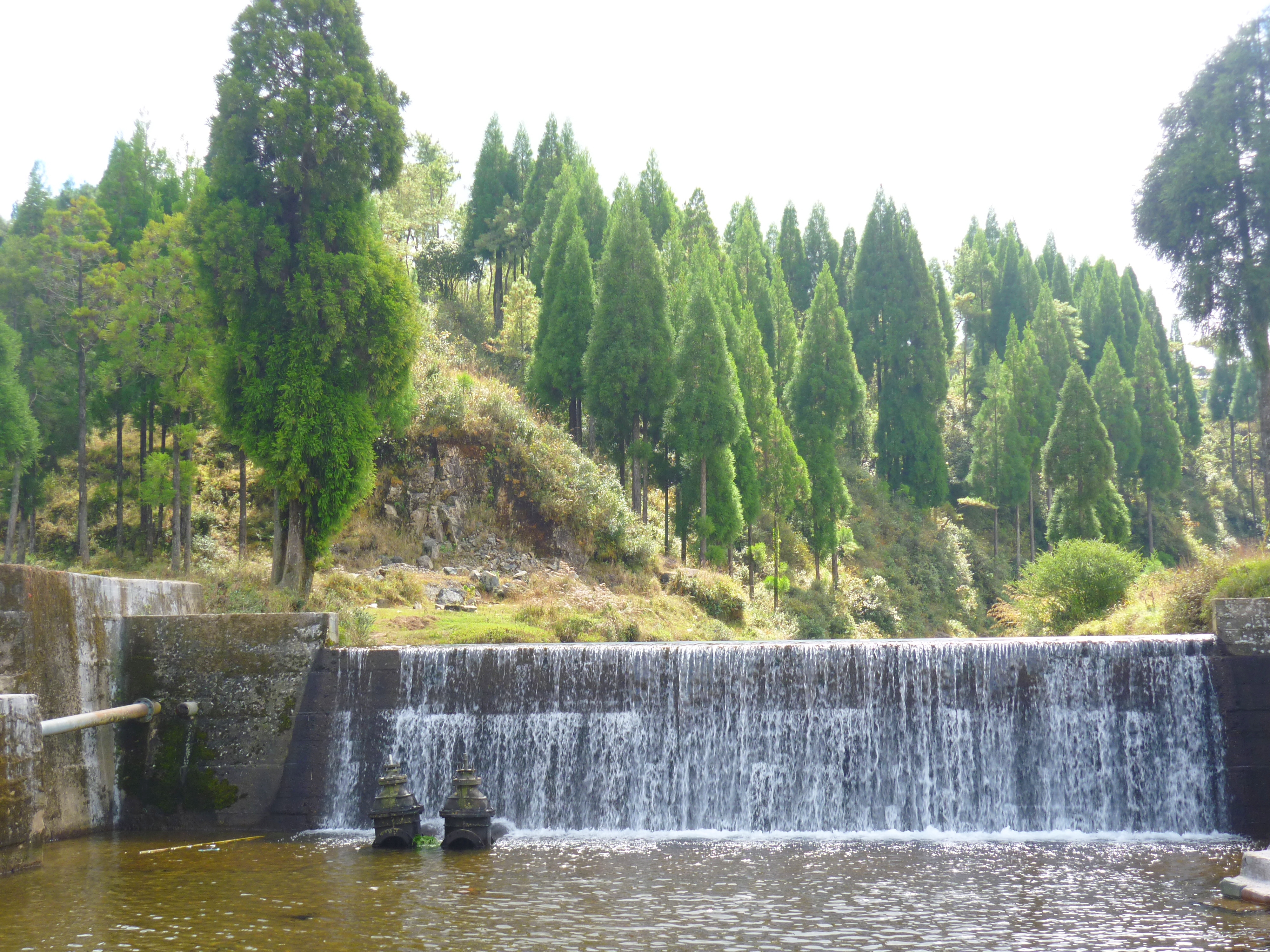
There are several attractions in Bhaderwah to mesmerise all genre of travellers who visit here during any time of the year. Bhaderwah is also called as ‘Nagon ki bhoomi’ (land of snakes) giving one a sense of its connection with mythology. Vasuki Nag is believed to be the keeper of Bhaderwah and hence the temple dedicated to this snake lord holds significance in the local culture. Thousands of pilgrims participate in the annual ‘Kailash Kund’ yatra that starts from the Vasuki Nag temple. The highlight of the temple is the idol of the presiding deity that is carved out of a black stone and is standing at an inclination. The temple is nestled within the narrow lanes of the town that snakes through ancient and traditional wooden houses from the time when the valley was ruled by the kings of Bhaderwah and Chamba. The town’s association with Mahabharata too can be felt at the ‘Gupt Ganga’ temple, on the banks of river Neru. The Pandavas are believed to have lived here during their exile. The Bhaderwah fort situated atop the town gives a good view of the entire region.
The Gupt Ganga river bank
The annual Tulip festival, Tilligarh rose garden and Gatha lake resort are some nice places for a day’s outing. Trekkers seeking to explore some breath-taking vistas can hike up the Jai Valley, Sonbain glacier, Kailash Kund, Peer ki pindi (camps of Akbar) or Seoj Dhar Meadow and connect with nature. If you are an adventure buff, the Jammu tourism has put in great efforts to cater to this segment with various outdoor activities like rafting in the Chenab river, rappelling, rock climbing, parasailing etc. Since Bhaderwah witnesses high snowfall, its high valleys are a great place for winter sports like skiing and snow-boarding too. It is slowly catching up as an alternate to Gulmarg in the state.
The Bhaderwah fort
Dirt roads and numerous water crossings in the region don’t fail to keep the adrenaline rushing for bikers who choose to ride here. The biking enthusiasts can opt the road through Padri, the highest motorable road in this region. Chattargala Pass is the highest motorable road and the most untouched point in Bhaderwah and offers a 360-degree spellbinding view of the entire region. It connects Bhaderwah with Basohli, another town of historical importance. One might be lucky to spot the endangered white vultures at this point or even some musk deer or Asian bears after a short hike up the hills.
One of the river and waterfall crossing on the way to Baderwah
The road to Basohli is picturesque with meadows, streams and typical pine trees all along the way. Sarthal valley is one of my favourite pit-stops along the way. With nothing much to do, it is beautiful with its laid-back scenery with Bakarwals (Shepherds) settlements amid green meadows and gushing streams from the glaciers. The seven-tiered waterfall located here is worth a short trek before riding up the treacherous road towards Basohli town. Basohli town itself is beautifully located on the backwaters of the Ranjit Sagar dam flanking it.
With political unrest being rampant in Kashmir, the main source of income through tourism has taken a huge toll in the state in the last couple of years. Jammu is very safe for all kinds of travellers and the tourism department is putting their best efforts to familiarize tourists with the other unexplored areas of the state. If visiting this state has long been on your bucket list and the unrest at the borders has kept you away, I think it is time you relook into your plan to visit the Mini Kashmir instead!
Fact file:
Getting there: Jammu is well connected by airport, rail and road. You can hire a self-drive car or a taxi from the city to visit the other sightseeing places. Bhaderwah is 280kms(about 5hrs) by road from Jammu city.
Stay: TRC (Tourist Reception Centre) guesthouses run by the J&K tourism dept., several homestays and budget hotels are available. Tilligarh tourist complex is a great place for one seeking luxury in nature.
Must try: Sip a cup of ‘Desi Chai’, a pink coloured tea that can be consumed either with salt or sugar.
Must buy: Basohli miniature paintings.
This visit to Bhaderwah was a part of our ‘Peace ride’, sponsored by Jammu tourism as a part of the Himalayan expedition to promote tourism in the lesser explored places of Jammu. The route we covered over the week was Jammu-Mansar-Basholi–Sarthal–Baderwah-Kishtwar-Gulabgarh-Sansari-Gulabgarh-Patnitop-Udhampur-Jammu. It has been over a year since this trip has been past and yet remains one of the best so far.
India has intrigued the world with its history, geography and culture- each individually dating back to several ages ago. I have been no different from the rest of the world. The LostLander has begun to embrace her landings after getting lost at random places in her incredible country. The more she is exploring her country, the more she has been discovering about its descendance and getting mind blown with new discoveries each time.
“The history of India’s physical geography is older than that of its civilization or even that of the human race. The subcontinent has been a distinct geological entity for millions of years. Therefore, to understand India, we must go back to the very beginning.”
-Sanjeev Sanyal
The fact that it is called as a subcontinent is associated to a larger theory of it being separated out of a supercontinent called ‘Rodinia’ and drifting apart from Africa, Antarctica and then Madagascar before it struck with the Asian continent. No, I’m not time traveling that far for now! It was just to put an exclamation to how amazing this country’s geography has evolved to be and what the natural bounty as we called it, has to offer in this beautiful country to an explorer… To take my article forward and with no biases, I divide the geography of this subcontinent into North and the South, just by drawing an imaginary line passing through its center, Seoni in Madhya Pradesh. Here is a humble attempt to take my readers through some of the beautiful destinations I have been to enjoy the natural marvels of Southern India. They are in random order and listed as and when I recollected them. For more details, you need to read my individual posts on them by clicking on their respective tags!
1. Kurusudai islands: Nestled off the coast of Rameswaram in the Gulf of Mannar, it is the only place in the world where the oldest and the last surviving living fossil is found in the world.
2. The table tops of Maharashtra: Be it the beautifully painted pink valleys of the Khas plateau, valleys of Matheran, Mahabaleshwar or any place thought of for a scenic drive for the Mumbaikars- have all formed out of large volcanic eruptions as the subcontinent merged with Asia. Not just that, these geographical features were strategically used by Shivaji to stop the invasion by the Mughals and hence called the Deccan traps.
3. Limestone caves of Andhra Pradesh: Belum caves, a part of a larger cave complex in the Erramalai region is the largest and longest cave system that is open to public. Similarly, the Borra caves is the deepest in the country. The speleothem formations are worth a visit which have formed due to continuous flowing of water over a thousand years, easily dating back to the Archaean age.
4. Gandikota: People call it as the ‘Grand Canyon of India. It is a beautiful gorge formed by the Pennar river as it squeezes from between the rock formation that has played witness to several kingdoms in history.
5. Eastern Ghats: Although I use a very generic term that specifies an entire region, they are older and mineral rich than their popular counterparts on the western side. All, again a resultant of several tectonic activities in the event of formation of the Indian mass.
6. Dhanushkodi: This abandoned town has more than just history of a cyclone. The revered ‘RamaSethu’ or the Adam’s bridge was formerly considered to be the largest Tombolo in the world and is believed to have formed due to the drifting of India and the Lankan land masses several thousand years ago..
Well… If all these have been the outcomes of several tectonic activities of the earth over a million years, there are yet several other amazing things that nature has to offer in the Southern peninsula.
7. Have you been to Wayanad in Northern Kerala? There is a heart shaped lake after a good climb up the Chembra peak in the western Ghats. It’s the nature’s way of telling ‘I Love You’!
8. Heard of the Barren island? It is the only active volcano in India, with the most recent eruption being in 2017. The sea area around it is considered to be one of the best dive sites in the world!
9. And then there is Baratang islands- It is the only mud volcano in India, situated in the Andaman group of islands.
10. Have you seen the Purple hills? Where do you think the Nilgiri hills in the western Ghats derive their name from? They’re so called because these green verdant hills are painted blue/purple (Neela in Hindi) by the Neelakurinji flowers, something that blooms only once in twelve years. The latest mass-blossoming being in 2018.
11. Cruised through the canals of Kuttanad? Mostly popular among the honeymooners and families alike for its backwaters and houseboats, what many don’t know about this region is that it is the only region in the world where paddy farming is done below sea level.
12. How about a boat ride in the Mangrove forests of the Bay of Bengal? The Sundarbans and Pichavaram forests are the first and the second largest mangrove marshlands in the world. A world heritage site that they are, an extremely important part of the ecology.
13. What happens when a meteor hits the earth? A massive crater is formed giving form to Lonar lake in Maharashtra. This Geo-heritage monument saline soda lake is the only high velocity impact crater lake on earth.
14. Seen the waterfalls of the Deccan plateau? Be it the Chitrakoot falls in Chhattisgarh, Gokak falls in Karnataka, Athirapally in Kerala or Hogeynakal in Tamil Nadu… They’re all so good they can give a good competition to the Niagara!
15. Heard of the Sentinelese tribesmen in the Andaman sea? They’ve long avoided contact with the outside world and their gene pool is believed to be one of the crucial links to early man and the evolution of mankind on the planet.
What India has to offer is abundant! And these are only a few places that I have been to in the southern India. Do you have any recommendations? Have I missed out on anything? I would LOVE to know… Please drop n your suggestions, recommendations, feedback in the comments section below 😊
I wasn’t sure if solo-traveling would be safe in Chhattisgarh, the campsite wasn’t ready yet for a Gujarat trip, Rajasthan had the election around the corner albeit having the perfect weather, the public transportation system wasn’t convenient in Arunachal, Uttarakhand had unpredictable weather of late, Jammu was done just last year, Dharamshala stretch would be too mainstream, Lakshadweep was too short a trip for the time I had. Maybe I should just settle down with the Sahyadris in Maharashtra or sign up for a fortnight long yoga session at Rishikesh or a Yakshagana course at Mangalore perhaps! I had tele-travelled almost the whole of India to decide where I wanted to go. And then, this happened! Just 4 days before departure, the mountains beckoned and I had finally decided to visit the Kinnaur valley in Himachal Pradesh.
Click here to read the complete story, on Amazon
Nothing was clear to me apart from the to & fro flights to Delhi. People around me were busy and my vacations couldn’t wait, lest they be lapsed without pay or without use. Although not very keen on solo travelling, I think that’s how life threw itself upon me when I longed to go to the mountains! The mountains have always been kind to me and have had me meeting them regularly over the last 4 years. I don’t know the reason for this special bond I share with the mountains. May be because I come from a nature worshipping community, that my connection with them is so instant and strong. The mountains had me amidst them yet again. From being a shy kid at ice breaking in public gatherings to having done a complete solo backpacking in an off-season, to meeting and hanging out with strangers and making new friends from travels, my journeys have brought me a long way! The mountains have been kind and have protected me all the way…
Given that I would be alone and I get muscle cramps when the temperature drops, the one thing I had to make sure while planning my trip was to not push myself too hard to see too many places or do anything that could drain me out. Hence, I decided to do it one place at a time, plan my next destination only after reaching a place and move only when I felt like I had sunk in well in the current place. So that said and Kinnaur had me there! After I had reached Himachal, there was absolutely no fear of being a solo-women traveller and no worries over safety concerns at any point of time. The people were amazing who derive their strength from their deep values… From being stopped by random locals on the road and being offered the juiciest apples from the valley to eating local food and getting invited to houses for coffees, from befriending the locals and then to being invited to attend a traditional Kinnauri wedding, from waiting for the day’s only public bus or hitch a ride to having stuck in a place for 3 days without any electricity or transportation due to snowfall, from meditating in the millennium old monastery to confronting a mummified Llama in the mountains, from driving past a valley of green-rock-and-sand onward to having returned through the same valley painted white in snow, from being seen-off by a close friend at the trip start to I seeing-off a stranger at the end of the trip: Whoa! What a journey it was!
So, the route taken by me was: Delhi- Kalka- Shimla- Sangla- Rakcham- Chitkul- Sangla- Reckong Peo- Kalpa- Nako- Geu- Tabo- Rampur- Sarahan- Shimla- Delhi. Some of the key destinations enroute and things I did were:
• The hustle of the desi music blasting at full volume had filled the atmosphere as the HPSRTC bus I boarded at Shimla cruised through thickets of sweet smelling Juniper and deodar. A solo snow laden peak emerged from amidst the green mountains. Call it layers of dew laden and mist covered hills, they sparkled as the sun’s early rays found their way forming several vibrant spectrums as the morning ride gave me the first glimpse of a horizon that had a never-ending line of snow-capped mountains.
• When the bus alighted at Sangla after making its way through steep gradient, blind corners and breath-takingly scary heights of the snaking roads, the sun was calling it a day. It had cast a golden red glow to the entire range of Kinnaur Kailash mountains. I couldn’t have asked for more as I stood there to be welcomed by this magnificent view right in front of the bus stand. The hike up the Kamru fort to catch the golden peaks up close was a cherry on the icing.
• The next day was an exhilarating bus ride through the Sangla valley, overlooked by the Kailash mountains on one side and the beloved untamed Baspa river flowing below. The ride was adventurous with waterfall and river crossing, cliff-hangers, landslides and occasional sightings of mountain goats or yaks. Quick stop-over at Batseri village painted in shades of crimson, chrome to ochre with the trees of apples, apricots and walnuts was a feast to the eyes. A walk down to the river at Rackcham helped me to connect with the Kinnauris with very warm conversations. They offered me a ride through apple orchards and buck wheat farms before meeting the sole Indian tricolour waving at Chitkul, a village bordering China & Tibet.
• The following morning, I started early to Kalpa- a quaint tiny village with old traditional houses amid the Kinnaur apple farms. A solo hike through the suicidal roads to Roughi village turned out to be special when a random dog decided to accompany me all the way. Again, the setting crimson sun cast its magical spell over the manifestations of Shiva and Parvathi seated conveniently in the Kinnaur Kailash mountains overlooking the village. With the chants from the Buddhist monastery next door and swaying prayer flags as I looked out of my window the next morning, I couldn’t have asked for a better start for my day.
• That day, I did a bit of shopping and grooving to traditional Kinnauri music with the locals at Reckong Peo, the ‘Gateway to Kinnaur valley’. It was the annual fair where people from all over the state had congregated to buy and sell local Agri-products and handicrafts apart from sipping the local apple brew. Packets of pine-nuts, dried apples and apricots along with the traditional Kinnauri hats were perfect souvenirs to take back before boarding the bus to my next destination.
• Although the weather had gotten more colder, it was one of the finest mornings so far. A walk around the village of Nako, with mud-smeared walls of houses built of wood and clay is one of the highlights of my entire trip. While strolling through those narrow walkways of the village, I felt as if I was exploring a maze. With the early morning vibes of a typical village with cattle roaming around, children walking down to schools, chants and incense from the ancient monastery rising in the dew laden air, it was an altogether different world there. The view of the distant snow-capped mountains and the barren winding landscape around had me spellbound for the rest of the day.
• I woke up in the biting cold next morning to hike up the hill and pay a visit to the mummy of a Buddhist monk, believed to be over a 500yrs old. Strangely, it has been there in open atmosphere without any chemicals and among the only few mummies available in India. Quick breakfast at the wedding house and I was good to head out by hitching another ride until Hurling.
• The weather had gotten worse that day with a forecast of precipitation by day end. As I waited at Hurling for my next ride, the guy making rotis at a hotel offered me a cup of free chai and got me a free drive with his customer to my next destination. With a loaded car and a person with a broken leg hanging out of the rear seat, the people who agreed to drop me were more than sweet to accommodate me in the front seat and they carry my backpack on their lap all the way in the rear seat.
• The morning when I woke up, the mountains had moved closer to me with a heavy overnight snowfall. This was a sight to which the heart of a snow-deprived-south-Indian-city girl in me had skipped a beat. I had to extend my stay at this monastery due to heavy snowfall for next 2 days and with no electricity, phone connectivity and no plumbing that worked whatsoever, it was ‘THE” time! Amid all this, I had the rare opportunity to relish the Tabo apples (one of the best in the world) every day of what was being offered to the deity at the monastery.
• Finally, after getting my drive back to Shimla- I had plans to stop by at Rampur Bussahr to see the erstwhile palace and stay at Sarahan, one of the Shakthi peethas in the foothills of the Himalayas. But, the mountains had an altogether different itinerary for me for the last 3 days! So, thus was my sojourn in the Himalayas, the mighty incredible Himalayas!
Since Rohtang pass had closed by end of monsoon, I did only Kinnaur and half Spiti and returned the same way back (Although a little hectic with 3 days required only for travel, on the same route). If you are traveling in the summers, then you can start from Shimla and complete Spiti & Lahaul via Kaza and exit from Manali, thereby not repeating your route.
Summary: With the changing landscape throwing surprises at the wink of an eye, each mile was magic. The valleys were overwhelmingly beautiful! When the mountains beckon, just pack your junk and head out! The destination doesn’t count, the journey is worthwhile!
Being abundantly blessed with natural beauty, Anshi National park and Dandeli Tiger reserve is one of the first hotspots of the elusive black panthers in India. Apart from its paper mills, Dandeli is also known as the ‘Rishikesh of the South’ for its river rafting in the waters of River Kali. As if these weren’t reasons enough for me to backpack, I got invited to stay at the ‘Dandeli Jungle Camp’. What better way to reconnect the lost bond with nature than camping in the woods? I jumped to grab-in when opportunity struck! This was a Solo trip that was long due, and I had alighted for sunrise at the Dandeli bus stand on a Saturday morning.
Itinerary: Friday: Overnight journey from Bangalore Saturday: Alight at Dandeli town, Drive to ‘Dandeli Jungle Camp’, Visit backwaters of Supa dam, Shop for some forest produces at the tribal shop, Visit Syntheri rocks, sunset hike at the homestay Sunday: Birdwatching at timber depot, river rafting & coracle ride, (Visit Kavala caves or the Siddi tribal village if you have more time), Leave for Bangalore by evening (direct bus from Dandeli or by train from Hubli)
Details:
After a 30mins drive through the forests to Pradhani, a further off-roading of 2kms from the main road lead me to this simple homestay and camp run in the lap of nature amid the woods. The eerie silence of the elusive woods and the stridulations of the crickets instantly calmed my soul by responding to the deep calls of nature. A basic cottage with all the essential and neat amenities was awaiting me in the midst of the jungle overlooking a farm of areca and mangoes. I couldn’t ask for a better place to be, to feed the wanderlust and nomad in me for the weekend. I was excited to be greeted by Malabar giant squirrels and sambar deer at my doorstep to say the least. One can also avail their tenting facilities with bon-fire if it’s a bunch of friends traveling together. Mr. Dharmesh, the ever smiling owner of the property says that the camp was started by a French lady 3 decades ago from whom he has taken over so that he could settle down in the woods after he quit his well-paying job at one of the top-star hotels in Bangalore. He had planned a detailed itinerary for me, and I can’t thank him enough for his warm hospitality. After dumping my luggage and a nice lunch, I set out for some exploration.
View from the Supa dam backwaters
A stroll along the dwindling lonely road on the backwaters of Supa dam offered a panoramic view of the distant hills, only if there was good rainfall- it would have been a gorgeous sight. After a quick stop-over at the tribal shop to relish a glass of kokum juice and buy some jackfruit chips and papads to take back home, I was taken to Syntheri rocks. This is a very beautiful little place located deep in the woods and formed by rich mineral ores that have formed beautiful rock patterns by standing the test of time. A drive to the Kavala caves, A coracle ride in the ferocious rapids of the Kali river, a dip in the natural Jacuzzi, crocodile walk is some of the other activities included in the package that kept me busy through the day. An evening walk in the woods around the property with a personal guide was a memorable time spent identifying the calls of various birds and inhabitants of the forest. The large number of hornbills that fly into their nests in this forest with a small hike into the jungle at sunset or catching the sunrise from my window are only some of the fancy things that my stay offered to me.
Syntheri rocks, Photo by: Gowtham Shastry
The next day, Mr.Dharmesh personally dropped me off for the early morning bird watching walk that was arranged at the Dandeli timber depot. This first time experience of birding is something that I will cherish for a long time and is written about as a separate post. A bird watching tour around the depot where over 150 bird species could be spotted on any given day- was the highlight of my trip to Dandeli!
So, the next big agenda was meeting the Siddhis- The tribal community endemic to the Kali reserve region who are believed to be of the African origin. Be it chilling with them over some rustic music or trying their favourite delicacy- the red ant/ termite chutney, the experience is sure to leave one amused and feel time travelled.
A coracle ride in the Kali River, Photo by: Gowtham Shastry
With so many activities included in the package that kept me on toes through the 2 days I stayed at this property, it is a high recommendation from me. If you wish to extend your stay by another day, you have no dearth of things to do- from river rafting, to a canopy walk and visit to Dudhsagar falls, all can be arranged by the camp guys themselves. After freshening up at the camp, I started my journey back to Bangalore. I took a KSRTC bus from Dandeli to Hubli from where I had booked my train. Whoa! Such a wonderful trip!
‘Dandeli Jungle Camp’ is an offbeat stay which does not have its own webpage or have direction boards to keep commercialization at check. From the time I alighted at the bus stand till the time I boarded for return, my entire trip was managed by www.dandeli.com through whom my package was booked. The connectivity of public transport within the reserve area is scarce and being a solo traveler, all my travel hassles were taken care by these wonderful organizers.
It is needless to elaborate on the names Tirumala and Tirupathi! Famous as the richest temple in the world, the seat of Swamy Venkateshwara- the lord of seven hills. What goes beyond just this RICH temple is its geographical location. For someone who has been there and used the 11km long stairs to get to the top, I’m sure he must have enjoyed the multiple pit stops and deviations off the course to see the ‘Papavinasanam’ and ‘Akasha Ganga’ waterfalls enroute. And then there is the magnificent Silathoranam, the natural arch bridge formed due to volcanic erosions several million years ago… As if these pit stops weren’t enough, one is bound to get enchanted by the stunning view of the entire range of hills surrounding the temple with the Nagari quartzite formations… Ever since I had been there, exploring these hills has always been on my bucket-list… And when I chanced upon an opportunity to do it over a weekend, I jumped in with excitement. Taking cue from a random couch-surfing meet-up, we had decided to hit the roads to explore the hill ranges of Eastern Ghats. So on a Saturday morning, we started from Bangalore before sunrise to see the highest waterfall in the state of Andhra Pradesh, nestled in the Venkateshwara National Park. While I slept for most of the way, I was awakened to a blurred view of a fiery-red sunrise seen through the dew-laden window glass of our car, cruising through misty roads with hazy paddy fields around. We stopped by at one of the several restaurants on the way for a nice south-Indian breakfast and coffee.
With good asphalted road all the way, we arrived at the forest check-post at Talakona. While our friend was getting the required permits / entry tickets into the national park, we got chatting with a fruit vendor who let us try the variety of fruits in his cane basket which all tasted as sweet as nectar. He then told us that he could be our guide (at a small cost) and show us some offbeat corners of the forest. We agreed upon the idea and promised to buy more fruits from him on our return to make up for his business. We then reached the eco-lodge, managed by the forest department and ordered for food which would be kept ready by the time we returned from our trek from the woods. We then drove up, till the Siddeshwara Swamy temple and parked our vehicle near the foothills of the waterfalls. Our guide took us off the course from there on through stone-laid stairs that seemed like we were walking into oblivion in the jungle that is notoriously famous for red-sandalwood smugglers and the elusive beasts- the Royal Bengal tigers. Our first stop was at this view point from where most of the green and brown stretch of alternating forest and quartzite was seen. After a short climb thereon, our guide made us cross a stream of water and took us to the edge of the rocky path. The stream now seemed like it was jumping down in a mad rush from the cliff we were standing upon, and we could hear the screaming of several tourists down beneath. That’s when our guide burst the bubble for us- We were standing right on top of the highest waterfall of the state. It was a nerve wracking experience to stand atop there and watch the water gush down under our feet and have a post-monsoon gorgeous view of the green ranges.
The view of the ranges atop the waterfall
We were then guided through a canopy of lush green trees and hanging branches along the flowing water, at the end of where our feet stopped! Stopped in amusement… Amusement at what our eyes were seeing… A thick moss laden semi-circular rocky wall due to the flowing water over ages across whom several creepers hung and the water dropped down with all grace. This entire set-up of nature reflected in the mirror-like crystal clear water of the pond formed beneath where the golden fishes were enjoying their undisturbed swim. The rocks inside the pool made it appear rather shallow and was enticing us for a quick swim! With absolutely nobody else in the place- No exaggeration, it felt like we had found our long lost connection with nature right there! All unprepared for a swim, we put our legs into the freezing cold water to get a nice fish pedicure that de-stressed the city souls in us!
The pool atop the Talakona waterfall
After getting our natural fish pedicure done, we headed back towards the base of the Talakona waterfall. But, it was a different route this time… It was a beautiful path with a canopy of trees, a deep gorge to our left and the massive rocky caves to our right accompanied by an eerie silence of the jungle… At the end was another waterfall. It was one of the levels of this multi-tiered waterfall which we had to cross through. For a look from the distance, we could not gauge the level of difficulty until we actually got on the rocky path to cross it. While each one of us mocked and took fun in laughing at why the other person couldn’t cross it with ease, we dreaded our own feat of the waterfall-crossing when we slipped, slid and even glided across the super slippery rock over which the algae had settled making it an armed to the teeth adventure. We had a friend who slid and landed right at the edge of the cliff, just an inch further would have taken him rolling down the multiple tiers of the highest waterfall of the state 😛 All said and done, with we being drenched to our bones, our jaws chattering with cold and an unexplainable feeling of accomplishment, we had reached the last part of our hike.
The path across the caves
We then walked down to get a good look of the mighty Talakona waterfall from its base right-up, to understand where we had just arrived from… We then drove to the eco-lodge to dry ourselves, get some food and to call it a wrap for an eventful day that we concluded at twilight!
I could not express better than these lines picked up from a website, “If the Raindrops elevate your mood, clouds stir your senses and rainbow brings out childlike pleasure in you, then don’t hold yourself back. We are taking you to the abode of clouds-Meghalaya; where rain weaves a magical spell, spellbinding beauty haunts your senses and you witness nature at its best. Witness the monsoon magic, majestic waterfalls, live root bridges and more…” and one can go to no better place than Sohra fondly called Cherrapunjee to experience all of that Meghalaya has to offer in a small place.
This post is part of my fortnight long road trip across North-east India, specifically covering parts of Meghalaya – Assam – Arunachal Pradesh I had tagged along with two other travelers and drove around the state of Meghalaya in a self-drive car hired at Shillong. The places visited in Meghalaya include Shillong – Smit – Cherrapunjee – Mawlynnong – Dawki – Ribhoi- Shillong.
Our Itinerary:
Day 1: Arrive from Shillong / Smit; Wahkabah waterfall, Arwah or Lumshynna caves, Nohkalikai waterfalls, seven sister / Nongsthiang falls (Night’s stay at a local homestay) Day 2: Tyrna village, Nongriat trek (Double decker rootbridge & Rainbow falls), Mawsmai cave/Krem Phyllut, Ummunoi root bridge at Laitkynsew village (Night camping at Nohkalikai) Day 3: Dianthlen waterfall trek, Sohra market, Ramakrishna mission, Mawkdok valley, Thangkharang park, Moktrop rock; journey towards Mawlynnong.
The Details:
Like most tourists, we started our day early from Shillong via Smit. To differ from the rest, we had a self-drive car at our disposal so that we had the liberty to stop whenever and wherever we wanted. The drive route was mostly untouched and its rustic charm kept us excited all through as this route is less treaden by the tourists. Pine plantations, lesser explored waterfalls nestled away from the main road, well groomed vegetable farms, hay shacks were a common thing for us while we had stopped atleast 100 times for photos.
A reservoir enroute to Cherrapunjee
As we approached Sohra, we stopped at several view points, Wahkabah waterfall being one among them. India’s longest cave and the most numbers of limestone caves in one place happens to be in Meghalaya and hence Meghalaya is a haven for cave explorers. Our first stop at Sohra was at the Arwah or Lumshynna caves. Relatively smaller compared to the other caves in the viscinity, but is tucked away in a gorgeous location overlooking the deep valley with the Nongsthiang waterfalls.
After a brief visit, we headed towards our next stop: Plunging down from a height of over 1100 feet, Nohkalikai is the highest waterfall in India. We trekked down the steps and a little beyond into the bushes and enjoyed the rare views of the waterfall away from the reaches of normal tourist. There is an option to camp at the Eco park, over the seven sister / Nongsthiang falls. But we decided against it as the place is filled with backpackers and would’ve been too clumsy for us, we were someone who wanted a peaceful place away from the crowd.
The Nohkalikai falls
Pitching a tent in Sohra requires prior permission from 4 different authorities: the land owner, the Siam of the village, the local government body and the police. In search of a nice place to pitch our tents, we took help of one of a local Khasi friend. With the local connect, our quest to find a piece of land to pitch a tent ended up more like an exploration of Sohra. We could go to some of the untouched places and sunset views that was completely out-of-reach from typical travellers. We were taken to remote places like banks of a small river, a cliff off-a-small hillock, plains overlooking massive gorges, cement factory backyards among other places. With the sun-going down early in this part of the world, we had very little time in hand and insufficient preparation for the night’s camping.
We finally ended up staying with a Khasi family in a local homestay located amid a serene location. The stay however was the highlight of our day: the warm hospitality of the Khasis is something that will never let one regret their choice of stay. Our host at the homestay, accompanied us for dinner and for a drink as we got discussing everything from Khasi culture, ceremonies, politics, sports, tourism et all under the sky, a clear night’s sky. With no pollution in the atmosphere, my friend helped me to identify several constellations from the place that was brilliant for star gazing. It was an unforgettable night for us with the Khasi family.
The village settlements around our homestay
Next day, we drove to places around Cherrapunjee including the villages of Tyrna, Nongriat, Mawsmai cave/Krem Phyllut, Laitsynkew to explore the living root bridges which was an activity from dawn to dusk! We got in touch with a local guide ‘Mr.Paradise’, who then arranged for our camping in the Nohkalikai village for the night. It was yet another wonderful night spent with new Khasi friends, as we enjoyed Khasi music, the enriching conversation with Paradise and his friends about the Khasi culture. We gained insights about their customs, religious practices, respect for people, nature’s love among many other things. It was a long night under the starry sky with only my friends, Paradise’s friends, myself and the campfire! Suddenly, while the last bit of the firewood was being lit and just before the night broke into dawn, the skies of Meghalaya had shown their power. It poured cats and dogs for the rest of the night, with thunder storm and lightning. We sheltered ourselves inside our tents while I continued to shiver with cold.
At dawn’s break on the following morning, the skies had seemed to have mellowed down and we stepped out of our tents only to be awed by the beautiful sun rising over India’s highest waterfall! Yeah, Meghalaya has been wonderful to us all this while and this was another new day in this ‘land of clouds’. While we had planned a short trek across the Dianthlen falls, the rain gods continued to lash throughout the day. Cherrapunjee is the wettest part of the world. So, what’s the whole point if one doesn’t experience the rains here, right? We walked in the places around Dianthlen falls and enjoyed the rains for some wild fun but getting drenched till our bones.
One of the suspension bridges on the way to Dianthlen falls
It was already noon and we couldn’t cover the other few places as planned in Cherrapunjee because of the poor visibility due to heavy rains. Anyway, speculating no possibilities for any improvement in the weather conditions, we decided to drive to our next destination- the Jaintia hills district.
The rain fed roads of Cherrapunjee
While the warmth of the very hospitable Khasis has still left me in awe and amusement, I’d like to end this note here with these lines:
“Even then, goodbye dear Cherra, and your rain goodbye. For my life is yonder, though my love is here.”
As kids, we always imagined fairies with wings flying amidst colourful gardens, rope like creepers hanging across the forest thickets, rainbows emerging on the tranquil sky. Do you agree when I say this is how most of the animated movies depict fairy tales ? Nestled deep in the rich forests of Meghalaya; with NO exaggeration, that’s how I would describe this village called Nongriat!
This post is part of my fortnight long road trip across North-east India, specifically covering parts of Meghalaya – Assam – Arunachal Pradesh I had tagged along with two other travelers and drove around the state of Meghalaya visiting Shillong – Smit – Cherrapunjee – Mawlynnong – Dawki – Ribhoi- Shillong.
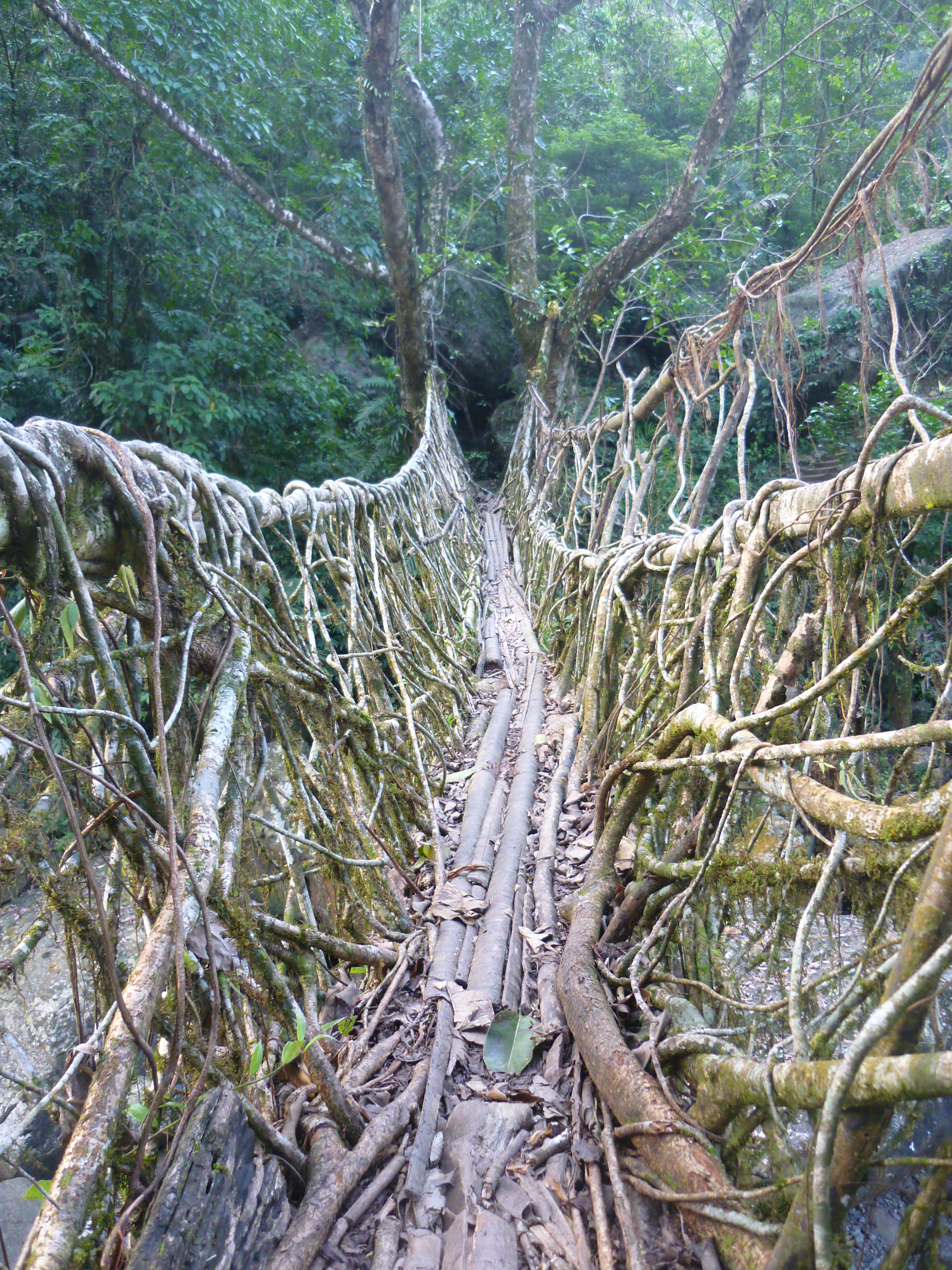
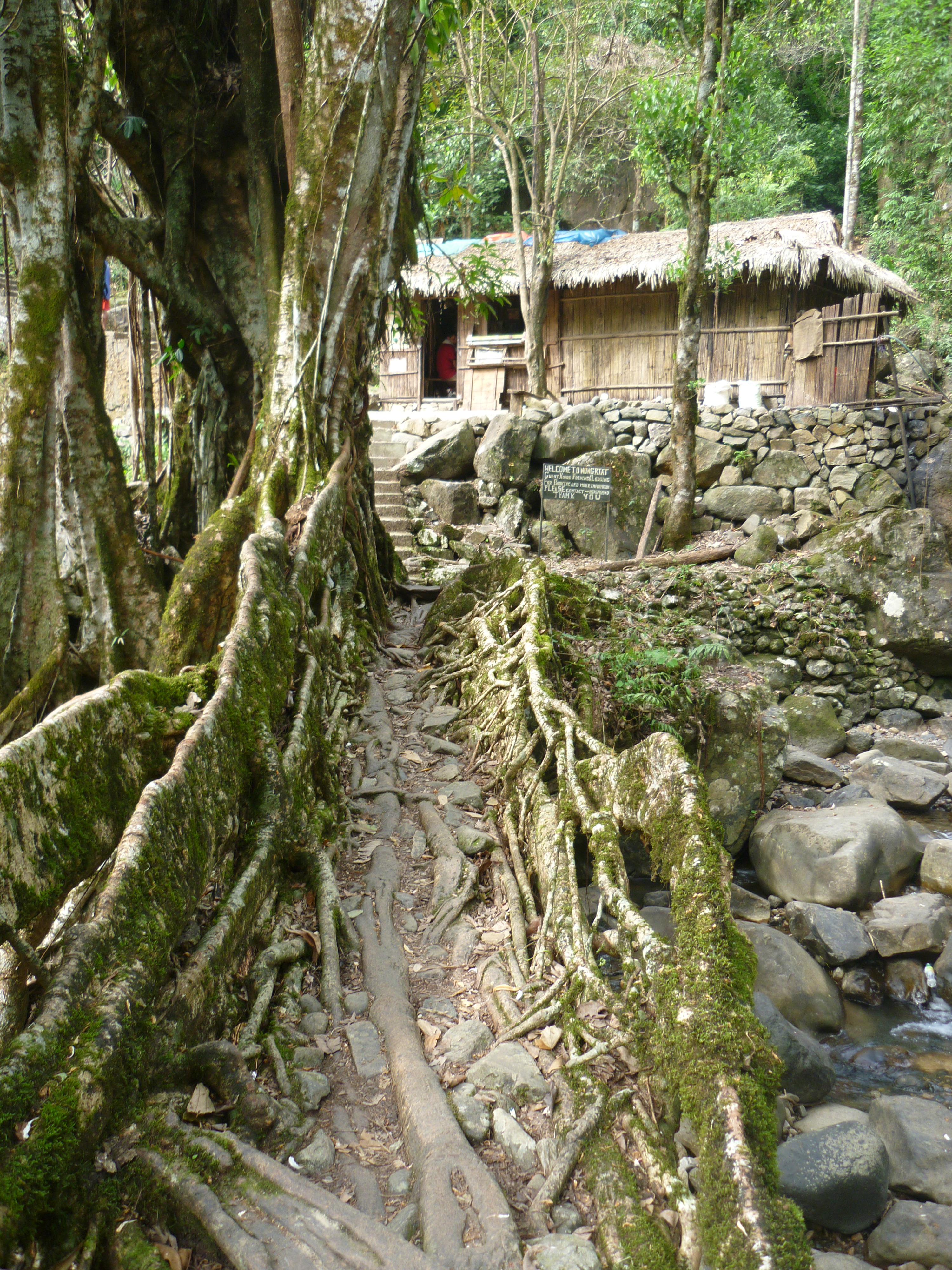
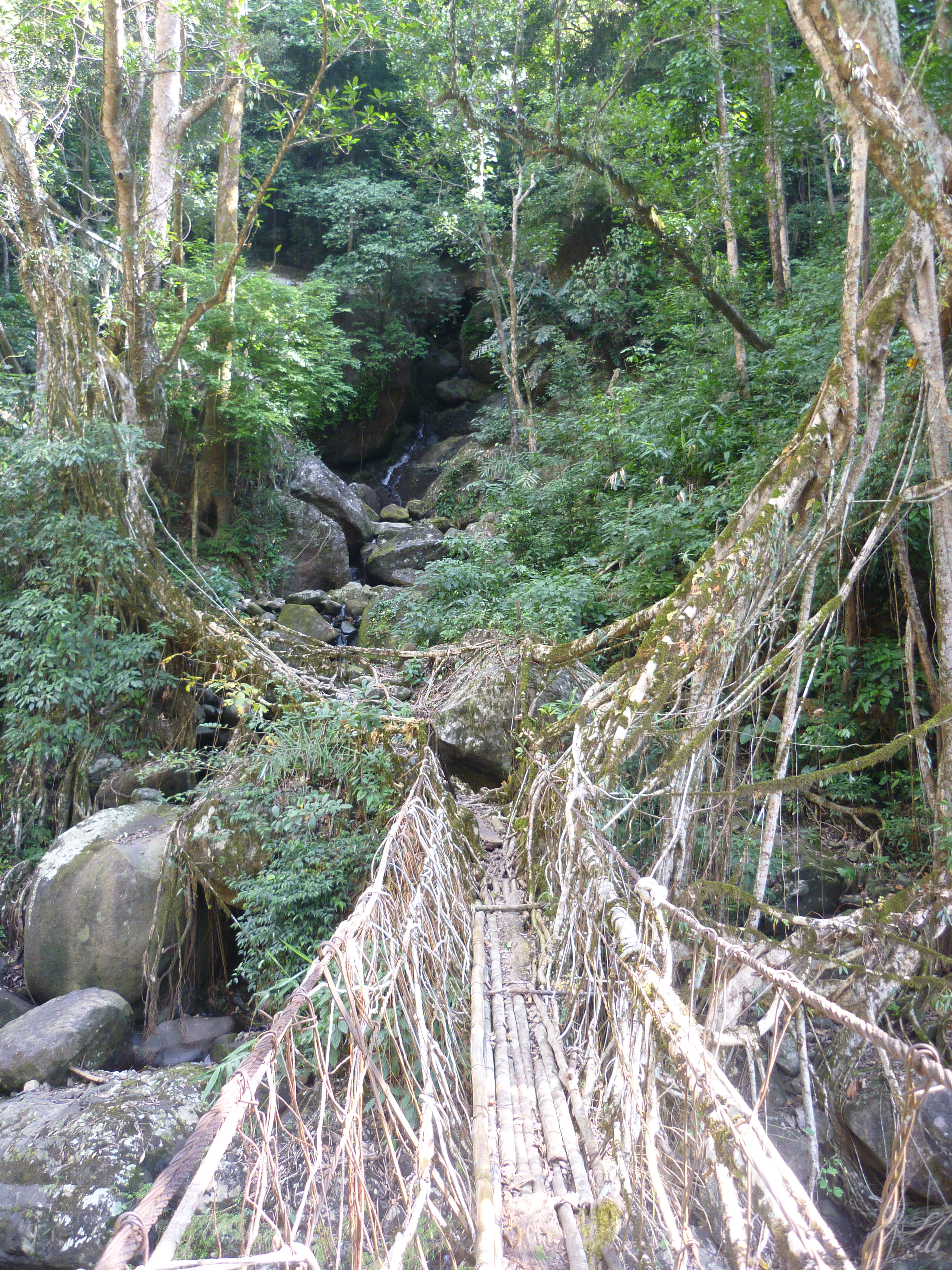
A pleasant drive through the breathtakingly beautiful valleys and naturally formed creepy high limestone walls brought us to a village called Tyrna in Cherrapunjee. That’s where the tarmac ends and our car had to be parked. Further, we trekked down to the Nongriat village: where the ‘Umshiang bridge’ or popularly called ‘the double decker root bridge’ exists. One needs to climb over 2500 steps each way, so that this piece of marvel can be seen at close quarters. Root bridges are created by inter-weaving the roots of the rubber tree by the tribal folks who live in the deep forests of Meghalaya for their local commute across the bloated rivers during monsoon. A bridge fit for usage can take a minimum of a couple of decades and it only gets stronger with age. There are several such living root bridges across Meghalaya and most of them continue to be untouched by the tourists due to their remoteness. We were here, to tread on some of the most popular living root-bridges of Meghalaya.
The route to Tyrna village
Although, there is a well laid out path of stairs all the way, we thought it was wiser to have a localite who would enrich us with the facts and figures that we wouldn’t get to learn otherwise. At Tyrna, we met a Khasi villager from Nongriat who agreed upon to guide us through our trek. We passed through several sacred groves and areca farms belonging to the villagers. After decending about 1000 steps, a small deviation to the right indicated the way to Nongthymmai village. We took this deviation to reach the ‘Ritymmen root bridge’ a single bridge and another old one next to it which has taken its toll due to the negligence by the localites. Our hearts were jumping with joy at the first experience of treading on a living root bridge, that we had only read about until then… I decided to throw my shoes away for a while and enjoy the feeling of walking barefoot on the bridge.
The Rythimmen bridge at Nongthymmai village
After spending some time, we decided to continue the trek and our new friend cum guide, continued to enlighten us about the rich traditions and culture of the Khasis. We stopped by for a quick breakfast at a straw hut selling 2-minute noodles and lemon tea. Further, a short climb of stairs continued only to be awestruck by the marvel of indigenous engineering: The double decker root bridge, the main motivation for us to trek this far. It was like fantasy out of a fairytale: creepers hanging across a little waterfall, fed by a pristine river in the middle of nowhere! It was tempting to get our feet wet as we watched a few tourists who had stayed in the Khasi homes around the root-bridge over the previous night and enjoying their swim in the cold waters. However, spending some time admiring this piece of absolute marvel, we decided to move ahead, towards our next mission: Rainbow falls!
Entry bridge to Nongriat village
Nature’s best kept secrets are those which are untouched due to their remoteness. Rainbow waterfalls being one of those. The small number of tourists who make it till the double decker bridge seemed to have had disappeared there onwards. The tiring path ahead was going to be tiring, we were told. But, nothing comes easy.
I was doing this trip post monsoon (October to be precise) and that’s when the caterpillar larvae take wings! Like winged fairies, we were greeted and accompanied by butterflies of all colours, shapes and sizes all along the stretch from Umshiang bridge (the local name for the double-decker bridge) till the rainbow falls. We had to be extremely cautious while walking, clear the way for ourselves with a stick, lest accidentally step on these little winged beauties. The path was so full of butterflies, that it cannot be expressed with words and the joy can only be experienced. Truly, in every sense: I was Alice, walking in wonderland!
Another root bridge enroute to Rainbow falls
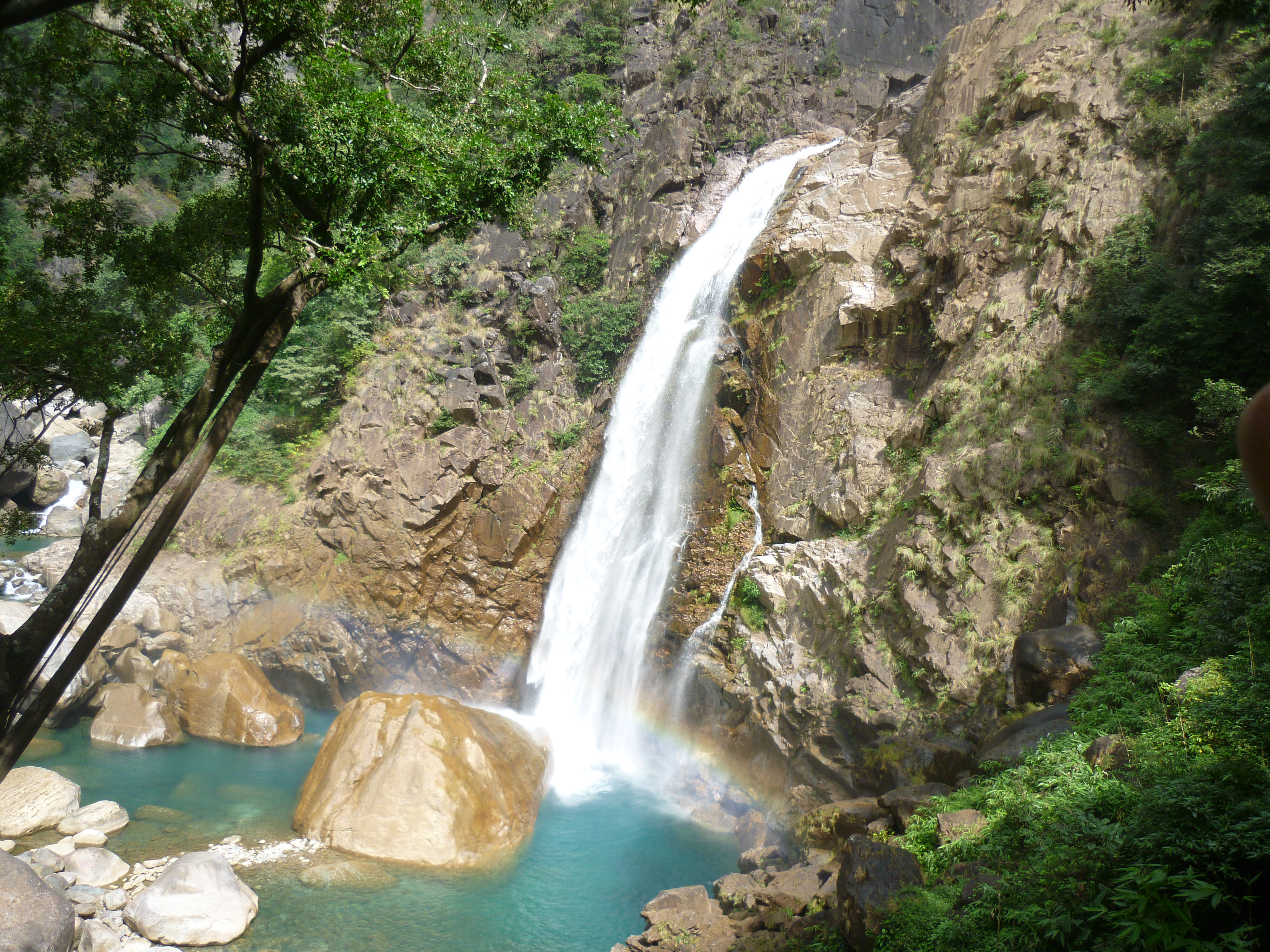
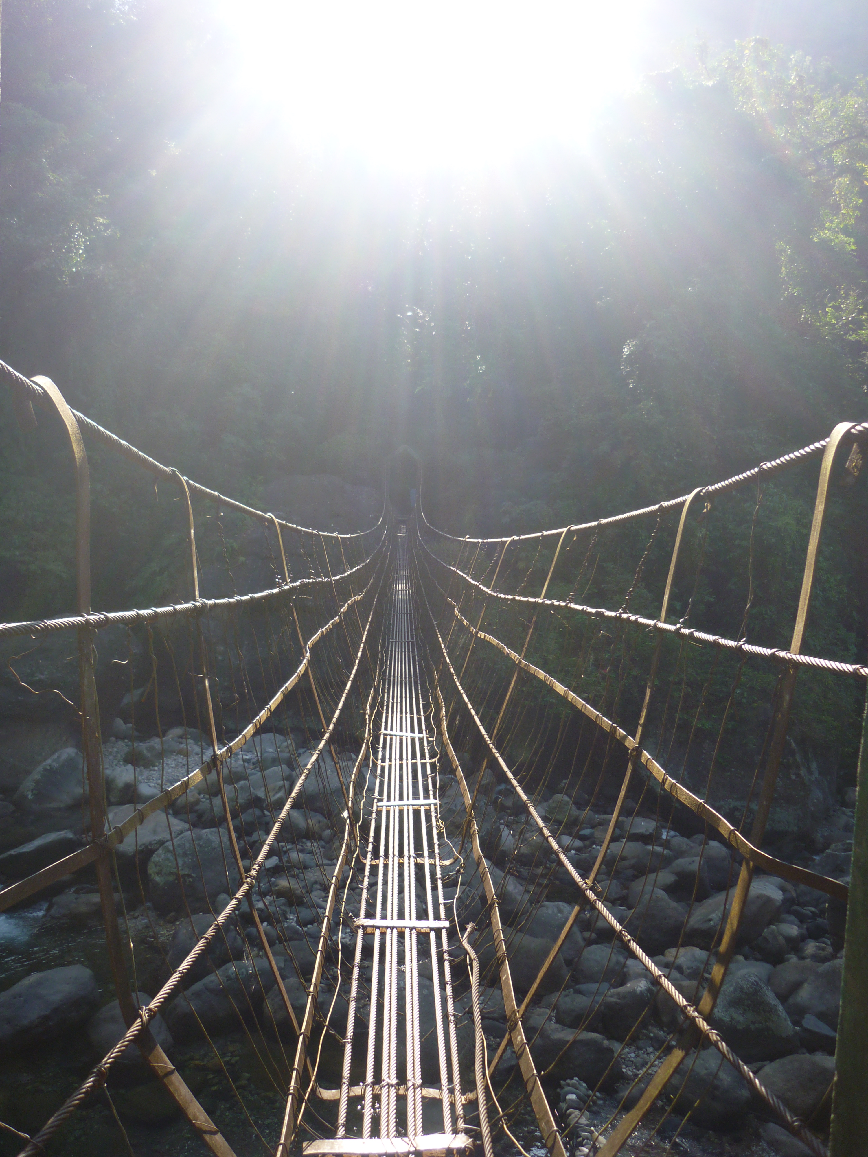
It was a walk of nearly 2hours through the thickets of the sacred forests and crossing at least 5 other root bridges and a couple of metal rope bridges that were laid across the deep river that flowed down with its seductive clear blue waters. After the brisk climb, we had finally arrived at the place where a hidden jewel of nature unfolded itself, from amid the greens…
We stood there in AWE….. the green trees and bushes had opened up to display a canvas with milky white waters gracefully tumbling down into a pool of turquoise blue and a hundred fairies flying around us. A dozen spectrums added to this heavenly scenery! On a clear sunny day, there could be 50-100 spectrums around the waterfall, giving the place its name: Rainbow falls! We enjoyed a couple of hours in calm just by sitting beside the naturally formed swimming pool as we were the only people in this fairyland and restoring our lost bond with nature that was shared long ago.
The Rainbow falls
As described by our guide, camping at the Mawsmai caves (2hours trek further) and climbing up the hill to be greeted by the Nohkalikai waterfalls, the highest waterfall in India would have been a complete story! Unfortunately, we hadn’t known much about the enchanting beauty of this trek before embarking on it and had no preparations now, to have it extended further. So now, it was well past afternoon and distance that required to be walked back was long. The sun sets early in this part of India and that meant that we had very less time of daylight left. During our return, we stopped by at another hut near the Umshiang bridge for a late lunch where we relished a simple Khasi meal of rice and bitter lime curry.
A metal rope bridge near Rainbow falls
The walk back from there onwards was taxing and it is a very steep climb up the 2500 odd stairs.. I stopped several times at the little homes and stalls put up by the villagers on the way to keep myself hydrated with the local energy drinks and fruit juices. I cannot forget the way our guide cum friend Denzil kept motivating me to complete the stretch. He kept reducing the count of steps by hundreds so that I would climb faster with the intention of reaching the top ASAP. Finally, I was back at Tyrna, even while there was sufficient sunlight for us to drive back to Cherrapunjee.
A small deviation from Tyrna will lead one to ‘Ummunoi root bridge’ in the Laitkynsew village, one of the oldest bridges in the viscinity. It has been truly a very refreshing way to explore ‘the abode of the clouds- Meghalaya’.
Conclusion remarks:
For all trekking enthusiasts, a two day trek covering Laitkynsew, Nongriat, Mawsmai and Nohkalikai is highly recommended.
This post is part of my fortnight long road trip across North-east India, specifically covering parts of Meghalaya – Assam – Arunachal Pradesh I had planned to visit Shillong – Smit – Cherrapunjee – Mawlynnong – Dawki – Ribhoi- Shillong during my weeklong stay in Meghalaya.
I had decided to explore some places all by myself and Smit happens to be one of them. After seeing some spellbinding photos on the internet, I wanted to visit the Laitlum valley as well. Although there are public buses from Shillong to Smit, the connectivity further to Laitlum isn’t great. This is where one needs to have a travel arrangemtn of their own, or in my case: to hitch a ride to reach Laitlum. Since it was my first day in the state, I did not want to get too adventurous for being alone. That’s why, I hired a taxi from Police bazaar (in Shillong) to Laitlum.
This drive was very refreshing for me, whose mind was cluttered by all the madness of traffic, pollution and work tension back in the metropolis (Bengaluru). I was requesting my driver to stop the car after every other kilometer to capture the seducing beauty of the place with my not-so-good camera. The bamboo trees and terrace lands with potato farms, all added charm to the landscape that was very beautiful even otherwise. To add to the pleasure of the drive, I was having a good conversation with the driver as well. Althiugh I had hired a personal taxi, I did not mind to let a few locals into the car when the driver asked me if I could allow them. Given the remoteness of places and the scarce connectivity through transposration, I had absolutely no problem with offering a ride. The next thing I experienced was that there were atleast 50 passengers hopping on and off at every stretch for their ride. And would you know what was exciting for me? All locals who boarded the car used to get overly excited about meeting a foreigner (Yeah… That’s what they called me!).
Smit is an old rustic town and the cultural centre of the East Khasi hills, but there isn’t much in this town apart from the Siam’s house. A road flanked with well groomed pine trees lead to the Khasi Raja’s palace. The Raja or the head of the clan is called ‘Siam’ and he lives in the same premises. However, the wooden palace is used only on special occasions when there will be large tribal congregations, like the Nongkrem festival for example. This typical Khasi styled wooden house is said to have been constructed with zero iron nails and only wood for all joints. Although I met the Siam, he did not seem to be a photo friendly person when I asked for permission to photograph his little children.
The Siam’s house at Smit
We then drove to Laitlum valley, located at about 5kms ahead of Smit. It was an offbeat drive through the rarest stretches of countryside. We passed by a lot of school kids who were on their way to school. Few were happy waving at me while a few were busy pranking at their pals as they walked. Having been born and raised in a small town myself, it was a flashback of typical childhood days in a rural setup. There were a couple of school teachers in my backseat, chatting happily with me and patiently waiting in the car while I would get down to take photos. Overall, it was a very pleasant drive until we reached the Laitlum gate. While the driver wanted to sit back in the car, he asked me to enjoy the view and return.
I was the only person amid the green scintillating valley until I walked down and saw 2 local boys cleaning the pristine place. They had already parked aside 4-5 sacks full of waste. When I spoke to them, they told me that they came there every morning before leaving for school, to pick up plastics left behind by the previous day’s tourists. While it was a heartfelt respect for these boys for doing their bit to save earth without having any expectations of monetary gain, it was a subtle slap on my face because I too represented the tourists who unmindfully damage the same earth in the name of travel and enjoyment.
The Laitlum valley
I walked down to the cliff and stood in amazement at the beauty that the place beheld. While I was standing on the brink on a large flat rock, it felt like I was the only person in the whole wide beautiful world. The gentle winds kissed my cheeks and the chirping bird was a welcome guest. There were several waterfalls flowing down the valley gracefully at a distance… Then there were a few villagers who appeared to be popping out of the deep valley beneath. They seemed to be friendly and told me that their village was located far down the valley and they had to climb up each time to meet their basic life requirements, trade their farm products etc.
There is a cable car made of bamboo which will be dropped down and pulled up for old people and goods, but their daily commutation is by foot most of the time. I grew curious and my feet dragged me down the stones that were laid on the path to the village. The beauty of the 360 degree greenery and the fresh air had already cleansed my mind off half my worries and tension by the time I clocked the distance to the village. There is a small stream, a church and a few huts in this little fairy tale village nestled deep down the valley. And the villagers I met on my way enriched me with the simplicity and contentment in life. After a good walk down the beautiful valley of Mawkeynrew, my tummy had started to call out for me. I savoured the plantains offered to me by the villagers and unwillingly decided to climb back.
The bamboo cable car and the village below
Once I reached the top, I finally sat down at a small hut like stall at the valley gate that had opened by that time. It was run by a lady who couldn’t understand what I was trying to communicate in English. her little son helped me with a cup of lemon tea in English before running to school. The lady there could not understand anything other than Khasi language and I didn’t know that. In spite of the language barrier, we both soon became friends and managed to communicate with hand signs. She cooked maggi noodles and Jadoh with chicken curry for breakfast while I was eagerly waiting for my first Khasi meal. Jadoh is a traditional Khasi meal where rice is cooked with chicken blood instead of water. It was one of the most relishing and sumptuous maggi noodles I had eaten before! What made the meal so special was not that I found it in a no-man’s land or at an extremely low price. It was something that I would travel back again all the way for the humility and dollops of warmth with which the meal was served to me.
She cut a pomello fruit and mixed it with chilly powder and packed it for my road.. With a heart full of gratitude, I bid goodbye to this new Khasi friend of mine!
This post is part of my fortnight long backpacking across North-east India, specifically covering parts of Meghalaya – Assam – Arunachal Pradesh I had planned to visit Shillong – Smit – Cherrapunjee – Mawlynnong – Dawki – Ribhoi- Shillong during my weeklong stay in Meghalaya.
The planned solo trip started when I boarded the BLR- GAU bound flight to Guwahati. An argument over having to pay an additional Rs.50 per head for turning the A/C on for 1 passenger’s need in a shared taxi from Guwahati airport ended when the drive uphill pulled-off at Police Bazaar in Shillong at 3.00.p.m. While the streets were bustling with the weekenders finding their way out of the hill state, an acquaintance who had offered to let me stay at her place was waiting for my arrival. Thus started my weeklong backpacking trip at Meghalaya and my first day at the capital town, Shillong.
On my first ever solo trip, it being my first day in an unknown city and having very little time with daylight left (The sun sets early in the North-eastern part of India), I decided not to move too far from my friend’s house and eventually cause trouble to people in finding me. I dumped my luggage at the house and started to explore the city by foot.
My Itinerary for Shillong:
Day 1: Arrive at Shillong by 03.00.p.m., Walk around the residential lanes, Shopping at Police Bazaar Day 2: Golf course, drive to the outskirts (Laitlung valley), local city tour, Elephant falls, Shillong peak & Sweet falls Day 3: Proceed with the next day’s itinerary
The Details:
The first day went pretty well where I tagged along with another solo-traveler and together we were able to explore the markets, street food and have a fine conversation about travel & music- we kind of struck similar chords. We shopped for woolens, thermals and shoes at dirt cheap prices on the streets of police bazaar. We tasted a lot of local fruits and even picked up some ‘Bhoot Jhalokias, world’s spiciest chilly as mementoes to our relatives.
While we were walking through the narrow residential lanes of the city, we learned about the architecture of the buildings here. Shillong falls under the red belt for earthquakes. Hence, the houses are constructed with light-weight roofs- usually a combination of hay and metal sheet. Also, the houses are usually constructed a few feet above the ground with insulating materials to keep them warm during the winters. Although, a few buildings seemed to have been constructed of concrete, I was told that the walls were mud smeared and if a hole was made with a slightly large nail, the sand from within would ooze out and eventually collapse the wall. This was to protect the people from earthquake & chilly winters together. Pork forms a major part of Khasi cuisine and that made us eat a lot of it (chops, barbequed, fried etc.) since pork goes into almost all dishes. All in all, my landing on the first day in the North-eastern India as a solo traveler went rather well without seeming so lost!
Day 2 can be broadly divided into 3 parts:
Taxi ride to the outskirts (Smit & Laitlung valley)
Walk around the city
Taxi ride to the cantonment area (Shillong peak & Sweet falls)
An early morning walk down the road from my friend’s house lead to the Golf course- The largest, oldest, wettest and the toughest to play in Asia. Green pastures have been scientifically proven to have a soothing effect on human mind and it was nothing different to expect from this golf course. I walked back up to the Police Bazaar and hired a taxi thereon to Smit.
Part 1: Taxi ride to the outskirts (Smit & Laitlung valley)
The drive of 25kms was refreshing as I passed through potato farms and scenic Khasi villages on the way. After a small stopover, we drove to Laitlung valley- about 5kms further. The beauty of the valley with 360 degree greenery and fresh air cleansed my mind off half my worries and tension. The villagers I met on my way enriched me with the simplicity and content of life. After a good walk down and up the beautiful valley of Mawkeynrew, my tummy had started to call out for me. I savoured the plantains offered to me by the villagers and sat down with a few school kids who were excited to catch up for a conversation with a foreigner in English! I managed to get breakfast at one of the stalls where a simple plate of noodles was served with a heavy dose of warmth and humility. (Click here to read more on this visit to Laitlung valley)
Part 2: Local city tour
After reaching back to Shillong, I enquired with a few taxis to show me around local sightseeing places. For a backpacking budget that I had, the taxi charges seemed to be expensive. Hence, I decided to explore the city by foot with support from my best friend: Google maps. With a little bit of browsing, I listed down many places, all located within a radius of 5 kilometers. Depending on what one’s interest lies in, it is possible to find something for everyone in this little hillstation.
The Ward’s lake at Shillong
Things to see in Shillong include:
• For the museum bums: Air force museum (at Upper Shillong), Forest museum (Inside Lady Hydari park), Rhino heritage museum, Zoological museum, Anthropological museum (at Mawsbuit/ahead of Happy Valley), Botanical museum, Arunachal museum, State museum, Don-Bosco centre of culture (At Mawlai). • For the water & nature lovers: Shillong peak, the Wards lake, Bishop Beadon falls, Spread eagle falls (also called as Sati or Umkaliar falls), Crinoline falls and Elephant falls. • For the spirituality seekers: There are a large number of Cathedrals and churches where you can attend the Sunday mass with hymns melodiously sung in the Khasi language.
Part 3: Taxi ride to the cantonment area (Shillong peak & Sweet falls)
By sunset time, I realized that I had done several rounds of the same roads and had checked off very few places. And that’s when I decided to take a taxi and visit the farthest of the city’s sightseeing landmark. I was heading towards the highest point of the hill station: Shillong peak. However, the road taken towards the peak was blocked by the Indian air-force staff due to security reasons. So, that’s when my driver offered an alternate plan for me to spend the remaining evening. I nodded to his idea and sat back as he drove through the ‘Happy Valley’ and the army cantonment area at Mawsbuit to show me the most beautiful of all places around Shillong: the Sweet falls.
Sweet falls
Being tucked away from the city crowd and having limited access to people due to the army area, this place was very serene, clean and beautiful. However, apart from a couple of riders who had dropped over for a drink, the place seemed to be very secluded. Since this was my “first” solo backpacking trip, I wasn’t feeling great about being in a less-crowded place like this one. So, I went back to the taxi and decided to be driven back to the city area.
Just then, I had a surprise waiting for me inside my taxi. My driver fallen sick and seemed to be partially unconscious. He was struggling to respond when I tried to talk to him. I suspected that his sugar levels had dropped and quickly gave him some toffees from my bag. After letting him rest in the car for a while, he seemed to come back to normalcy (at least enough conscious to be able to drive the car out of the deserted area). He then dropped me back to the city and bid me farewell.
After a short shopping break at the Police bazaar market, I headed to MTDC (Meghalaya Tourism Development Corporation) office where I thought I would be able to plan my next day’s itinerary… and what happened next is history.!!
Closing Remarks:
• It’s a safe and a friendly city for the solo travelers. • Time required for covering all places in the city- 1.5 days
Must dos:
For the music buffs: Attend the Shillong Weekender NH7 music festival
For the cultural buffs: Attend the Nongkrehm festival of the Khasi tribes at Smit
For the foodies: Try Khasi cuisine at the many restaurants and give it a try for street food post 6.00.p.m across the city.
For the shopaholics: lots of amazing winter wears, shoes and boots at dirt cheap prices across the city!
So well, thank you for dropping by. This post is an elaborate impromptu itinerary we came up with when we were stranded in Leh, sometime before Ladakh became a separate Union territory. If you’d are interested in planning an itinerary, stick around this post. But, if you’re keen to know the fun story behind our plan going haywire, I recommend you to also read my brother/ co-traveller’s perspective. (Click here to read his story)
Stick around a little more, to know my side of the same story. Then tell me what you liked 🙂
Here’s mine!
What was supposed to be an once in a lifetime experience of trekking on a frozen river- ‘The chadar trek’, rather turned out to be a wonderful experience in its own way.. Thanks to a landslide on the Zanskar, a natural dam had been formed stocking up water for over 5 kms. If incase this natural dam collapsed due to the built up pressure, the stored water would wash away the nearby areas causing flash floods. Hence, citing safety reasons, the goverment had issued ‘section 144 – Shoot at sight’ to anyone attempting to go anywhere close to the river.
We decided to break away from the trek organiser and explore Ladakh on our own.. Oh yeah, before I forget to mention- None of our phones were working(No connectivity via phone or internet)- Thanks to all our pre-paid connections. Only postpaid connections work in this part of the country due to security reasons (given its proximity to disputed border areas). Thus started our lifetime experience of the mind-numbing winters in Ladakh.
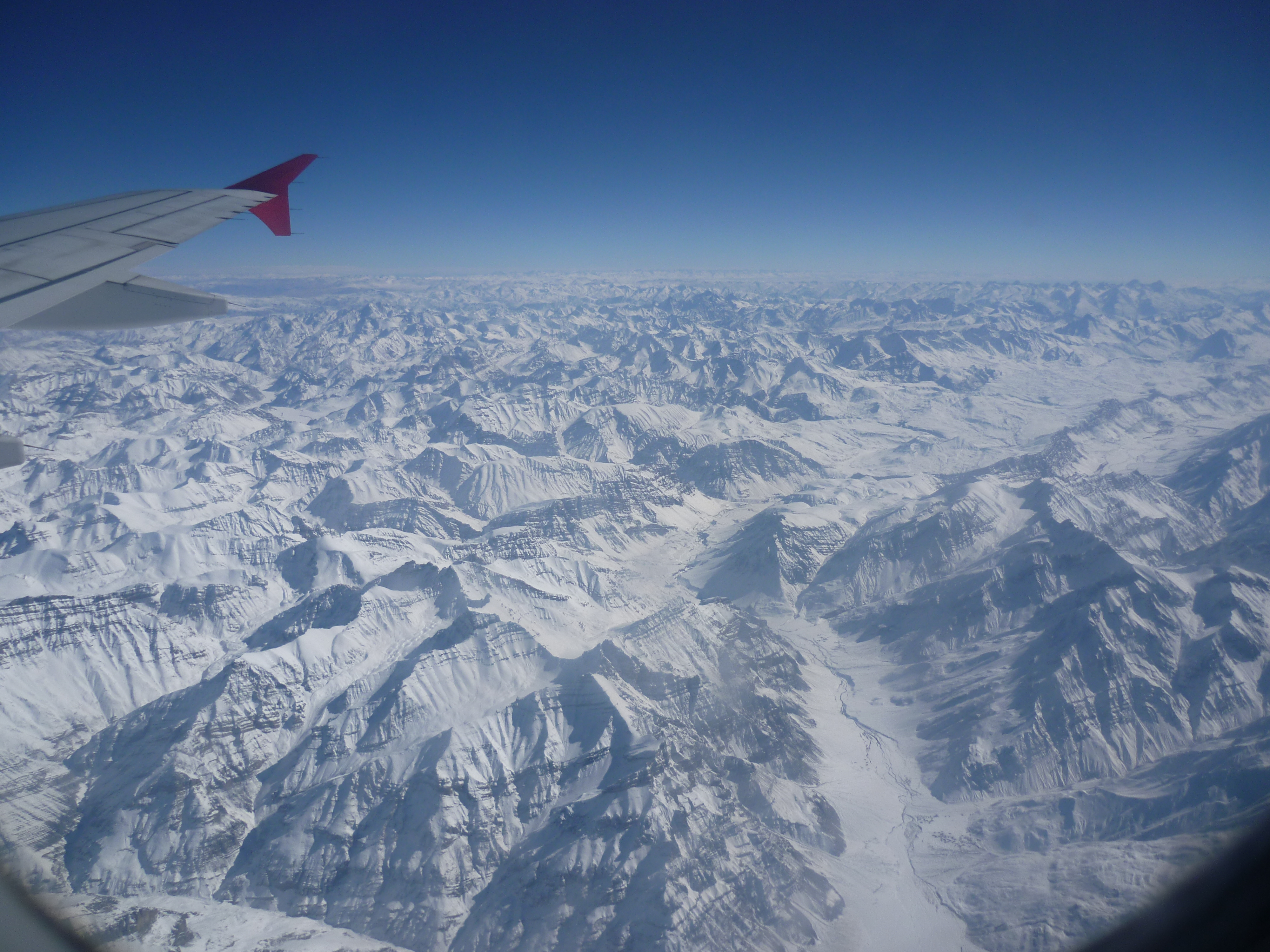
Day 1: It was noon by the time our early morning flight took off from Delhi airport, thanks to bad weather conditions. Just 20minutes after take off, a small but prominent layer of cloud seemed to appear at the horizon.. But within no time, we realised that we were approaching the Himalayas. In just few minutes, the GPS indicated Shimla on the map in the TV infront of our seats. A never-ending stretch of deep gorges, ravines, formed the beautiful landscape below. Few minutes further up.. Yes..!!! we couldn’t contain our excitement of flying over the snow covered mighty Himalayan peaks, we were jumping for a spot at the windows taking turns.. It was the first time we were seeing snow! Click click click…. The cameras went on and on… It was as if we were in an enclosure which was floating up in heaven.. It was absolute FEAST to the senses.. all the way… till touch down🙂
You are flying over the Himalayas…
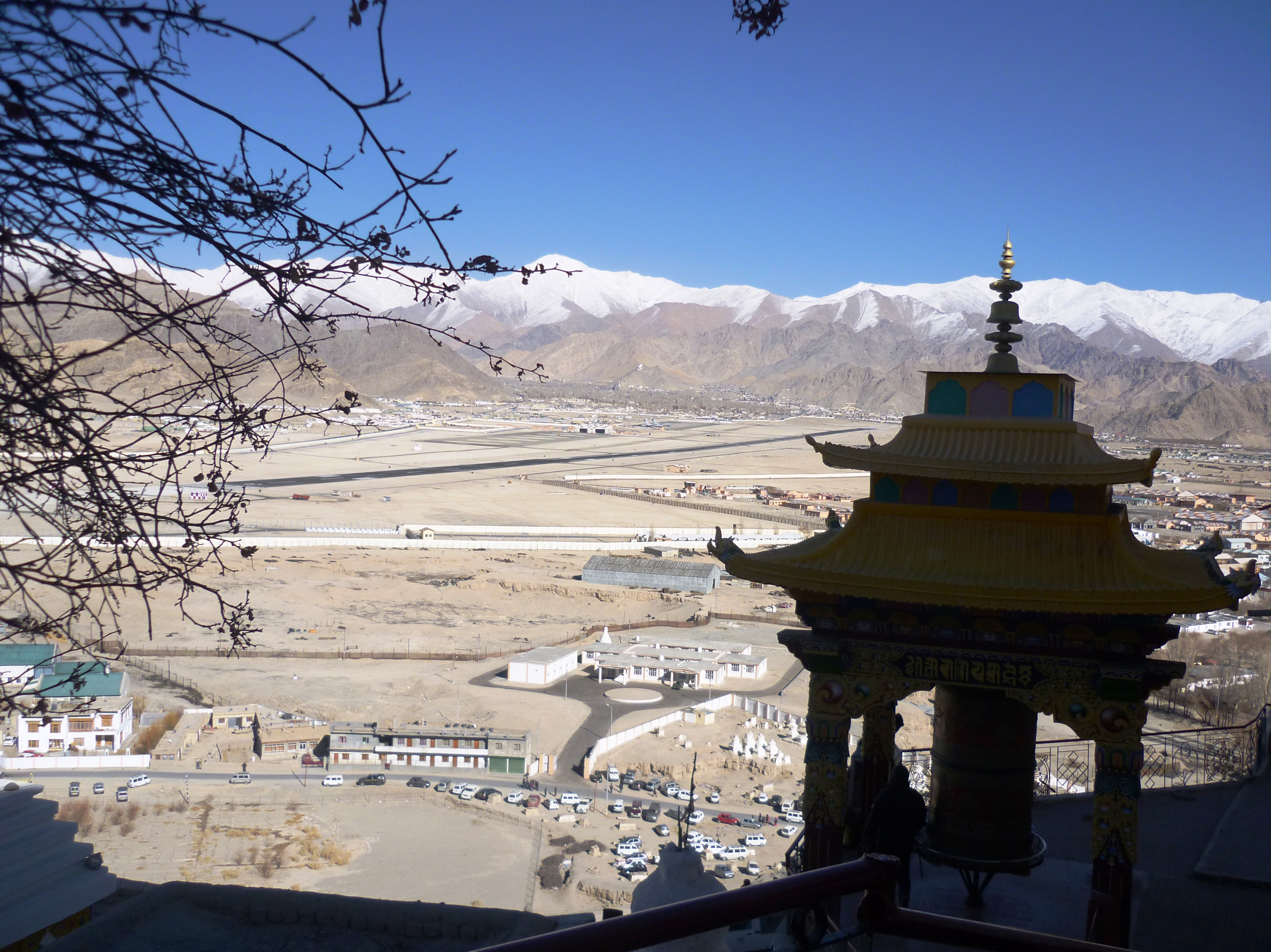
Inspite of the glaring bright sun, it was 6 below zero degrees when our flight landed at Leh- one of the highest airstrips in the world. We took a cab to the hotel that we were informed by the trek organiser.
The day went by just making an alternative plan for the trek that could not happen. Also, it was necessary to get acclimatized to a scary combo of High altitude + low temperature(It went upto -25deg on some days of our trip). So we just had to stay bummed to our rooms(without heaters..!!) and warmup ourselves 😛 We shopped for a lot of thermals in Leh market (we got cheap & good quality stuff..)
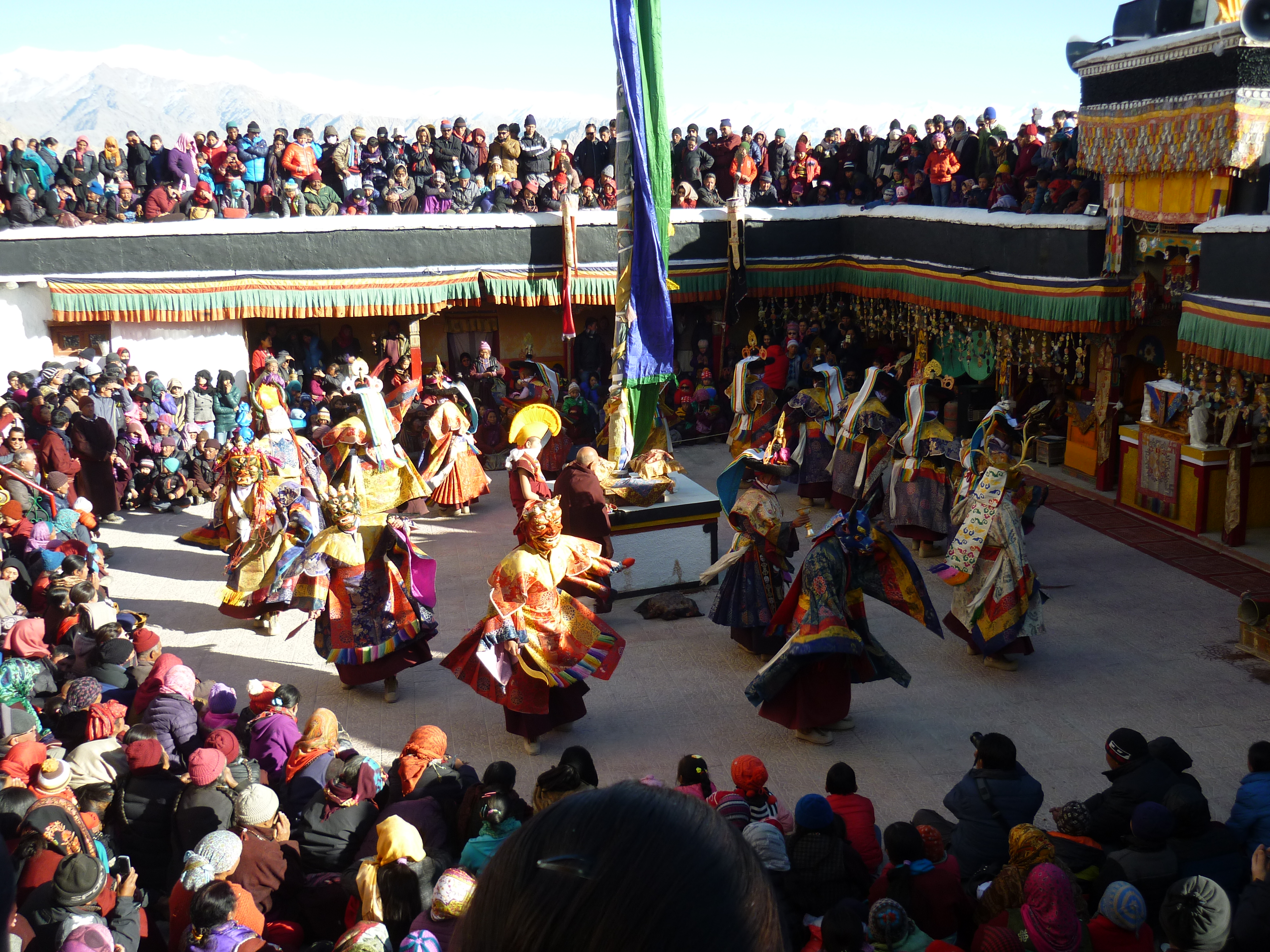
Day 2: It was the last day of the Gustor festival – the annual fair at the Spituk monastery– Enroute we visited the ‘Hall of fame‘- the war museum. We happened to be there at the right time when an Indian airforce carrier was about to land. With the Sham valley & other mountain ranges all around the airstrip, it called for the exact photo that had inspired me to visit Ladakh more than a year ago.. We later headed to the monastery where the day long festivities and mask dance was going on.. We walked up the stairs to the holy abode of Kali(which is open for public viewing only during Gustor festival) before we comforted ourselves by finding a seat amid the chaotic crowd that had assembled. After the event, we did a bit of souvenir shopping at the mela that was put up and a lot of binging on Ladakhi food. We took a cab to Shanti Stupa which is best for sunset viewing. After the sun was down, we took the stairs down which we were told was a shortcut to reach Leh town by foot.
Mask dance at the Gustor festival – the annual fair at the Spituk monastery
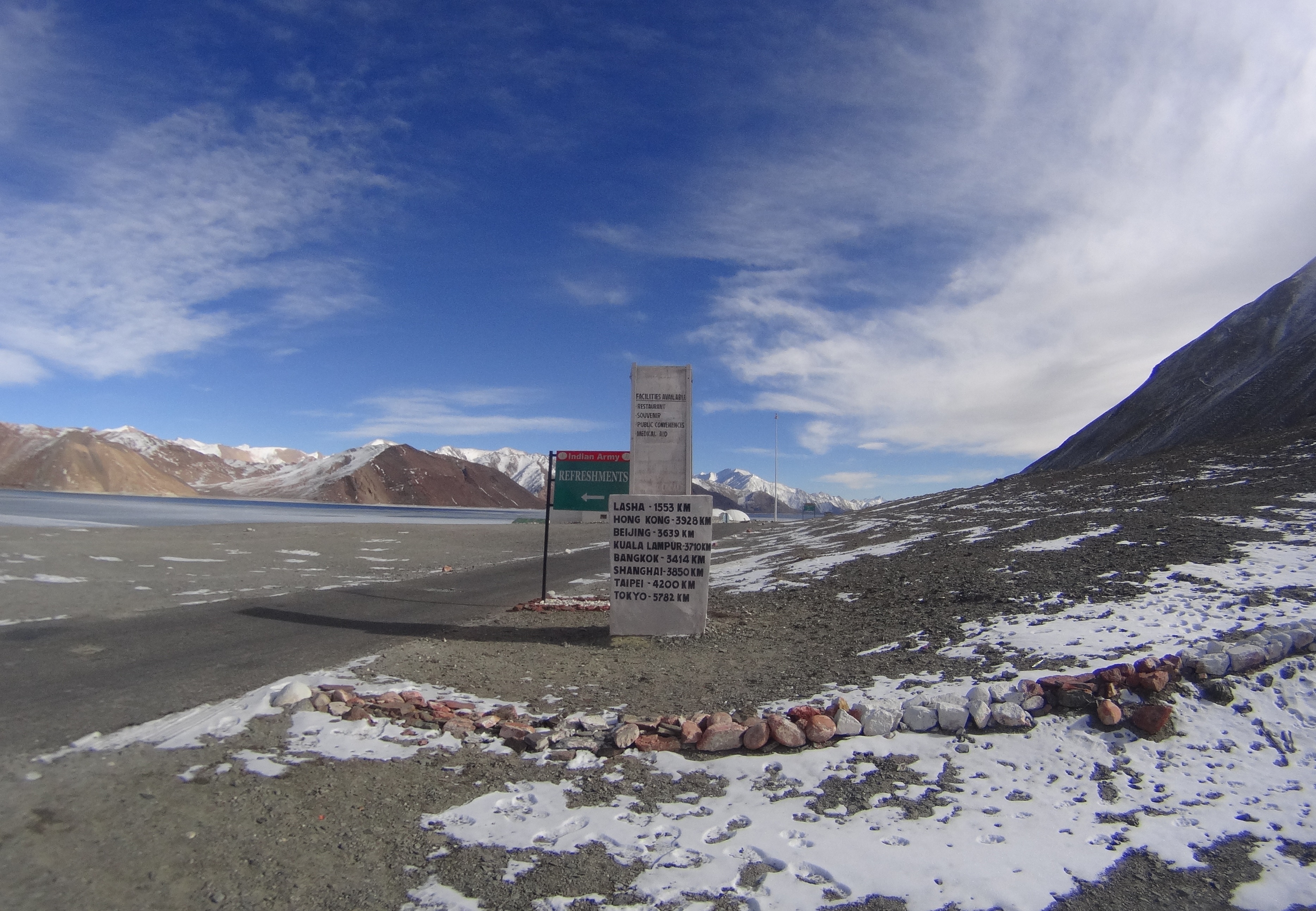
Day 3: Drive through Changla pass(the 3rd highest pass in the world) at a nerve freezing temperature: Get a quick grab of food at Karu town. Here one needs to get the Inner Line Permit to proceed towards Pangong Tso- the controversial border between India & China. The lake was partially frozen- where we could drive over most part of it and experience the chadar partially 😛 If one has an extra day, they could head to Tso Moriri, a salt water lake and camp there overnight before returning to Leh. But, we took back the same route so we could cover the Shey Palace, Thikse monastery & got a glimpse of the Rancho school of the ‘3 Idiots’ fame. Hemis monastery- the wealthiest monastery in India remained unreachable by road since it was winter.
A milestone at the Pangong tso
Day 4: It was a lonng day.. A wonderful drive on a roadless route which seemed to have been carved all out of ice and sprinkled with snow.. A small slip of tyre could get deadly as beautiful as the valley seemed to appear. We couldn’t ask for more when it began to snow just when we alighted at the end of the highest motorable road in the world- the Khardungla pass.Continue on the road that leads to the cold desert of Ladakh- The Nubra valley. With minimal vegetation, and sand dunes all around, you should not be missing out the ride on the Bactrian camels which are endemic to this region and is a critically endangered species. Visit the Diskit monastary- where a 32 feet statue of Maitreya Buddha looks upon Pakistan. Towards the end of the valley is the Siachen glacier- the highest battleground in the world and the glacier forms the source to the biggest irrigation system in the world-The Indus. Catch a good night’s sleep at a traditional homestay there and experience authentic Ladakhi hospitality.
View from a monastery
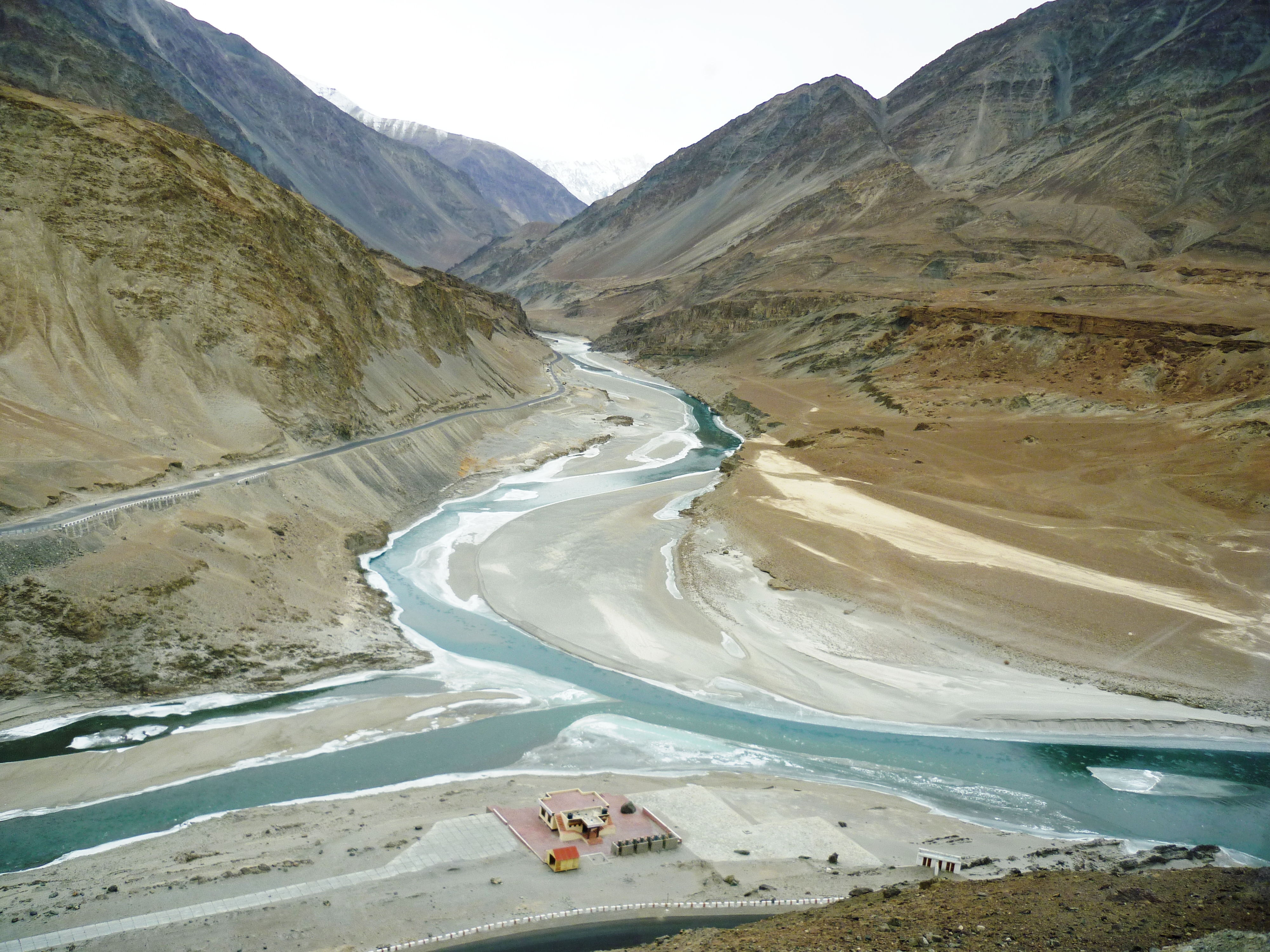
Day 5: Start early cuz the day will be short with too many places to cover on a single stretch from Leh. We took the Kargil road- a drive through Sham valley. First stop was at Nimmoo where we filled our fasting tummies. The next quick stopover was at Pattar Sahib Gurudwara. The straight stretch of road looked as if it was peircing right through the horizon. We were driving through the magnetic hill. The road which is believed to have defied gravity where a car with ignition off and neutral gear moves uphill- against gravity..!! We were not quite convinced with our experience though, which made us agree to the scientific explanation of it being an optical illusion. We arrived at Chilling- The confluence of the Indus and Zanskar. The partially frozen stretch was intimidating to walk over.. But we were warned by a cop not to go near the banks.. all thanks to section 144 😛
The confluence of the Indus and the Zanskar
We continued our journey through rustic Ladakhi villages, monasteries dotting the distant hillocks, frozen waterfalls, bare poplar trees, narrow truss bridges, army barracks, hot water springs, ice hockey fields, etc. We came across wild deers, yaks, pashmina sheep, wild horses and other fauna endemic to this high altitude region.. Likir monastery was beautiful with the Buddha statue smiling in between the snow clad mountains all around. Our last destination was Lamayuru monastery– The start point for many treks in this region.
Unfortunately, we did not have the luxury of a few more hours and safe conditions at the border to go further upto the Kargil border. We wanted to drive back through Drass valley- The coldest inhabited place in India and the second coldest in the world. Again, If I had an additional day in hand, I would have loved to get an inner line permit to spend a day at DhaHanu valley: home to the endangered community of the Dard people. I would love to go back ASAP atleast to document their customs, traditions, photograph their intricate jewellery and costumes before their numbers further deplete. Had I been blessed with a couple more days, I would want to do the Markha valley trek andand experience the tribal life in its raw & purest form.. And spot a snow leopard in its natural habitat at the Hemis national park- the largest national park in India and the highest national park in the world.
During winters, most of the town is shut for the season. The few places that are up, open after 11.00.a.m and close by 5~6.p.m. We missed out on some fine shopping of souvenirs, local handicrafts and dry fruits.. Probably, some form of connectivity of phone or internet could have helped us to cover more places and organise our trip in possibly a better way.. But, NO REGRETS..!! We’ve still done what most people don’t dare to- Experience the bitter winter of Ladakh. That’s all the time we had for.. We had to pack our bags with a super heavy heart to carry back home..
Day 6: It was a rare phenomenon that we had woken up with that day, early at 6.a.m. It was snowing in Leh. There usually is no snowfall at Leh town… But that day I guess the town had started to miss us… the sky was crying heavily.. We reached the airport by 07.30.a.m. The security measures are very stringent for those leaving Leh which easily needs about 2hrs. 2 rounds of passengers’ frisking and 2 rounds of baggage screening. And then, you have to individually identify your baggage until which it will not be loaded to the flight..!! Quite a strenuous task for the security personnel… While it is considered as a fun trip for the touristy people like us.. It’s a salute to the bravehearts : The Indian army.. Who bare all odds like extreme climatic conditions and unpredictable threats to their lives, strive day and night to ensure that we are safe.. The flight took off over the mountainthat said ‘Touch the sky with glory’.. in the true sense…